Good Sunday, everyone. Our second day of April is much better than our opening day as the high winds have finally calmed down. This leads to some nice weather ahead of a surge of very warm temps and another round or two of strong to severe storms in the coming days.
Temps this morning are in the 20s for some, but we do get a nice recovery by the afternoon with upper 50s to middle 60s.
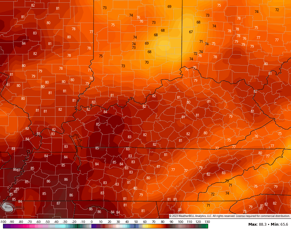
Monday features temps hitting 70-75 for many with a mix of sun and clouds and the chance for a stray shower or storm.
This is ahead of a push of very warm temps for Tuesday with highs likely reaching 80-85 in many areas…
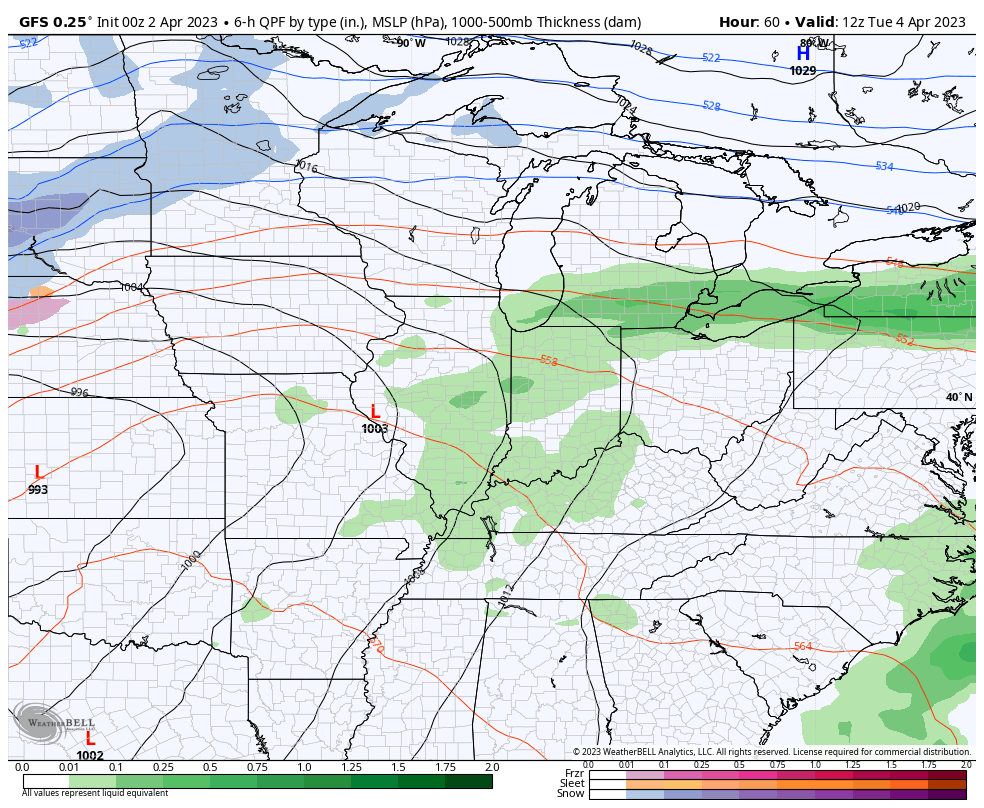
The threat for strong to severe storms will be with us later in the day, especially across the western half of the state. This is where the Storm Prediction Center is already highlighting this area for the severe risk on Tuesday…

That threat likely slides east Tuesday night and Wednesday as our system slides closer, sending a cold front through here…
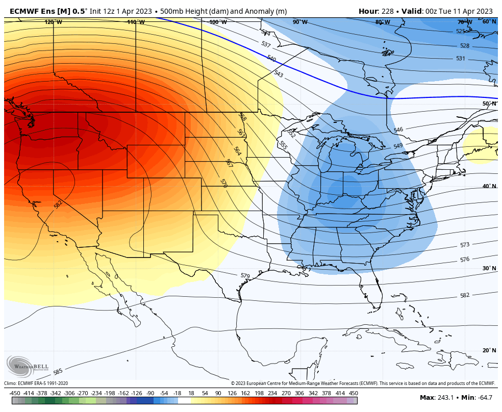
Chilly winds come in behind that on Thursday but temps bounce back to normal to start the Easter Weekend. There’s a system coming at us later Easter or early next week, with the timing on that still a bit of a mystery.
One thing that’s not a mystery is the deep trough pushing that in here for early the following week. This trough will likely lead to a few mornings in the 20s again before it lifts out later in the week. The models suggest we get a ridge to replace it by then…
I’ll take a look into May and the summer ahead in with updates in the coming week.
I may be able to throw you another update later today, so check back. Have a great Sunday and take care.

Thanks Chris. Wishing the energy coming off the Pacific would cease, and all would have tranquil Spring weather.
Given the unimpressive long-range forecasting we’ve seen in the last year or so, let’s come up with our own Summer 2023 prediction: It’ll be seasonably warm with fluctuations above and below the average. We’ll have periods of rain and drought. Some areas will have significantly more or less moisture. It’ll be a problem. Storms will crash through, disrupting power supplies (another problem). About midway through, we’ll be looking forward to cooler Fall weather.
It all depends on what phase ENSO will be in. Hopefully we will have a positive Pacific and a negative Atlantic. This morning it looks like we may be coming out of this pattern shortly after Easter. As for the Summer, I expect an above average Hurricane season in the Atlantic which may cause our Summer to be above normal in temperature and maybe below normal in precipitation. I will be watching and waiting for the PDO to go positive. If it stays negative, we will have very little change in the overall weather pattern.
Twelve tornadoes in Northern IL (9) and NW Indiana (3) have been confirmed by the NWS from Friday, the strongest of which were three EF-2s.
Unfortunately, the EF-1 tornado in Belvidere (near Rockford in Northern IL) killed one person and injured several dozen. This came at a theater where there was a concert going on when the tornado hit and the roof collapsed.
The entire Chicago Metro Area is under an Enhanced Risk of severe weather for Tuesday. We’ll see if this gets upgraded to a Moderate Risk like it did on Friday.
I didn’t know this, but my county was under a Tornado warning early Saturday morning. One was sited on Radar. Chris mentioned this on his twitter feed. It’s just a matter of time before one hits my property and sends me to Oz. I think the jury is still out for the storm for Tuesday and or Wednesday.