Good Sunday to one and all. It’s a cool and wet day for areas of central and eastern Kentucky as our storm system rolls in from the southeast. This holiday weekend disruptive system has been on the KWC radar for well over a week now and it’s finally here.
The greatest rain threat continues to be across the central and east with heavier amounts in the east. There’s the chance for a stripe of 1″-2″ rains to show up in the east with lighter amounts into central Kentucky. A shower or two may make it all the way into the west.
Here are your radars to track today’s rain…

Areas with the clouds and rain may not get out of the 50s today while the west makes a run into the 70s with enough sun. Those with clouds and just a stray shower or two will be in the 60s.
Today’s weather is all about location, location and location.
Memorial Day features lots of low-level moisture and the chance for a shower or storm going up, especially in the east. Temps are problematic as clouds may do a number on the numbers into central and eastern parts of the state. Highs will struggle to get to 70 in the east and be in the mid and upper 70s with an 80 west.
The pattern after this turns much warmer and may flirt with toasty levels for a few days as we head into early June.
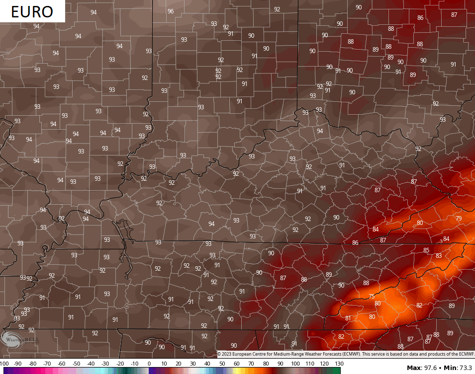
You guys already know my disdain for temps coming from the EURO Model. They are WAY to warm year round, but they seem to really take it to another level in the summer months. Each of the past several summers, forecasts from the EURO Model were for temps to reach and exceed ALL-TIME record highs in Kentucky. When the verification days came around, we weren’t even within 15-20 degrees.
The current run of the EURO is forecasting low and middle 90s around here by the end of the week with some upper 90s in the Ohio Valley…
The GFS at the same time is much cooler and likely too cool…
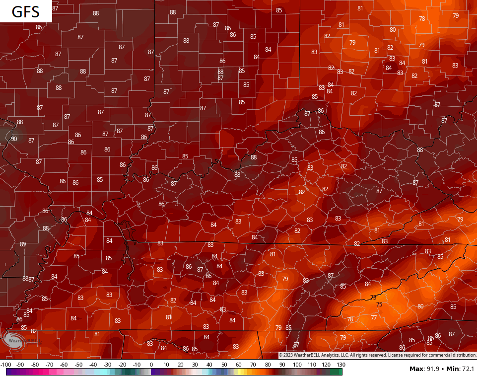
The reason is the GFS sees some scattered showers and storms around.
The truth is likely between the EURO and GFS forecasts, as usual.
Even though June starts toasty, the pattern flips soon thereafter. The ENSEMBLES continue to put the heat ridge along the west coast and bring another trough into the eastern half of the country…
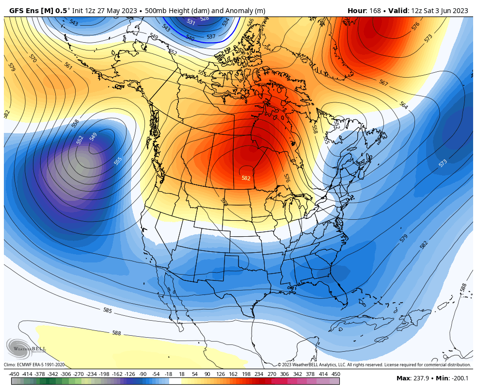
The GFS temp departures from normal during that time…

Have a wonderful Sunday and take care.

Here we go….entering June… Let the heat begin (after these cool rainy temps)….. I will mention this…even with AC.. I sleep SOOO much better in winter than I do summer
Thanks Chris. Maybe some sprinkles here in Maple very soon, but I don’t expect more than that, and we really need another soaker rain like we had a week ago. With time model forecasting will likely change to more accuracy, but not in our lifetime. Currently there’s a 91 degree high in my local forecast for next Saturday. Before that it may be in the mid to upper 80’s. Along with that only a 20 to 30% chance of afternoon showers developing daily. Sounds like our typical Summer will arrive on time.
A few insignificant rain showers today is the only rain I see in the forecast for the next 10 days.
It looks like my water sprinkler will be in operation soon.
Btw, HRRR long range model has been nearly accurate regarding today’s forecast.
Chris you were right we have had a good soaking rain all day still am in the east! We are in the 50s for highs. Glad I got out yesterday and did things I needed to do. This feels like the coolest Memorial Day we have had in my area I would be interested to know if it is. I turned my heat on can’t remember doing that on Memorial weekend.
Crystal, if this weather pattern occurred in February or March your area would have at least a couple of feet of heavy wet Snow. Maybe that will happen next Winter. Next Fall and Winter will be quite interesting.
I thought about that Schroeder