Good Thursday, everyone. Rounds of strong to severe storms are targeting the region today and this is a trend locking in all the way through the upcoming weekend. Outside of storms, we have a lot of steam that’s out there.
Let’s focus on today’s rounds of storms then roll forward.
These storms will be working in from northwest to southeast with the greatest impact likely to be across parts of western and central Kentucky. These storms may contain damaging winds and large hail with the potential for a brief tornado or two.
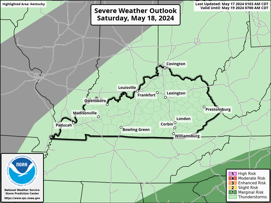
Here’s today’s Severe Weather Outlook from the Storm Prediction Center…

Here’s a breakdown of the individual threats we’re facing…
Damaging winds…

Large hail is also likely with some of these storms…

The low-end tornado threat is there, especially in areas along and west of Interstate 65…

The overall threat then fans out to include areas of the rest of the state for Friday…
Let’s focus on this Friday threat and use the Future Radar from the Hi Res NAM as a tool. This animation starts after late tonight and goes through 8am Saturday. You can clearly see how these storms impact more of the region and come at us in waves diving in from the northwest…
Once again, damaging winds and large hail are the main severe weather threats with a much lower tornado risk.
The NAM has a similar look Friday into Friday night but goes deeper into the weekend than the Hi Res does. Watch how this model sees additional rounds of storms rolling in through Sunday morning.
This animation starts at 8am Friday and goes through 8am Sunday…
Additional storms would then take us through early next week, but they should become more scattered.
This setup has me concerned on two fronts. The first is the damaging wind threat with these storms. The second is from the potential for some areas to get in on enough rain to cause significant flooding issues. This is flash flood season in Kentucky and storms on the leading edge of heat can be prolific rainfall producers. Stay alert!
I will update as needed and be on WKYT-TV as needed today. I leave you with your storm tracking tools…

Current watches

Possible Watch Areas

Have a great day and take care.

Thanks Chris. Uncertainly in the severity of the storms through the weekend says the NWS. More confidence in the precipitation amounts. With that said, I don’t feel that secure. The forecast now is for ” unsettled weather ” over the next few days.
A Severe Thunderstorm Watch is in effect for much of IL this afternoon, including the Chicago Metro Area, as an organized MCS has entered W and parts of NW IL, with numerous Severe Thunderstorm Warnings currently in effect in that area for 70 MPH winds and large hail.
The worst of the severe weather is going to be in Central IL, where there is a Moderate Risk of severe weather (level 4 of 5).
The radar image echos looks very dangerous at this time over central Illinois. A Bow Echo heading into central Indiana. Probably will move towards central Kentucky this late afternoon or evening. Hope it weakens considerably. Mike, I heard on the radio and TV that Chicago yesterday had the most unhealthy air in the entire World. Is this true or is it more BS from the NEWS ???
Actually, that was very true! On Tuesday, Chicago had the worst air quality in the world among 95 cities, according to a site that monitors air quality. The haze and smoke from the Canadian wildfires were very prevalent throughout the area. The last two days, the air quality has improved, though it’s still in the unhealthy category. The heavy rain that should be here shortly should really clean things out, fortunately.
That’s really an impressive bow echo line of storms in South-Central Indiana now, and it looks like it’s headed straight for Louisville.
To the NW of the MCS cluster, there’s a separate line of strong storms headed for the SW Suburbs of Chicago, where dewpoints currently are around 73 degrees, providing plenty of fuel for the storms.
That is a very strong Bow Echo. I haven’t seen one that strong since June 8th, 1982. Hope your air clears completely soon. Our mornings are still ugly with that Smoke. Hopefully, we will have a good rain this evening, but the NWS said that the line of storms may lose it’s upper air support as it moves southeast. That would be a good thing. Take Care, Mike
Beneficial rains fell here in the SW Suburbs of Chicago this afternoon which helped the air quality somewhat and also helped alleviate the ongoing drought, but without the strong winds and severe weather that slammed through Central IL earlier in the afternoon with the bow-echo complex. Wind gusts between 75 and 90 MPH caused damage in many areas there.
I see you guys are getting heavy storms and welcome rains in Central Kentucky, which will hopefully stay below severe limits.
Here in Maple we have calm winds and very little rain has fallen. Glad the storm fell apart. Means no power failure. I guess we will have to wait on the next wave, and I hope it doesn’t look like the one that went through central Indiana this afternoon.