Good Friday and welcome to the final day of June. We are sending the month out on a steamy and stormy note with more rounds of big boomers. These rounds of strong to severe storms will be around through the upcoming weekend.
Before we get into the severe threat, let’s talk about the western Kentucky heat. Temps can make a run at 100 in some spots and, with high humidity, heat index numbers from 110-115 will be possible in a few spots.
Temps across the rest of the state won’t even be close to that.
Our day starts with storms impacting parts of central and eastern Kentucky and some of those could be strong and put down very heavy rains. Once those move away, we are likely to see some steamy sun fueling additional thunderstorms to develop and roll across the region. Those may very well be strong to severe.
Here’s today’s Severe Weather Outlook from the Storm Prediction Center…

Here’s the breakdown of the individual threats we’re facing today…
Damaging Wind

Large Hail

Tornado Threat

This threat will then continue into the weekend. Once again, damaging winds and large hail will be the biggest players as the storms try to fire in more of a west to east fashion.
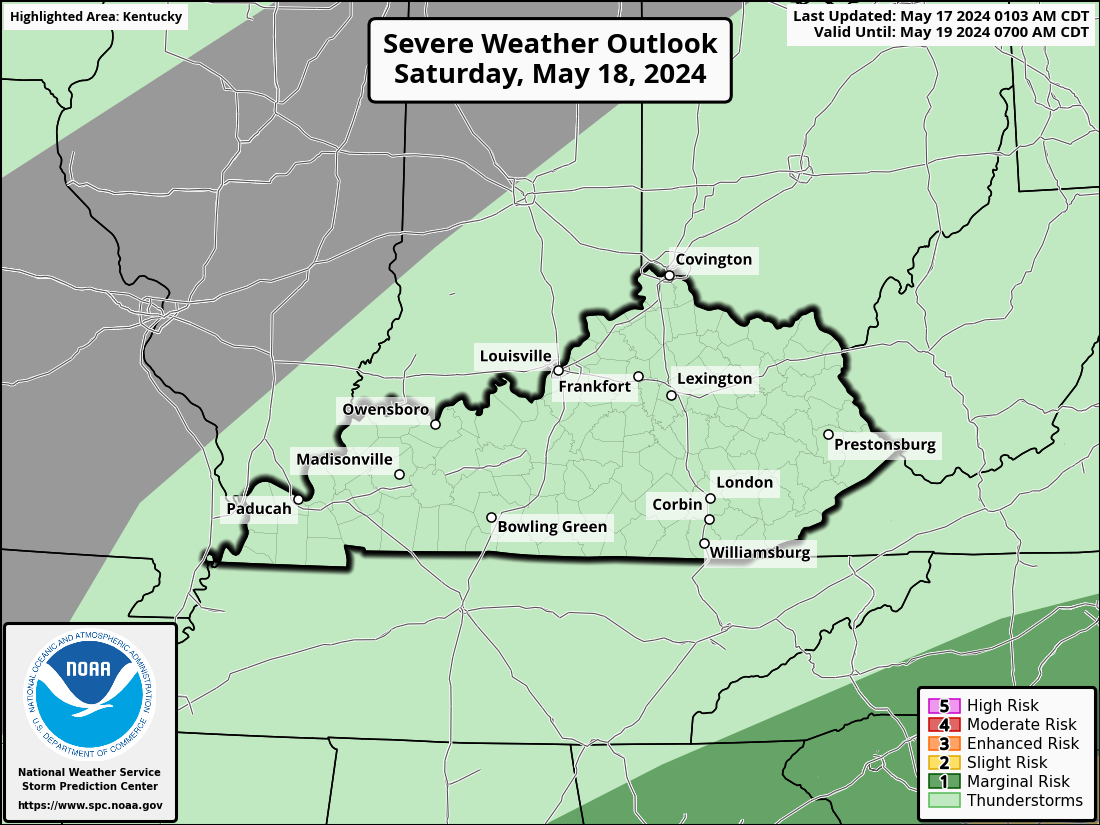
Here’s the Severe Weather Outlook for Saturday…
And for Sunday…

Scattered showers and storms continue into Monday with a lower chance for the 4th of July on Tuesday.
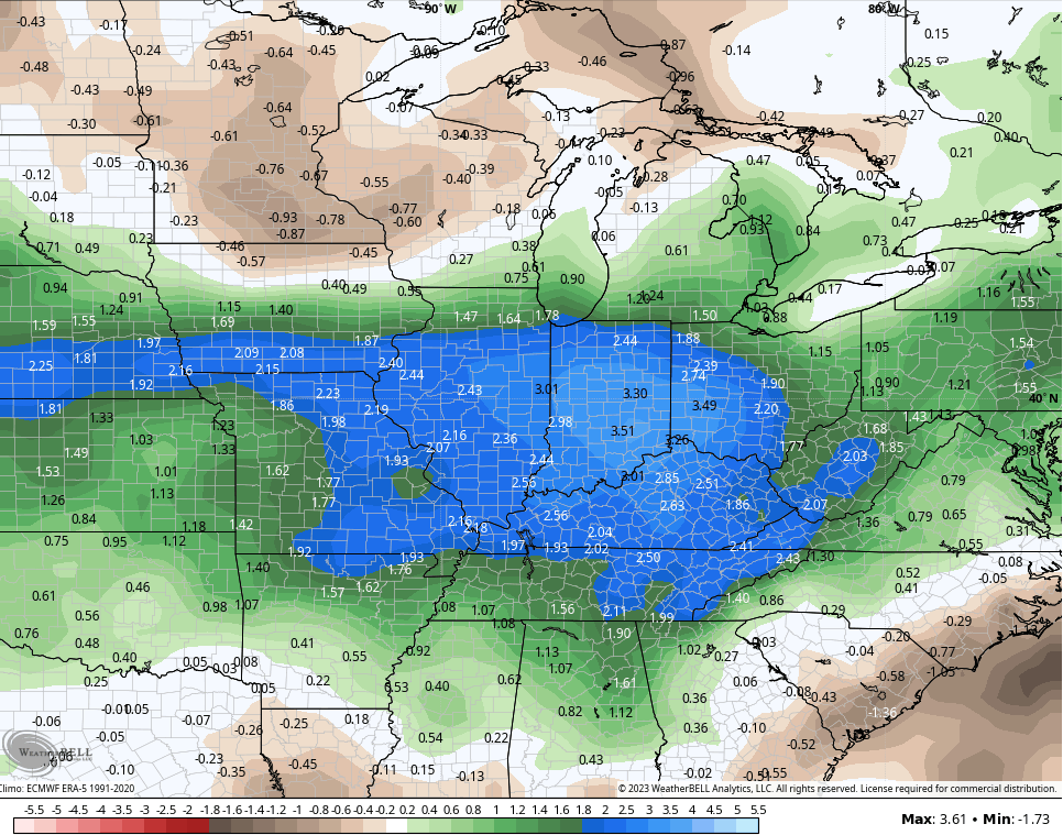
More storms are likely later next week as this above normal rainfall pattern continues. Look at how far above normal the GFS Ensembles have us over the next 2 weeks…
I will update as needed and be on WKYT-TV as needed today. I leave you with your storm tracking tools…

Current watches

Possible Watch Areas

Have a great evening and take care.

Heat and some dryness will soon win.
And?
It won’t be as rainy or cool. Believe it or not, most areas are in good condition once again.
even better now that it’s rained over 2 more inches ….
Actually, the storms we just had are my favorite…I hate severe weather but love storms.
At least the air quality is better.
Good soaking rains Mark in the Lexington area. We are beginning to dry out once again here in Maple, but the crops are okay with the higher humidity.
That’s right Jeff. Scattered areas escaped the severe weather. Here in Maple we received only the typical Summertime thundershowers. The rainfall only amounted to 0.22 on the mesonet. We will see what happens the next few days. I would like to see an end to the severe weather threat before the Fourth of July. One of my favorite holidays.
Actually it was very comfortable yesterday at my house.
A nice cool breeze after the two rounds of rain.
And the rain & wind did temporarily washed the atmosphere.
We miss out the rain yesterday here in my neck of woods here in western,ky. Bone dry hopefully we will get some moisture ,but no storms please mother nature.
Hoping that Mother Nature cooperates and gives your area of Western Kentucky a great soaking rain for all the Farm fields in your area Winterlover. After this coming week, we can turn our thoughts to the Fall and Winter ahead. Could be interesting.
Schroedoer hope your right and yes looking forward what will this fall winter will turn out.
Hoping that Mother Nature cooperates and gives your area of Western Kentucky a great soaking rain for all the Farm fields in your area Winterlover. After this coming week, we can turn our thoughts to the Fall and Winter ahead. Could be interesting.
We finally got some decent rain at my locale south of Bowling Green, with 1.25″ falling over the course of 2 storms, including a Tornado Warning around Noon CDT. Turns out it was radar-warned mesocyclone, with broad circulation. No touchdown, but we were buffeted by strong winds, over 40 mph.
That’s a good rain Joe, and your area really needed it. We need more rains here in Maple, but overall the crops are in great shape. Just in time for pollination.
Chris, the two radars on your blog are not corresponding. I don’t know which one is right ? Maybe I’m looking at ground clutter.
It’s probably a glitch, Schroeder. I’m seeing that on a couple of my site-specific radar apps. I believe it’s old data emanating from the Ft. Campbell site, because when I select that particular radar, it gives me a “Data too old/Network or radar problem” message.
Thanks Joe for explanation on the radar.
Here’s the satellite link to the Great Lakes and the Ohio Valley. One can tell which way the storm waves are going, but it doesn’t compare what you can learn on the radar.
https://weatherstreet.com/great-lakes-us-weather-satellite.htm
There is plenty of fuel for storm intensification in the Bowling Green area. Right now, the temperature at my PWS is 90°F, the humidity is 74%, and the dewpoint is 80°F. Could see CAPE values in the 3,000 to 4,000j/kg range, which will create a strong CAP. But if storms grow and break through, look out!
Always that 50 /50 chance of that happening. We been lucky so far in my neck of the woods. It’s just a matter of time before one of those supercells clobbers us.
Looks like the heat is here lol. It tried to rain a few drops yesterday but never amounted to anything. I wonder if heat or hot weather causes the animals to come out to seek water or what not?? I have seen several deer in the neighborhood we hadn’t seen any In Forever and we have a neighborhood large black bear and he comes right up to the houses in the middle of the day but the one he wants in the most has a large swimming pool it’s like he’s fascinated with it. I guess they are hot too.
picked up another inch of rain in Corbin
At 4:15 pm CDT my PWS near Bowling Green recorded a temperature of 97°F, humidity 62%, dewpoint is 83.2°F, and the heat index is an absolutely crazy 124.5° F. Not seeing many on the radar, atmosphere appears to be capped right now. If that cap should break, look out!