Good Friday to one and all. We are bookending our weekend with some very steamy temps as temps hit some of the toastier numbers of the entire summer. Sandwiched in between is a stormy Saturday with rounds of boomers blowing through here.
Let’s begin out there today and roll forward. Highs today are generally in the upper 80s and low 90s with humidity making it feel even warmer. There’s the chance for a storm or two going up but much of the day looks dry.
There is a low-end risk for a few strong or severe storms getting into western Kentucky this evening. The SPC has the low-end risk in this area…

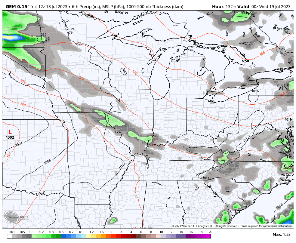
Here are your radars to follow any boomers that blow up today…

Rounds of showers and storms then increase tonight into Saturday, but this doesn’t look like washout type stuff…
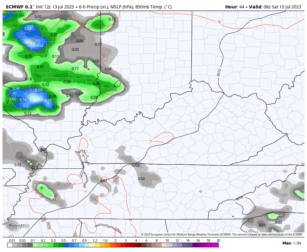
A few strong to severe storms will also go up and the SPC has just about the entire region in the low-end severe weather risk for Saturday…

Sunday is toasty with just a small storm risk.
The storm threat then increases Monday and Tuesday as a front crosses the region. A few more strong storms with heavy rains are possible during this time.
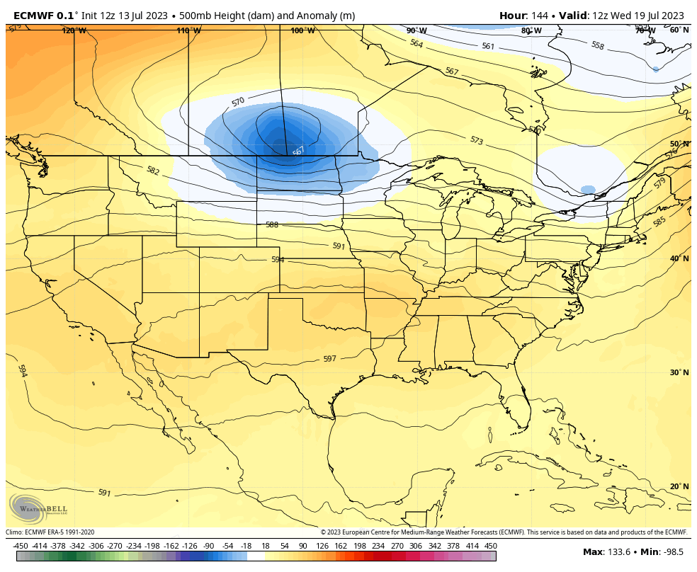
We will likely get a quick-hitting surge of heat by late Wednesday or Thursday as the lower plains heat briefly expands eastward before another big trough swings back in by next weekend. The models are in good agreement on this…
EURO
GFS
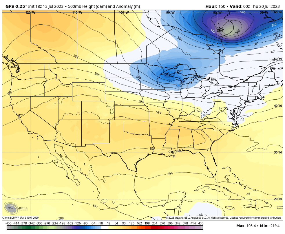
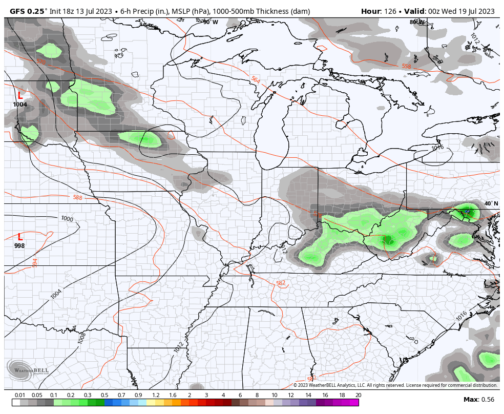
The potential for some big time thunderstorm clusters is there before that trough digs in. The models are in good agreement on this as well…
GFS
CANADIAN
EURO
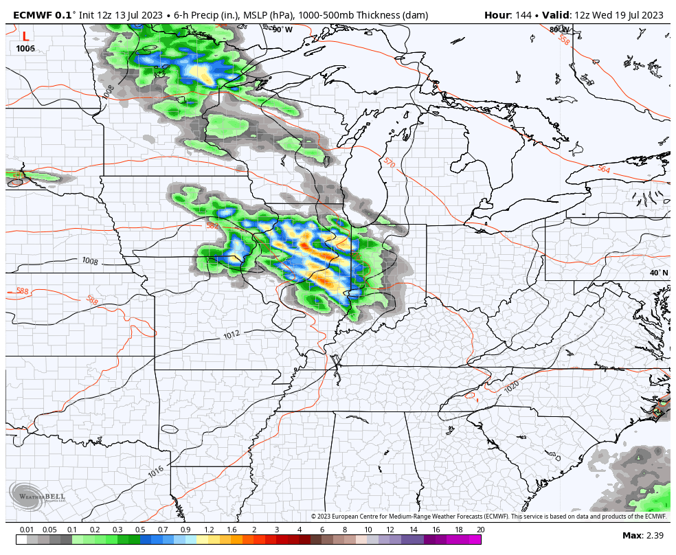
That’s the setup for some big storm clusters, folks.
The trough coming in behind that has some staying power. This is the 10 day average…
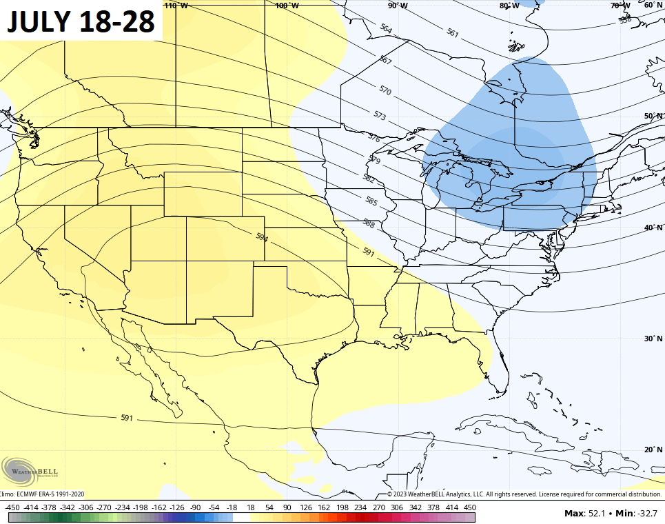
That puts the heat back to the west and cooler than normal numbers in the east. Not bad for the second half of July!
Enjoy your day and take care.

#TeamSummer #TeamHeat
Unless you’re living in a swimming pool… why would you want 90s and humidity?
I simply want each season as it normally is. Every season has its place and I enjoy the changes from one to another.
Apparently you don’t have to work out in the heat like some people do and i’m one of them. Heat puts lot of stress to your body even you drink lot of fluids. Take the heat with you!!
Nice gaslight there.
Not a bad forecast for July.
Heat never did bother me that much, as I worked out in the nursery every single day. I did welcome the cooler and frosty days of Autumn. I hope we have Autumn like weather this year like last year. Beautiful weather.
NOAA’s still predicting ENSO for this Fall and Winter. It won’t be El Nino until the Pacific Decadal Oscillation turns positive. No mention of this on the latest ENSO Blog. Back in August 1976 the Pacific Decadal Oscillation turned positive giving our area a very cold Snowy Winter 76 -77, and lasted through early 1979. In 2015 -16 was the last time the Pacific Decadal Oscillation was positive and we had a bout of cold and heavy Snow in February. In my opinion, I don’t see that happening this Winter, as the record warm Atlantic Surface Sea temperatures will help ” fizzle ” the weak El Nino we have now. Also the Southeast Ridge will dominate once again in a positive charged Atlantic. During this long Climate Cycle we have had very few cold Winters. No one knows when an end is in site to this long playing Earth Cycle. Maybe we will receive one of those rare cold Snowy Winters in the years ahead ???
Good to see you back on here Schroeder.
Yeah, I enjoy commenting on the weather with my friends on KWC. I still don’t understand why I have to join Twitter to view all the beautiful photos on Chris’s Twitter Feed ?
Here’s an interesting article explaining the PDO and ENSO phases. It explains a lot with the climate these days over North America.
https://www.nasa.gov/vision/earth/environment/PDO.html#backtoTop
Here’s the explanation of the Atlantic Multidecadal Oscillation. Very important in forecasting long range for Atlantic Hurricanes and seasonal forecast like the Winter outlooks. The AMO is currently positive.
https://climatedataguide.ucar.edu/climate-data/atlantic-multi-decadal-oscillation-amo
I’m not convinced that a positive PDO will be the determining factor in triggering an El Niño, primarily because the steady increase in global atmospheric temperatures has changed the rules. Here are the current SSTA chart and two SSTA charts from Nov. 1997 and Dec. 2015, which occurred in the midst of the two strongest El Niño events in he past 50 years. The effect of much warmer than normal SSTA levels in the Northern Pacific on mid and upper level winds, will have far more influence on our weather, than lower than normal Temps in the Western Pacific.
Current SSTA
https://www.ospo.noaa.gov/Products/ocean/sst/anomaly/index.html
Nov. 1997
https://www.ospo.noaa.gov/data/sst/anomaly/1997/anomnight.11.1.1997.gif
Dec. 2015
https://www.ospo.noaa.gov/data/sst/anomaly/2015/anomnight.12.3.2015.gif
Joe very interesting charts. As you can clearly see the difference in the El Nino forming now and the previous ones in the past. Those in the past years show fully formed El Nino’s with a positive PDO and a negative AMO. Maybe this will happen with the current El Nino later this Fall and Winter. NOAA tells me. Will have to see what happens in four to six months. Thanks for sharing.
Schroeder, we may know sooner than that. Substantial shear, a hallmark of past El Niño’s has become established in the eastern Caribbean. This shear has already prevented a couple of tropical storms from intensifying, and steering winds are positioned to take the remnants to the east of Bermuda. The atmosphere globally is more energetic than in recent years, and is also holding more moisture from increased evaporation, which is tending to accelerateweather processes, including. The bottom line is that those warm water patches in the northern Atlantic and Pacific will play an important role in the upcoming Winter, especially in terms of modifying the path of the Polar jet.
One other point is that those two strong El Niño’s of 1996/97 and 2015/16 both averaged warmer than normal at the start and finish, but both also produced at least one major snow event, sandwiched in the middle.
I remember one weak El Nino event in 1969 -70 in South Central Indiana that produce one Snowstorm after another. Snow was on the ground every week starting in December and ended with a beautiful Spring in April 1970. I hope your right Joe with your predictions on what this El Nino event may bring.