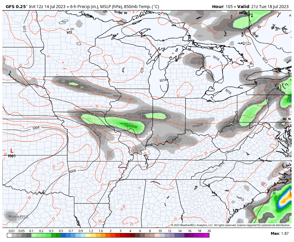
Good Saturday, folks. Our weekend is off and running with steamy temps and rounds of thunderstorms on the increase. These storms rumble through today and may put down heavy rains and flirt with severe limits for some.
Low pressure is rolling in from the Mississippi Valley and looks to bowl from west to east across Kentucky today. This spin fires up rounds of showers and storms that can put down torrential rains along and ahead of the track of the low. This may lead to local flash flooding in a few spots.
Some storms will be around this morning but those look scattered. The greatest risk for strong to locally severe storms comes this afternoon and evening. The Storm Prediction Center has the low-end risk for much of the state today…

Here’s your breakdown of the individual threats for our Saturday…
DAMAGING WIND

LARGE HAIL

TORNADO THREAT

This isn’t all day rainfall by any means, so you will have dry times to get out there and enjoy. Temps outside of storms generally range from the low to middle 80s with 70s in the rain. Western Kentucky will be a bit toastier.
Sunday brings us more in the way of toast with a lower threat for a storm or two going up.
Scattered storms will be with us Monday and Tuesday as temps come down a bit. I’m still focused on the potential for a few big time clusters of storms to impact our weather from Tuesday night through Thursday. The models are picking up on this…
I will drop by for updates as needed throughout the day. Don’t forget to follow me on all forms of social media:
Twitter: https://twitter.com/Kentuckyweather
Threads: https://www.threads.net/@kentuckyweather
Facebook: https://www.facebook.com/ChrisBaileyWKYT
Instagram: https://www.instagram.com/kentuckyweather/
YouTube: https://youtube.com/@Kentuckyweather
I leave you with your Saturday storm trackers…

Current watches

Possible Watch Areas

Have a great Saturday and take care.

We really need the Rain now, but the precipitation pattern has not changed. All the good soaking Rains are far to our North and moving Southeast towards Southwest Ohio and Eastern Kentucky. I’m hoping we receive at least one of those scattered afternoon and evening Rain / Showers. Yesterday was the most uncomfortable day so far this Summer season. A high temperature of 91 degrees with high dew points in the 70’s. Looks like that tame Summer with high temperatures in the 70’s and mid 80’s with dew points in the low 60’s is over. Ready for Fall weather if we receive such.
I love Fall too Schroeder. We have been lucky about having some good downpours here lately. I saw something that said smoke was coming bad to our region because of the fires anyone else heard that??
I’ve read the same. This morning NWS Forecast Discussion from the Louisville office mentioned that we would start seeing this aloft tomorrow.
When we get that Northwest flow the smoke will return. I heard that they are not controlling the Wildfires in Canada. Don’t really know if that is true.
I’m sorry Chris. I just found out that you can get all the photos and your weather on Threads. Please excuse me for being so internet illiterate.
What is threads???
It’s just Zuckerberg trying fo imitate Twitter. Nothing more.
LOL ……
Lol Jeff
Here’s hoping that folks like Schroeder get their needed rains. Here in Madison County we are in good shape.
Hope so as really need the Rain in my county.
I wish I new more about the internet. I grew up in a world that had encyclopedias and dictionaries.
I still cannot understand how you cannot see photos on Twitter via browser. I doubt Chris has flagged your IP address. Because you are able to gain access through other sources or means.
You cannot make comments on Twitter without an account.
I think Chris wants anyone interested to join Twitter. He has really expanded his Blog by all the social media sites. I really think he will do very well. I like the comment section for conversation and weather discussion.
On Friday evening, for the third consecutive day, a Tornado Warning was issued for parts of the Chicago Metro Area. A line of strong thunderstorms that moved through caused a confirmed tornado touchdown in the Western Suburbs. There was wind damage in other parts of the area from the storms also.
On Thursday evening, there was radar-indicated rotation in a storm that caused a Tornado Warning to be issued for a brief time in the far NW Suburbs.
This pales in comparison to the major tornado outbreak that occurred late Wednesday afternoon and early evening across the Chicago area. The Chicago NWS has confirmed that 13 tornadoes touched down. Three of those were rated EF-1, and the other ten EF-0. They caused a considerable amount of damage but fortunately no serious injuries or deaths. Around 7 PM that evening, there were tornadoes occurring at the same time near O’Hare Airport and Midway Airport!
Here is the link for the complete summary of that tornado outbreak, along with some pretty awesome photos of some of the tornadoes (click on photos). https://weather.gov/lot/2023_07_12_Tornadoes
Fun Fact: As of July 10th, Illinois leads the US in most tornadoes so far in 2023 with 100 (which will go up considerably after the latest tornado outbreak). Alabama is second with 91, and Texas third with 78. Kentucky is way down the list with only 27 tornadoes this year.
https://spc.noaa.gov/climo/online/monthly/2023_annual_summary.html
Mike my sister had a tornado in Greenwood Indiana recently. It didn’t damage her home but it did her neighbors in Bargersville the closest one has ever got to her too close, I wonder what the deal is they are more and more of them??
I’m sure you saw the amazing video footage of that tornado on YouTube.
Yes I did
Crystal, look at these photos of twin Tornadoes in the Indianapolis area that occurred in April 1965.
https://www.weather.gov/ind/palmsuntor
Oh my goodness
Mike you have gotten some great Rain events. I wish the severe weather and Tornadoes would cease with the storms. We have had some Tornado touchdown earlier in the late spring and early Summer, but mostly wind events. Now my county is receiving a nice little Rain / Shower.
Interesting data on the severe weather since January 1st. Thanks for sharing.
So far this month, O’Hare Airport has received 5.76 inches of rain, while the NWS Forecast Office in the SW Suburbs has received 6.98 inches. Hard to believe now that we went three weeks without any measurable precipitation in June.
Good to see your area getting a rain shower today. Every little bit helps!
We had about 0.22″ Mike. I can’t recall any Rains that totaled over 5 inches in this area of Kentucky. I been living here in Maple for 15 years. I think the ridge to our south / southeast keeps a cap on the atmosphere. The same ridge that keeps the Snows away. If we get a well formed El Nino this Winter, maybe the southeast ridge won’t be as strong. Don’t know.
It’s really coming down now I don’t think it will last long but still nice to get the rain.