Good Monday, everyone. Our work week is starting off with a few showers and storms rumbling across the region. This kicks off another stormy period with waves of boomers that can be strong and cause some high water concerns in the coming days.
Let’s begin with the severe weather risk then we will get into the flooding potential.
A complex or two of storms will be working in from west to east today and a few of the storms may be strong. The Storm Prediction Center continues to place the region in the low-end severe weather risk today…

This low-end risk then looks like this…

And then here’s the Wednesday low-end risk…

I’m much more concerned about the potential for the rounds of storms later tonight through Wednesday. That’s when multiple rounds of storms move through with the potential for some of these storms to move over the same areas one right after another. With juicy air in place, that’s fuel for the heavy rain fire.
This will NOT be wall to wall rains and you get lots of dry times.
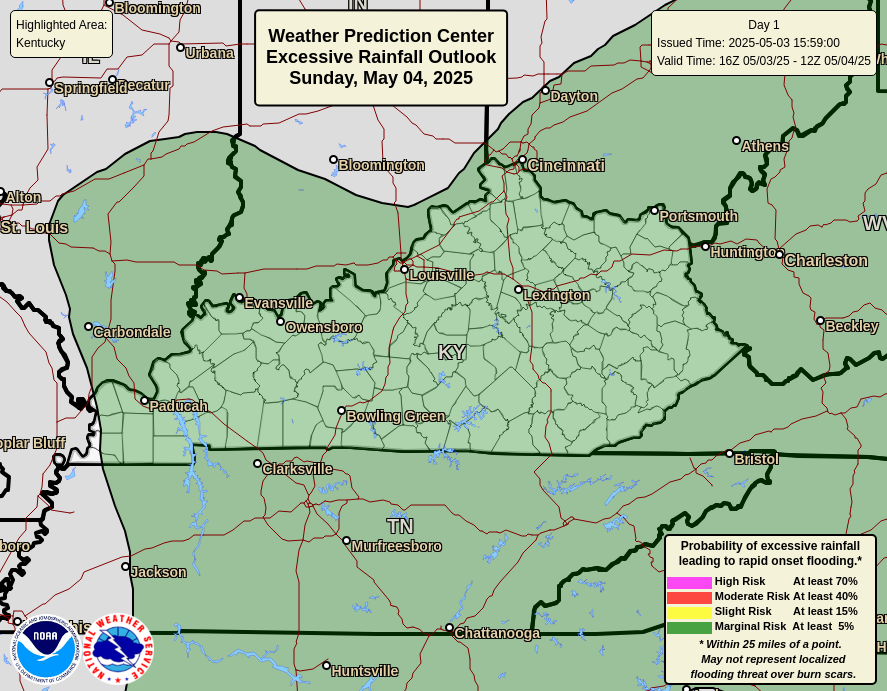
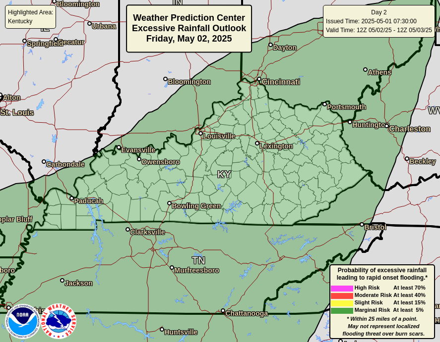
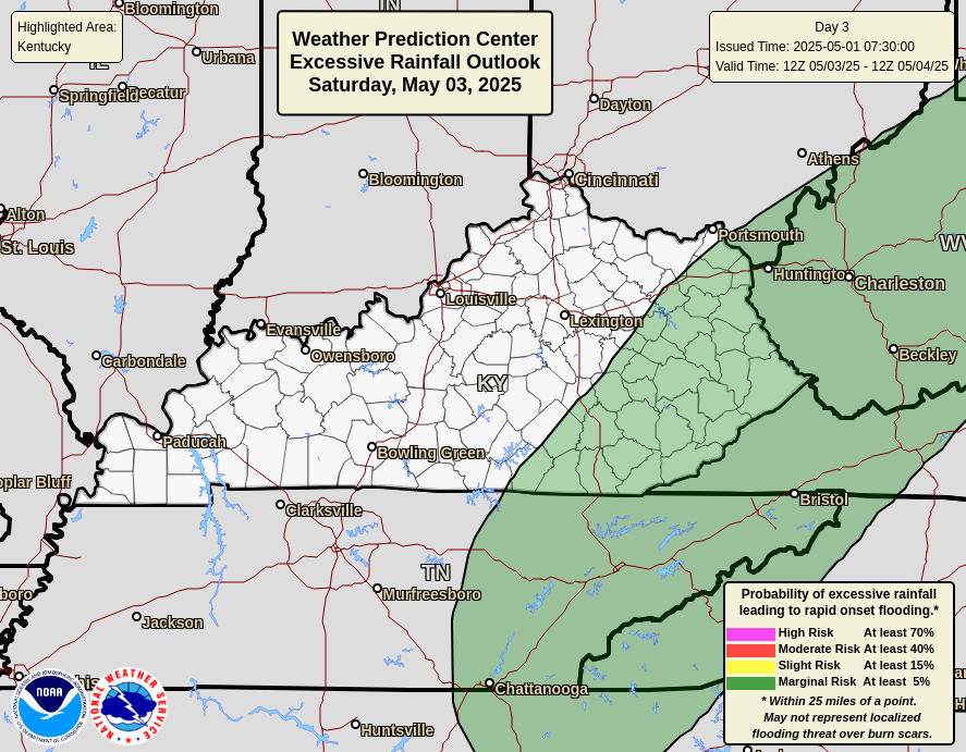
The Weather Prediction Center is highlighting the heavy rain threat over the next 3 days…
Today
Tuesday
Wednesday
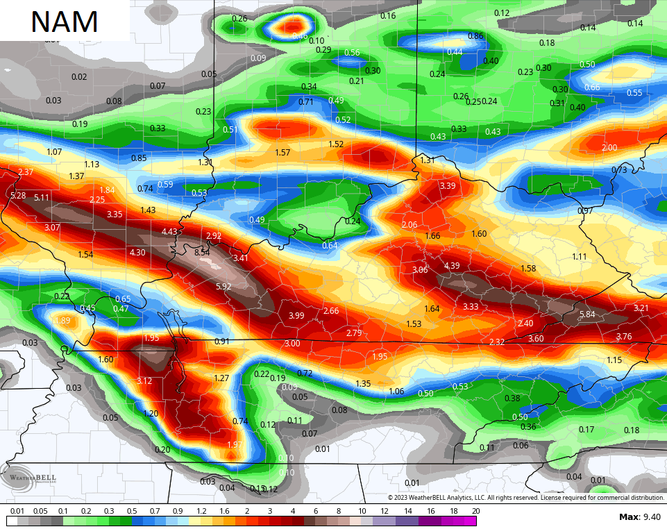
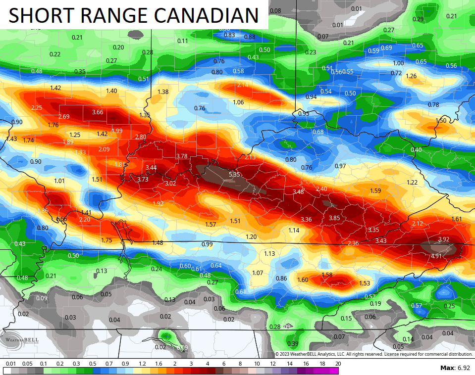
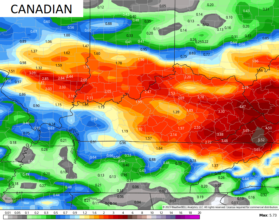
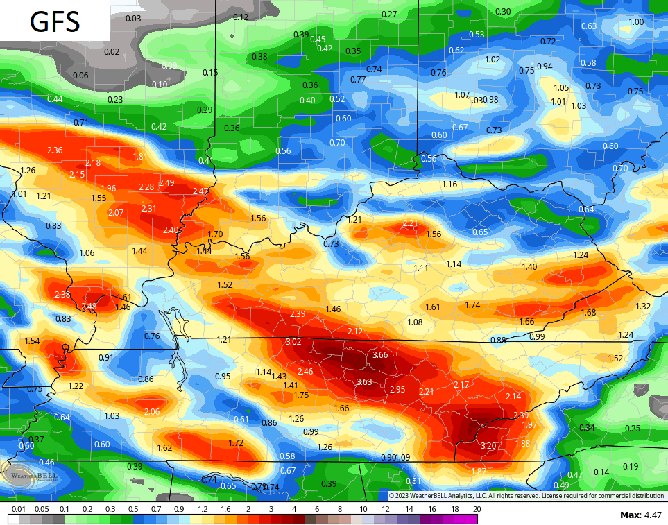
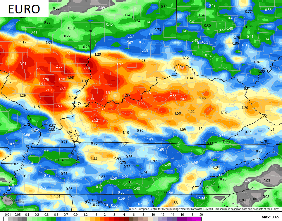
The models are having a tough time with figuring out exactly where the corridor of heaviest rains will fall and some of the models have some eye opening totals. Here’s what they’re seeing now…
The rain moves out by the weekend as that deep trough digs into the eastern half of the country…
Cooler than normal temps are likely this weekend into the first part of next week.
Here are your tracking tools to start the week…

Current watches

Possible Watch Areas

Have a magnificent Monday and take care.

Thanks Chris. Yesterday, the skies were an ugly shade of gray because of the Smoke again in our atmosphere. My Asthma condition got worse, but it’s better now. Elizabethtown, not too far from where I live had an Air Quality rated unhealthy. This bout of Canadian Wildfire Smoke has moved out of the area, and hopefully won’t return for a long while.
Rainfall prediction are being kept in my local forecast, but only to disappoint on what falls in my area. This precipitation trend in my area has been going on for I don’t know how long. Hope it changes soon as we are entering the driest time of the year. Maybe we will have a cold pocket of air aloft sometime this week and receive one of those heavy Rain / showers the weather models are predicting ?
I hope they get this fixed Joe D from BG :
https://www.weather.gov/lmk/bwg_missing
As near as I can figure, Schroeder, the communication issue is between the local equipment (which is working), and the NWS Louisville office. Both Mesonet sites, which update more frequently and with greater accuracy, are working normally.
Air quality in the BG area is currently Ungealthy, with Dust & Dander listed as Very High. Some very light rain in the area right now (0.03″ since midnight).
Joe, glad the issue has been rectified with the NWS in Louisville for Bowling Green. Most likely a computer problem.
We have a rain / shower going on now, but very little rain has fallen. Earlier this morning it was quite a rain / hail producer over and around Saint Louis. The ridge to our South is weakening the storms as they move east. What else could it be ? I really don’t want any severe weather with a lot of tree damage, so I guess it’s good in that respect.
I feel like the wildfires in Canada are just a permanent thing now…
I hope not Mark.
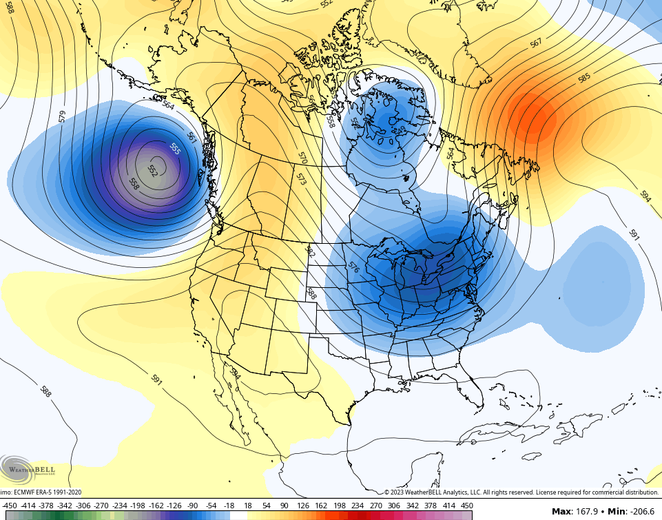
It is all about the jet stream.
Unfortunately we have to choose between two rubbish scenarios.
Cooler climate with smoke or hot & humid without smoke.
I choose the cooler climate option.
I will put a mask on if I’m worried about my health.
I choose hot and humid with clean air.
After a very wet and stormy first half of July, we’re finally drying out for at least a few days here in the Chicago area. No rain/storms are being predicted until Thursday afternoon for the area.
The pesky Air Quality Alert is in effect for the Chicago Metro Area until midnight tonight. Otherwise, it’s a pleasant mid-July day with temps in the upper 70s and a westerly breeze under hazy sunshine.
Very Smoky here too Mike, with hardy any Rain.