Good Tuesday, everyone. It’s an all too familiar setup across our region as rounds of thunderstorms target the Commonwealth. Some of these storms over the next few days may be strong to severe and put down enough rain to cause some local issues.
This is NOT all day rains that we are tracking and not everyone has issues. Just want to be clear about that. 😁
Let’s start with today’s low end severe weather threat. A few clusters of storms will be around early in the day with lots of dry times also showing up into the afternoon. We will have to watch for a complex of strong to severe storms developing to the west and northwest. This should roll into western Kentucky at some point and that’s the area where the Storm Prediction Center has today’s severe threat…

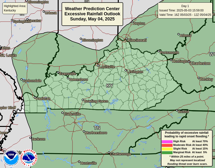
Any storm that goes up can produce too much rain to cause flash flooding with an increased risk across the west. Here’s today’s risk from the Weather Prediction Center…
Wednesday will feature another cluster or two of storms rolling across the region. Once again, there’s a low-end risk for severe storms…

These storms on Wednesday have a greater chance to produce some local high water issues farther east…
Watch those creeks and streams with any thunderstorm that goes up!
Scattered showers and storms linger into Thursday and early Friday before a HUGE dip in the jet stream takes place across the eastern half of the country…
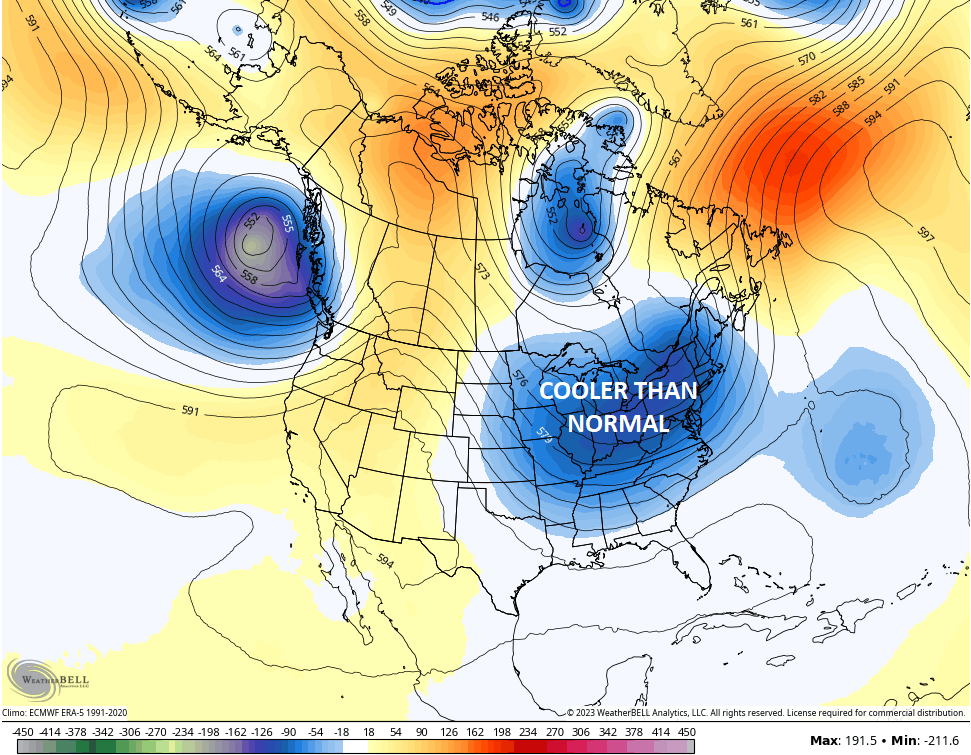
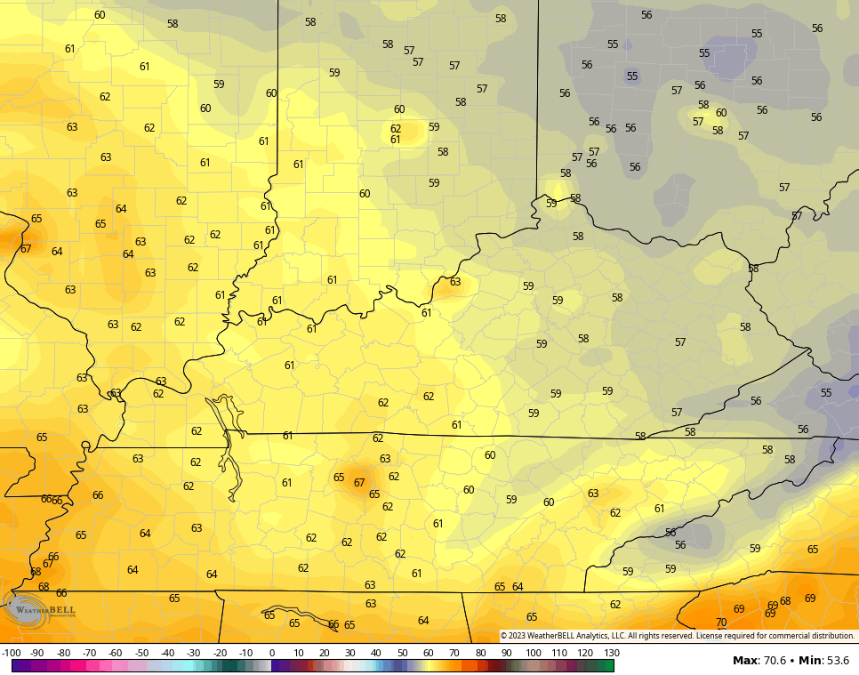
Much cooler than normal temps are likely this weekend and early next week. Lows over the weekend will likely hit the 50s…
That trough lifts out by the middle of next week with near normal temps likely. That said, the GFS Ensembles are hinting at another trough to end July and start August…
Here’s hoping this pattern continues through the fall and winter! ❄️😅🥶
As usual, I have all your tracking tools to follow today’s storms across the region…

Current watches

Possible Watch Areas

Have a terrific Tuesday and take care.

No. Here’s hoping the pattern stops until Fall/Winter.
Fall and Winter will likely depend on what will happen to the temperatures in the Pacific and Atlantic. If you are a fan of Snowstorms in the late Fall and Winter you would want a positive Pacific and a negative Atlantic.
Yesterday we had 0.05 ” of Rain / Showers with more Smoky / hazy skies.
If I could order fall/winter the way I wanted it…It would be something like this:
What you would expect from fall.. Some chilly days…some overcast rainy days…some nice days ..all the way up until around mid-dec (no snow) then around mid-dec it turns cold/snowy and stays cold/snowy until the end of Feb…then slowly warms through march…but March still having some cold..then cold completely gone by April..
I don’t like the idea of having a cold/snowy Nov/Dec… then the rest of the winter is warm and snowless.
I can’t believe August is almost here….
I prefer Autumn weather starting in mid- September through November. An Autumn that has clear cool days some days with rain followed by cold frosty mornings. A Winter with cold and not too frigid with frequent Snowstorms, but not crippling Snowfalls, and lasting through the month of March. A Spring in mid- April without the freezes, with warm April showers from time to time with mild temperatures through May. A Summer starting in early July with warm to hot temperatures and moderate rains from time to time and some cool nights. The above scenario actually happened in the years 1969 – 70 in South Central Indiana.
I am rooting for what favors snow lol. I can’t believe it’s just 3 months till Halloween. Didn’t one year we see some snow or snow flurries for Halloween??
Yes, On October 30th, 1997 we had 4 inches of Snow in Vanderburgh, county Indiana. Actually, we had to cancel a visitation trip to friends house in Kentucky. In the nursery the Snow on the flowering Mums was beautiful.
I simply believe in each season having its just due.
Aint that the truth they are due
With very unstable air in the area to the west of and along the southern third of I-65, including Warren County, plus cold air aloft and the presence of surface shear, means that strong storms are likely this afternoon and evening.
I notice on the radar that the heavy rains are being scattered by higher pressure capping the atmosphere and not allowing the warm humid air to rise and meet the cold air aloft to cause condensation. The mesonet shows this very well. Only rains for a lucky few.
Be careful, you have a strong chance of seeing a lot flooding rain over the next 36hours.
You are in the bullseye.
I would be very surprised if flooding rains happened in my area. The storms to the west will likely keeps the path of least resistance. My area at the present is capped with descending air. Western Kentucky more likely to receive the storms and heavy rains. A watch is already out for that area.
Here thunder in the distance, but zero rain. Western Kentucky ( Union County ) is in for a lot of rain and severe thunderstorms. Stay safe Winter Lover.
I got a recorded message on my phone for severe storms but we had some rain but I do believe the worst has went around us. It does that a lot but it also does that but forever a go lol when we had snow. You can watch it on radar it looks like it’s headed straight for Pikeville then at last minute it splits and half goes toward belfry and Williamson WVA and the other half goes toward Elkhorn City and the breaks I don’t know what causes it unless it has to do with the mountains.
Could very well be the mountains. We had about 0 .30 ” just a half hour ago in a garden variety thundershower. I think the worse was south going into Tennessee.
I think so too Schroeder