Good Wednesday to one and all. We continue to track waves of torrential rain producing thunderstorms across the region. These storms can still be strong or severe today with a greater severe threat lurking for Thursday. With all the rain, the flash flood threat continues to be elevated.
Let’s begin with today and hit the fast-foward button.
Our day starts with rounds of strong to severe storms impacting western Kentucky. This action is moving from northwest to southeast and should weaken some by afternoon. Elsewhere, we will only see scattered showers and storms.
The Storm Prediction Center continues with a low-end severe weather risk…

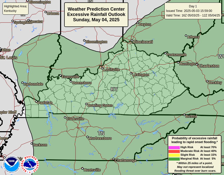
The biggest threat of the day is flash flooding across western and south central Kentucky. Several inches of rain will be possible early today and this is where the WPC is putting a spotlight on for the greatest flash flood risk…
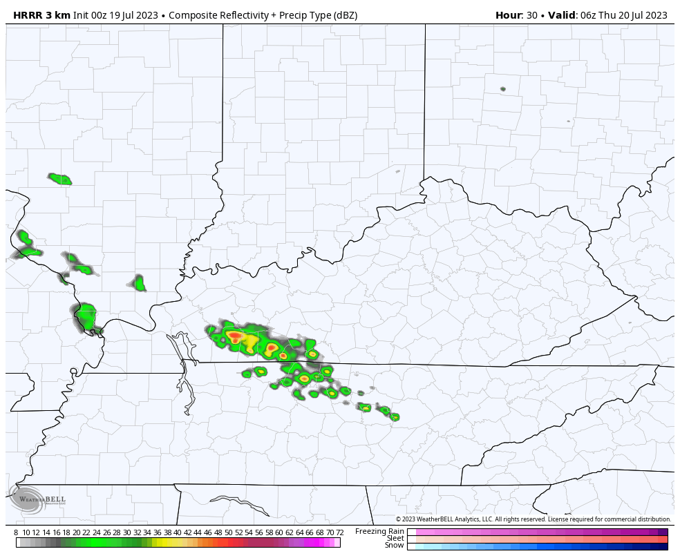
Additional showers and storms will then increase for Thursday as our cold front gets a bit more active. Watch the development of the Thursday storms on the future radar of the HRRR…
The SPC shows a better chance for Severe weather on Thursday than what we had out there today…

Damaging winds and large hail are the main players with the Thursday storms.
These storms will also produce torrential rains that can cause additional high water issues…
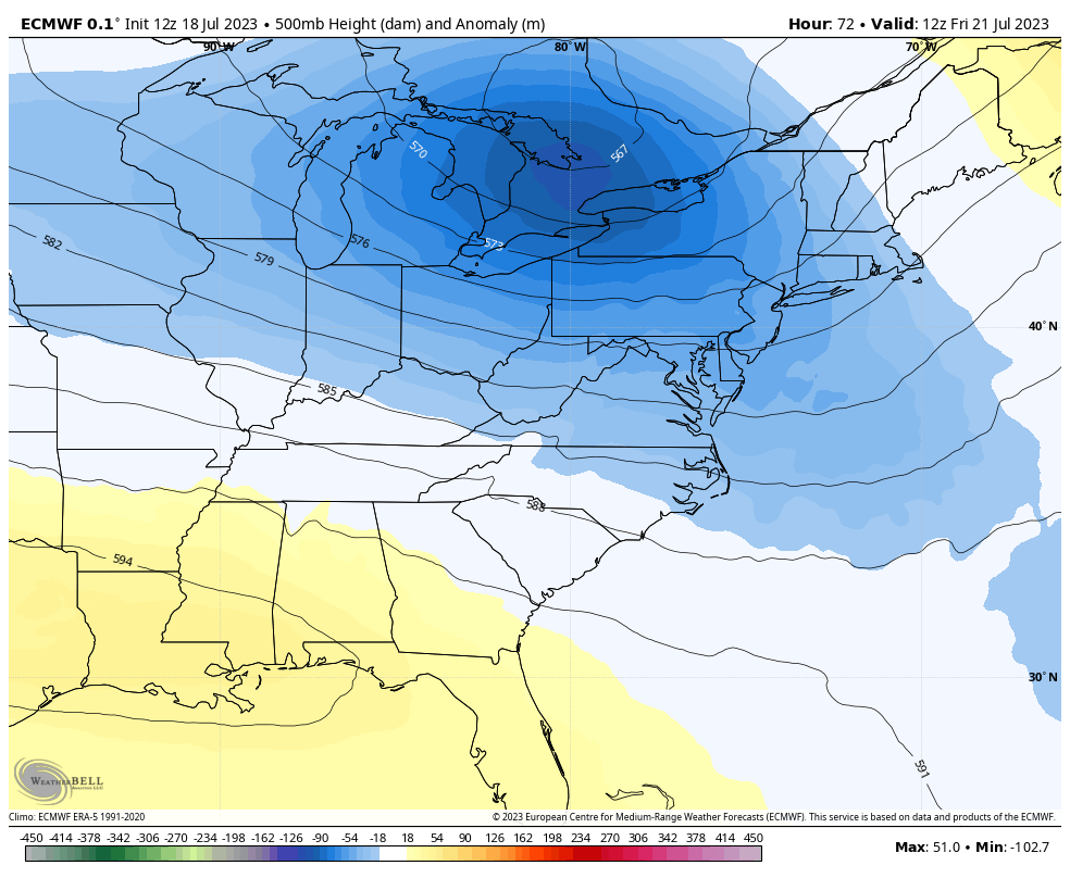
We finally start to push the storms to our south on Friday as that big trough dips in here for the weekend…
VERY pleasant temps will be with us this weekend and early next week. Beyond that, watch for more storms by the middle and end of next week.
I will update things as needed. I have you all set to track today’s rounds of storms…

Current watches

Possible Watch Areas

Have a wonderful Wednesday and take care.

Thanks Chris. Hoping the calm and pleasant temperatures pan out for this weekend, as my family is coming for a visit. Yesterday’s rain was about what I expected. According to the Mesonet we receive around 0.79″. Hoping tomorrow’s bout with severe weather doesn’t pan out ? Sick of this weather pattern. Ready for Fall type weather. Fall and Winter will be here before we all know it. Hopefully, we will have a true El Nino Winter with a lot of phasing between the Polar jet and the Subtropical jet to our southwest.
My lawn is a sponge. Enough with this rainy pattern…. Shewwww. Id love a few sunny days
I would think that it wouldn’t rain so much when we get into August and September. We really haven’t had that much as other parts of the state.
mother nature is putting a lighting show here in my neck of woods. Notice our day light is getting shorter it used to be daylight before 5 AM now its after 5AM as August rolls around will start noticing our evening daylight will be shorter., other words as each day goes by daylight is getting shorter.
Every time we have lightning here, I unplug the TV and the computer router. My house has been struck by lightning three times since I live here. No more if I can help it
Really some insane amounts of rain has fallen over extreme Southwest Kentucky. Some places over 9.00 and 10.00 inches of flooding rains as recorded by the Kentucky Mesonet. Well their drought is over.
I read about that rain unreal was it Mayfield?? I hope you nice weather for your family Schroeder.
Thanks Crystal. I hope so too.
I guess Jeff Hamlin has given up on his summer wish. LOL
I agree with Jeff. I always want Summer weather in the Summer months, but during this present weather cycle, we could have Summer weather when it’s Fall. This weather cycle will end someday, but no one knows when that will be. Every meteorologist is hoping this Winter there will be a true El Nino which will make Winter more interesting.
Nope
I knew you would show up!!
Wow! Yesterday wasn’t forecasted for severe wx here in Greenup Co, but we got hit hard!
Winds at least 60mph, we had huge branches come down and take out a big part of our fence, and the neighbors, across the street, had a mess also with trees and branches down. Highest wind I’ve seen or felt since the 2012 Derecho.
My body felt it coming but nobody mentioned that I saw. I could have overlooked the very small chance but my body had me on guard.