Good Friday to one and all. We have a cold front crossing the region today and it’s bringing some much better weather for the weekend. Temps and humidity levels come down, but we just can’t shake the chance for isolated showers and storms.
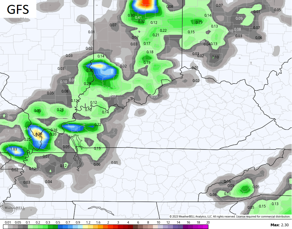
Let’s start this KWC update with what’s going on to end the week. The cold front works through from north to south today and pushes the widespread showers and storms well to our south. Still, some showers and thunder may show up across the southern part of the state during the first half of the day. Elsewhere, most are dry with just a small storm chance.
Here are your Friday radars to help you close out the week…

Temps today range from the upper 70s to middle 80s, making for another tame temperature day around these parts.
Pleasant air filters in for tonight and Saturday with lows by Saturday morning in the upper 50s and low 60s for many. Highs on Saturday are generally 80-85 with low humidity and a mix of sun and clouds. There’s the smallest threat for isolated showers and storms going up during the afternoon.
Sunday starts with similar temps and ends with low and middle 80s with a mix of sun and clouds. The models are hinting at a few late day storms trying to drift in from the northwest, especially across the western half of the state…
Temps early next week are still in pretty good shape but the pattern gets back to normal for the middle and end of next week. Some of the models are trying to throw insane heat into Kentucky and this is something they’ve shown time and time again only to see it fail miserably.
This overall summer pattern is hard to break and it’s one that has put our region in one of the few cooler than normal to normal areas across the entire world. With a super wet ground and green and lush vegetation, big time summer heat is typically hard to come by.
One thing to keep an eye on for next week is the potential for clusters of storms to roll in from the northwest around the core of the plains heat. The models vary with where to put this corridor…
Have a fantastic Friday and take care.

That western KY rain was insane. I can’t believe a state record was set. When I was watching the radar training over the same places it reminded me of Sept 2006 here in Lexington.. At least I “think” it was Sept 2006.. I know it was Sept because I remember thinking Sept is so dry usually.. The radar then was oriented in the same northwest storms sliding southeast and redeveloping over the same place.. Only I think our total here was like 7 and a half inches or something like that. It also happened at night. I think it was like midnight to 230 am if I’m remembering correctly. I remember feeling like it was never end. I think this included Frankfort too. I’m not sure, but I think the brunt of the rain fell in the western 1/2 of Fayette including downtown and the airport
Mark, I was thinking the same thing while watching that radar, and for me it brought back memories of May 2011, when Bowling Green recorded a 2 day total of 13.2″ of rain. Several times during that period the rain fell at a rate of 2½” per hour. It was like a fire hose on a flat rock!
I think I remember that vaguely… Obviously it will be much more of a memory if you actually experience it as opposed to watching it on TV or hearing about it. I got curious and I’m amazed I was able to find the data on this on the NWS.. Looks like it was the night of Sept 22. It was one event but it happened during a two day recording period. It must have started around 11pm..On Sept 22, 2006, 1.74 inches of rain fell then on Sept 23, 2006 (after midnight) 4.76 inches fell..If I were to guess it started maybe 11pm on the 22nd then ended around 230am on the 23rd..
https://www.weather.gov/wrh/climate?wfo=lmk
The pattern will soon break. Time for some 90s! 🙂
You must be living in a cave Jeff, we’ve had temps in the 90’s.
Incorrect. I know we’ve had 90s, but I want more.
Last Friday we had a high temperature of 91 degrees. The hottest temperature of the Summer so far. As long as it doesn’t reach a 100 degrees Jeff, I’m good. The models are all trending warmer. It may very well be a backloaded Summer ?
It is really not about the temperatures as much as it’s about the humidity.
Hot temperatures with low humidity is feasible.
It’s confusing about the feel like temp…(heat index)
Say you’re in Arizona and the temp is 110 (but very low humidity) so the heat index might be 108… and then go east and it’s 95 with very high humidity and dewpoint and the heat index is 108… So both places feel like 108… and yet one’s dry and the other one is oppressive… so even though the heat index is the same… it doesn’t feel the same at all
I’m sure we will have more of the 90’s temps with dog days coming in August
The highest rainfall total I’ve seen was 14 inches in a 48 hour period, which occurred in Vanderburgh county, Indiana back along time ago. My county of Taylor has only seen the normal amounts of rain this month at 2.77 inches. The ground here is not wet and the foliage is not lush. It’s beginning to look like late Summer. I think the hot weather will happen and continue possibly into the Autumn months ?
Also the dew point temperature is a factor when considering comfort.
Also the dew point temperature is a factor when considering comfort.
My computer is not working right or it’s my brain LOL……
Some post today do not have a reply underneath. Why is that ???