Good Wednesday, everyone. We are watching another stormy setup taking shape across the region as a boundary slows down and hangs around. This will lead to waves of showers and storms through the upcoming weekend and into early next week.
This is NOT wall t0 wall rainfall during this period and you will have a lot of dry times, but when it rains, it will put it down in a hurry.
Our Wednesday starts with temps back into the 50s for much of central and eastern Kentucky. Afternoon highs are back in the 80s with a mix of sun and clouds. Those clouds may produce scattered showers and storms in the west and there’s even the low-end chance for a few strong or severe storms there.
The Severe Weather Outlook from the Storm Prediction Center has the far west in the risk…

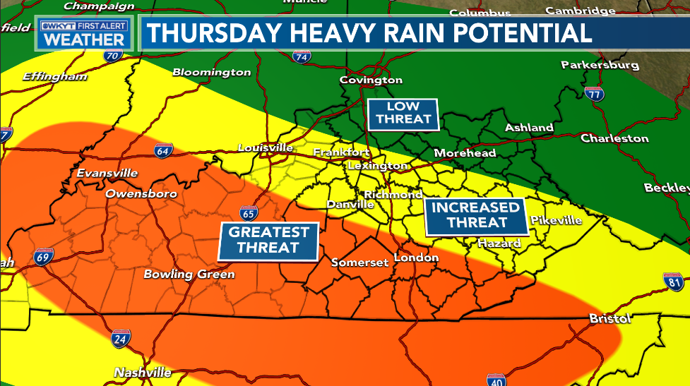
Rounds showers and storms then kick into high gear tonight and Thursday. This action may put down torrential rains that can produce local high water issues. Here’s the area currently most at risk for seeing this corridor of heavy rain…
More in the way of showers and storms will be scattered throughout the region on Friday and into the weekend. Showers and storms will likely increase a bit by Sunday and Monday as a cold front sweeps through the region.
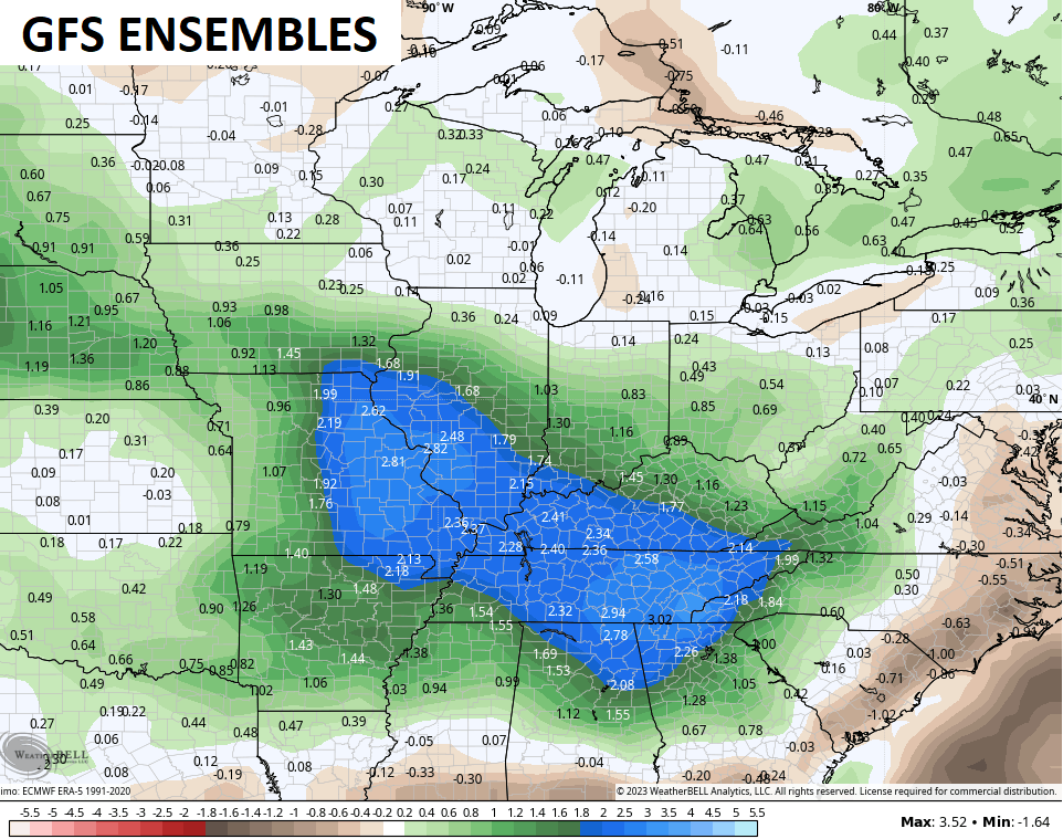
The overall look of the pattern for the next two weeks is likely to include above normal rainfall. This is something the Ensembles see well…
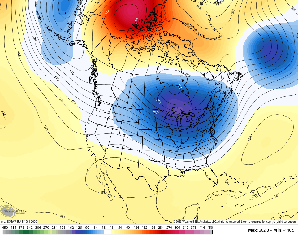
The other big takeaway from this pattern is we keep the overall tame August temps and likely go right back to below normal for much of next week. This is a massive trough developing…
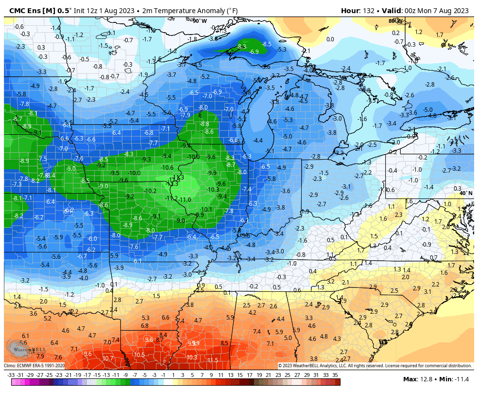
Check out the below normal numbers…
Some new seasonal models are out and look long range into the winter ahead. I’ll be breaking those down in the days to come.
As always, I leave you with your daily dose of storm tracking tools…

Current watches

Possible Watch Areas

Have a wonderful Wednesday and take care.

The winter models won’t be right.
Thanks Chris. Sure looks like it may rain in my area now compared to yesterday’s radar returns. A chance exist in my local forecast through Friday. We shall see how this all pans out.
It will be interesting to see what long range forecasters are predicting how the Fall and Winter may turn out ?
Looks like the rain is going to stay west of my location today. I actually could use some rain. It has been dry at my house.
The winter models say colder but dryer winter….I’m just following the script for el nino winter here. These are the same type of summers from the mid 80’s. Thunderstorms throughout the summer months with rain every week or so. I’ll take it compared to the summers I grew up with in Peking.
If that comes to fruition then I would prefer the winter temps. to be above normal.
It is snow or bust for me.
Just read the Farmers Almanac winter forecast it states be cold and snowy across the country. Depending on how EL Nino plans out
July 2023 finished 0.3 degrees above normal at Chicago’s O’Hare Airport, with an average temperature of 75.7 degrees and seven days of 90+ degree high temps. It was the seventh wettest July ever, with 7.61 inches of rain.
Midway Airport received 11.28 inches of rain, the wettest July since 1928 there.
https://weather.gov/lot/July2023