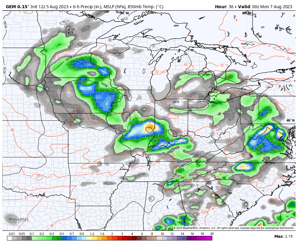
Good Sunday to one and all. Rounds of strong to severe storms will rumble across the region today into Monday. While not a washout, we are looking at some heatlhy rains when the storms do rumble through. This is all part of a very active setup that really doesn’t look much like early August.
A few rounds of storms will sweep across the state today and some of these may be strong to severe. The Storm Prediction Center has a Slight Risk out for much of the region…

Wind damage continues to be the main threat from any of these storms going up today or tonight. Here’s the full breakdown of the individual threats on the day…
DAMAGING WIND

LARGE HAIL

TORNADO THREAT

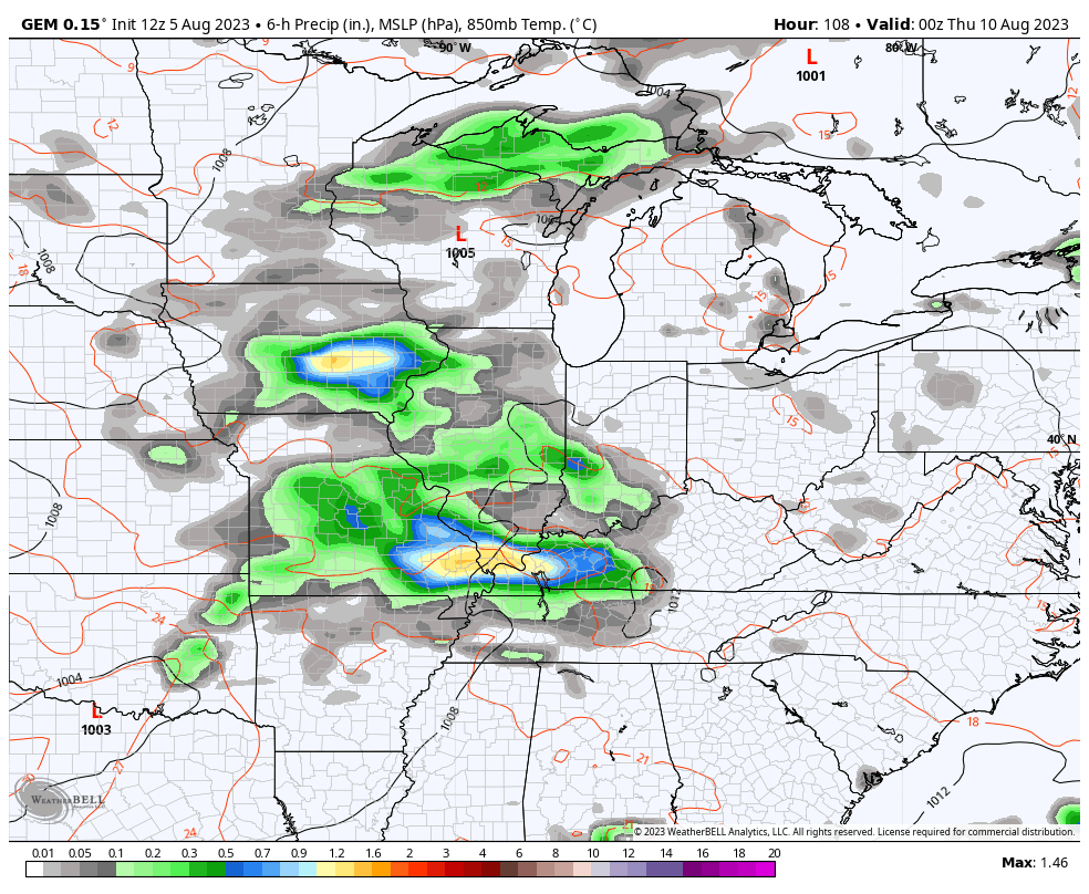
The overall severe threat for Monday then concentrates farther east for Monday with central and eastern Kentucky being in the Marginal Risk to Slight Risk area…

Here are the individual severe weather threats for Monday…
DAMAGING WIND

LARGE HAIL

TORNADO THREAT

This unusual setup comes from an unusual pattern featuring low pressure spinning into the Ohio Valley over the next few days. This low drags a cold front across the region with wrap around showers even possible by early Tuesday…
Below normal temps will be noted with along and behind this system.
Two more systems are set to follow with a cold front that can bring more strong to severe storms in here late Wednesday and Thursday with another cold front by late next weekend…
Look at the rainfall numbers over the next week and change from the Canadian and EURO…
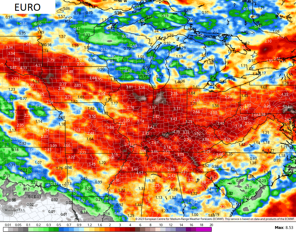
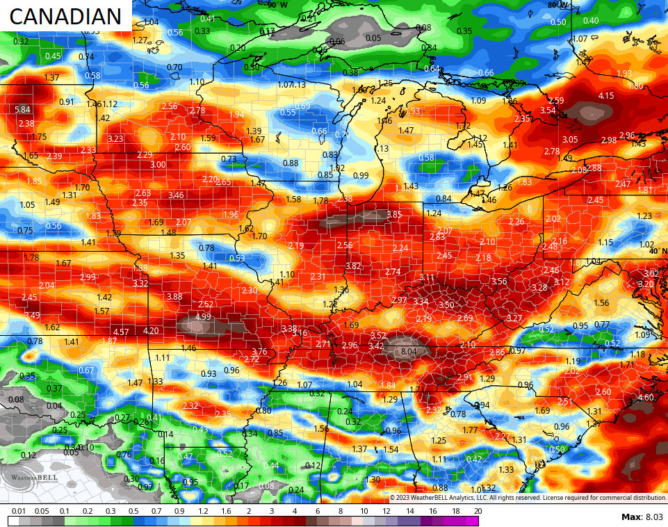
A pattern this active is not very common in early August but it’s what happens when the jet stream takes such big dips into the country.
On a related note… The GFS is a really really bad model right now and has been most of the summer. It simply cannot see rain and thunderstorms because it’s too busy showing phantom heat waves. End of rant. 😎
Here are your storm tracking tools for the day…

Current watches

Possible Watch Areas

Have a great Sunday and take care.

All the models and ensembles have not been entirely right this Summer.
This article explains the whole meteorological cycle with all models and ensembles used in short term and long ranged weather forecasting.
https://www.worldclimateservice.com/2021/08/23/probability-vs-anomaly-forecast/
On the severe weather maps as you can see all of Kentucky is only in the slight risk today. Tomorrow’s maps have almost all the Appalachian area in the enhance risk. This may be the beginning of a precipitation pattern change. Don’t know.
Much of the wind action we’re seeing this year may be due to abnormally warm water temperatures in the northern Atlantic and Pacific, which enhances ridging over Alaska and Greenland, and causes troughs to drop into the central US. It’s sort of a Summer version of an Omega Block, with the pressure difference amping up winds. In Winter, this setup could bring periodic cold air outbreaks into our region.
Omega Block is what we had in the very, Snowy, yet not that cold of a Winter in 1969 – 70. The Summer was mild before that with not that much rain, and I remember Hurricane Camille a Category 5 that hit the Gulf Coast States in August 1969. Also we had a weak El Nino in the Winter 1969 – 70. I was senior in High School in 1969 – 70 and living in South Central Indiana.
This summer kinda reminds me when growing up as a kid lot of thunder and lighting storms. Just my opinion I think the patter will change once that heat dome high pressure breaks that’s been setting over Texas all summer
If we have El Nino, especially a weak to moderate event, the Southeast Ridge ( Bermuda High ) will not be so dominate as last Winter’s La Nina event. Strong to very strong El Nino events tend to over activate the Subtropical jet stream and we end up with a very mild and rainy Winter. This happened in the Winter 1982 -83. Hoping for a weak El Nino this Fall and Winter as this allows the Polar jet to merge with the Subtropical jet over the Southern Rocky Mountains bringing a train of Snowstorms into the Ohio Valley.
Looks like my area is the greatest risk of severe weather Monday.,Especially for wind. I hope no one loses power. That looks like some strong wind possibly. Schroeder I hope for snow this winter too I guess we will all wait and see. Chris looks like you may get very busy the next couple days more than usual. Glad to have the blog to go to.
I think it’s more South of your area Crystal. Always be prepared though just in case.
The key determining factor for an El Niño that can bring Winter weather to Kentucky, is if we see the warmer than normal waters off the Pacific coast of South America positioned further to the west than they have been. The current SSTA chart shows that that scenario is developing, but it will need to maintain or expand its presence over the next few months.
The other key factor is ridging that pushes the polar jet further to the north of Alaska, which would produce a corresponding trough over Canada to channel cold air into the Plains and Midwest.