Good Thursday to one and all. Another September looking and feeling cold front is ready to push through the region tonight and early Friday. This brings another round of nice temps before we turn up the heat into early next week. How long that heat sticks around has a lot to do with the tropics.
Let’s begin with our September cold front working in tonight. The weather ahead of this is really nice today with upper 70s and low 80s as winds gust up and a few clouds increase. This front is moisture starved but should be able to fire up a broken line of showers and storms with it during the late evening hours. This pushes through very quickly overnight.
Here are your radars to follow this finger of evening showers and a rumble of thunder…

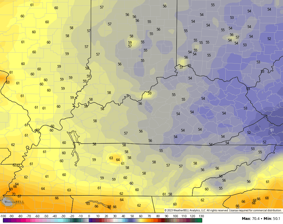
The air coming in behind this is fresh and feels like mid to late September. Lows by Friday morning are in the upper 50s to low 60s with many areas staying in the 70s for highs on Friday. This sets the stage for amazing weather for high school football fans as we kick off the season Friday evening.
Lows by Saturday morning may drop into the 50-55 degree range for much of central and eastern Kentucky with 50s all the way into the west…
Saturday is another pleasant day with highs mainly 80-85 degrees. From here, we see the heat ridge ballooning into the region from the west…
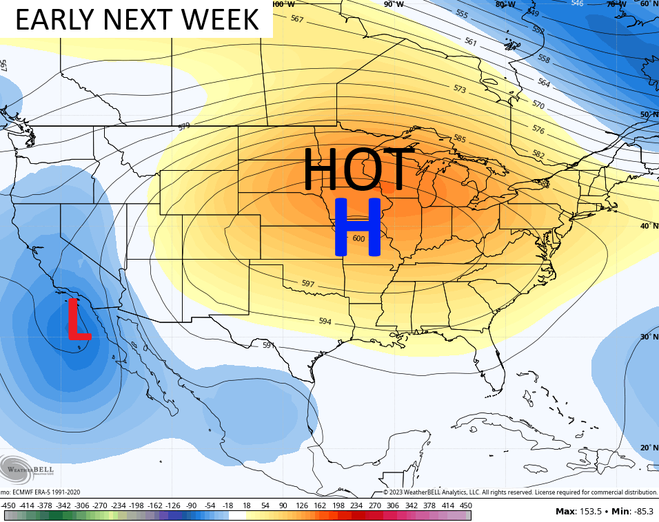
That spells a period of 90-95 degrees across the region for the first half of next week.
The staying power of that ridge gets a boost from an unlikely source… the track of a developing hurricane in the east Pacific. If you look closely enough at the map above, you see the lower highs along the California coast. That’s because the leftovers of soon to be Hurricane Hilary may very well impact southern California. There’s even the chance for a landfalling Tropical Storm not too far from Los Angelous. Yes, you read that correctly.
Check out the forecast track from the National Hurricane Center…

The forecast models are seeing this threat more and more…

That’s nuts to see and that system will keep that ridge from being pushed back into the west a little deeper into next week. The remnants of that may lift up and around the ridge and could get all the way into the central or eastern part of the country.
The lid on the tropics is coming off with two systems in the Atlantic and a possible system developing in the Gulf of Mexico in the coming days…

The models are seeing the Gulf threat a little better with each run. They develop a system as it works out of Florida on a westward trek through the Gulf…

Those two systems in the Atlantic are ones to watch out for from late next week into the following week.
Make it a great Thursday and take care.

I give the potential tropical system in the Gulf a much better chance for development than the Atlantic systems. Low and upper level steering winds in the central Atlantic will tend to push those storms towards the north, and the increasing influence of El Niño is supporting shearing winds in the eastern Caribbean, which will tend to weaken tropical system. Spaghetti models have been picking up this trend for several days running.
Regarding the warmer than normal waters off the west coast of South America, they are still not detecting a shift in that area towards the west, which, if it happens, would greatly improve our Winter weather chances.
Joe, I am beginning to believe this forming El Nino is not what us Winter Snow Lovers want to hear. I get that impression from NOAA with each question I ask them. It’s the equal chances which translates to ” we don’t know. ” We will probably have our typical Winter with the question it may or may not Snow ? I am waiting on the Old Farmers Almanac forecast for where the most Snow will fall in the Country this Winter. Last Winter these Folks predicted a Snowy Winter and they were correct for the Northern 1/3 of the Country. The Country as a whole receives more Snow Storms when La Nina is dominating.
I agree. The best “flavor” of El Niño is one where the SSTA chart shows the warm water farther off the coast of South America, but the current chart shows that the warmest waters are closer to shore. Also, I believe that the storm track position is critical. During the Winters of 2014-15 and 2015-16, Bowling Green received over 2 feet of snow during each snow season, while the Northeast and Upper Midwest were way below normal, due to a much further south storm track. The biggest dips in the storm track occur when strong ridging is in place over Alaska and Greenland, which is what we’ve seen over the past 2½ years, but they occurred during La Niña years. That storm track in an El Niño year could make this coming Winter very interesting.
Excellent explanation Joe. NOAA has been giving me the ” we don’t know ” s*** . You would think with the Super Computers they have there they could do a better job for meteorologist and the public. Back in the 1970’s when they started NOAA weather radio 24 /7 the information was great and accurate. I remember back in the Fall 1976 they gave the Fall and Winter long ranged outlook and it read a ” Colder and Drier Fall and Winter ” 1976- 77 ( a weak El Nino year ) and they nailed it to the T. Times have changed for the worse and better since then.
I am surprised that a storm could actually form in the gulf. Due to the fact that a strong high has been sitting in the gulf for months.
I believe the center of higher pressure is north of the Gulf and the ridge is moving this way with maybe a longer than we want Heat Wave with no mention of any rain in the next seven days. Typical late Summer weather here in Central and Western Kentucky.
No mention of any cyclonic activity in the Gulf as of yet by NOAA, but there’s some activity off the coast of Africa.