Good Friday, folks. It’s an absolutely awesome weather day and this awesome continues into much of the weekend. After that, forget about it because some heat sets up shop across the region into next week.
Highs out there today are mainly in the 70s with low humidity levels. A mix of sun and clouds will help make this about as good of a mid-August weather day as you will ever see.
Lows tonight and early Saturday are likely to be the coolest since May. 50-55 will be common across central and eastern Kentucky with an outside chance for some upper 40s to show up in the traditional cool spots. Some of the models show this potential…
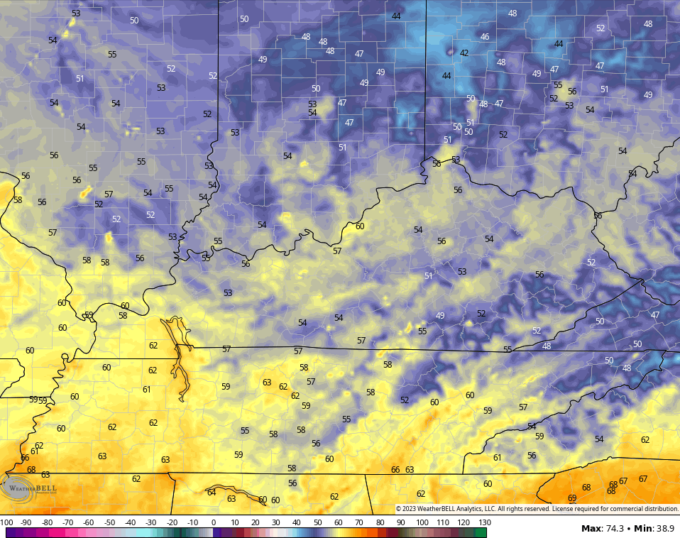
Saturday is another awesome one with low humidity and highs from 80-85. Lows reach the 50s again Saturday night and early Sunday but temps take off from west to east later in the day. Much of central and eastern Kentucky will be mid to upper 80s with 90 in the west.
The heat ridge then flexes into the first half of next week…
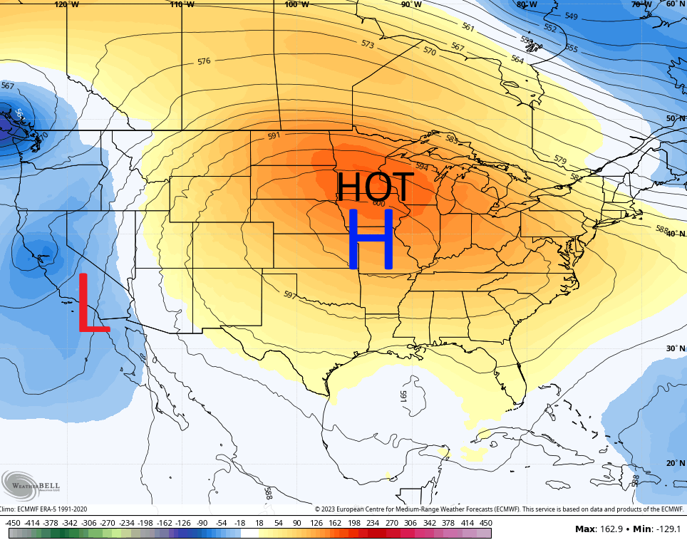
Highs of 90-95 engulf much of the region but humidity levels don’t look especially high during this time. Still, this may be the hottest stretch of the entire summer for our part of the world.
Keeping this ridge in place is what’s heading toward California and that’s a rare tropical hit. We have Hurricane Hilary churning away in the eastern Pacific and this is heading north and may still be a tropical storm as it moves into southern California this weekend…

That’s amazing to see and something that is super rare. Who would have thought California would be the first state impacted by the tropics this season. Crazy times, folks.
We are also watching for potential development in the Atlantic and down in the Gulf of Mexico…

The system in the Gulf is forecast to develop and roll toward the west with a potential Texas impact next week…

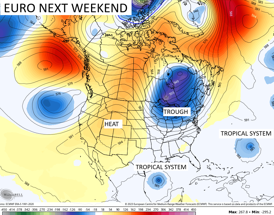
The other systems in the Atlantic will have to be watched for possible US impact late week into next weekend, but the models are a long way from figuring all that out. A snapshot of a few of the models for next weekend show the heat going back west with a trough trying to get into the eastern half of the country again. The Euro shows one of those in the Gulf with another one well off the southeastern coast…
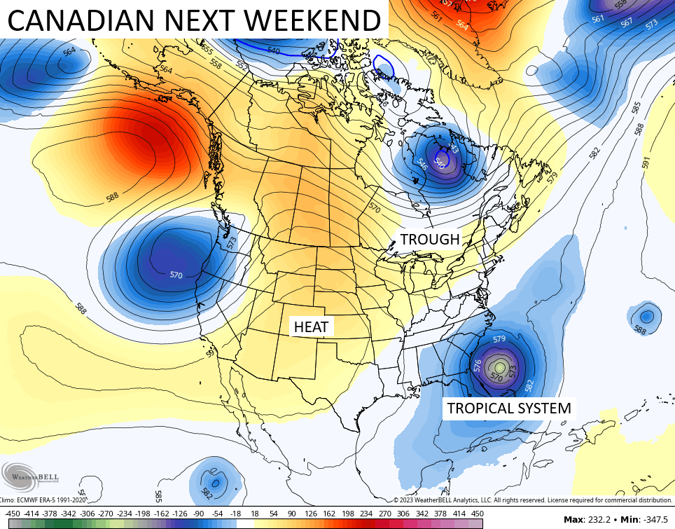
The Canadian has a much bigger tropical threat off the southeast…
Lots of model mayhem will be noted over the next few weeks as the tropics stir things up even more.
Have a fantastic Friday and take care.

Bring on the heat! 😉
Back loaded Summer like your predicted earlier Jeff. Good job and enjoy. Hoping my aging Air Conditioners hold up through the duration of the Heat Wave.
I hear you on the air conditioners mine is getting up there in years too. Jeff gets his heat next week. I wonder if the smoke from the Canadian fires will make it down to Ky? I read they evacuated a whole town in Canada.
To be fair, I’m not rooting for any drought or fire conditions. I’ll even be ready for fall soon enough. 🙂
Oh I know you aren’t Jeff. I like Fall too.
I just hope we have nice, cool and clear skies with plenty of foliage color, but it may be late ?
Smoke, maybe in the lower layers of the atmosphere, due to the air under high pressure descending. I don’t understand why that’s continuing to burn in areas of Canada. Letting it burn on purpose ?
Thanks Chris. I wish that abnormally large Dome of High Pressure was farther West. I mean along the Coast of California to Alaska. That’s where it set up shop in the weak El Nino years of 1976 to 1978. If this amplified High Pressure holds closer to our area it will decrease our chances of having a cool Autumn and a Snowy Winter, but weather changes and I hope it does. I think now most of the Snows this Winter will be farther East and Northeast of our area. Eastern Kentucky has the best chances in my opinion now. With the Tropical Atlantic exploding with Tropical Cyclone activity this morning, I have really discounted El Nino until later in the Winter. More likely in the Fall and Winter 2024 – 25. Again in my opinion.
Hurricane Hilary will not be able to maintain her strength once encountering the cooler waters off the Coast of California. Maybe a good rain maker at best. The Atlantic does not have the cooler coastal waters. Hoping none of those make Landfall.