Good Saturday and welcome to the coolest day we will see for a week. We’ve had one amazing run of September temps over the past week as part of what’s been a tame temperature summer, but things are changing. A more typical hot setup is on the way for the week ahead.
Temps this morning are in the 50s for most of the state and I can’t even rule out the first upper 40 in the traditional cool valleys. Temps this afternoon reach 80-85 for most with low humidity and plenty of sun.
Sunday starts to toast it up with 90 in the west and mid to upper 80s central and east.
From there, most of next week will feature highs in the 90-95 degree range, which is above normal for this time of year. This heat is nothing out of the ordinary in a typical summer around here.
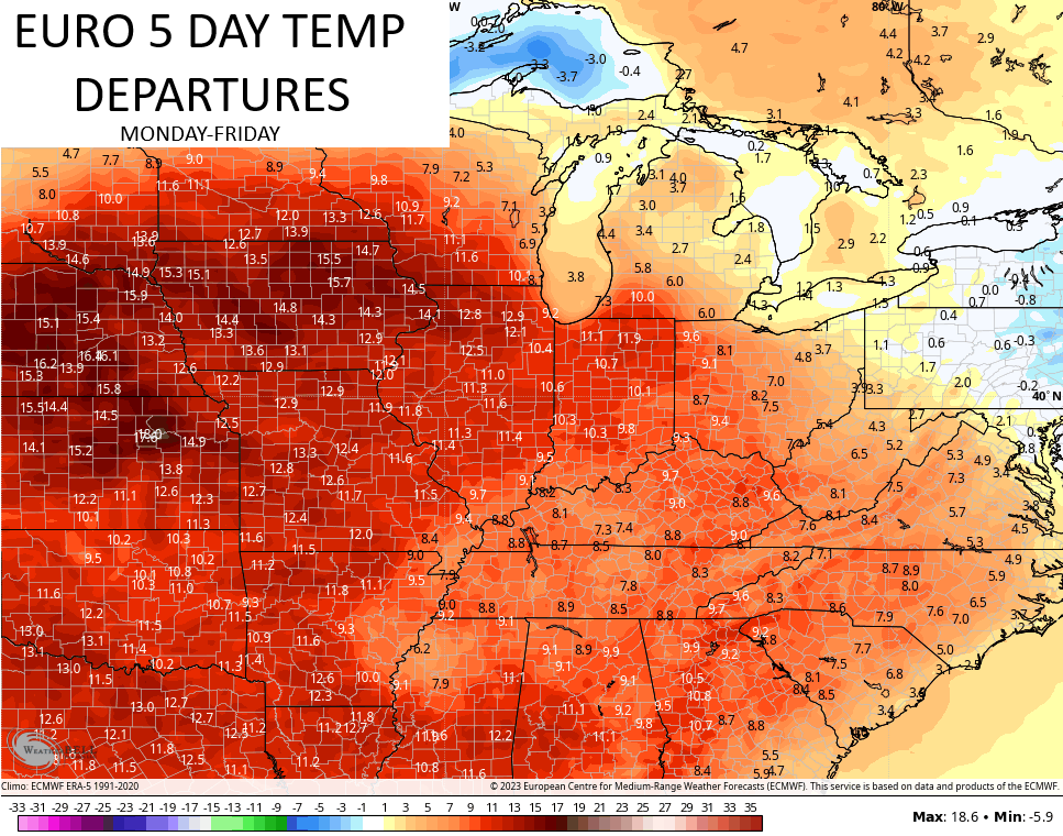
The core of the heat stays well to our west and you can see that well on the EURO showing the temp departures next week…
This heat ridge is holds steady in part because of a rare event in the west. That’s where what’s left of now Hurricane Hilary heads toward southern California…

That may very well be a Tropical Storm as it moves into SoCal, marking the first time that’s happened since 1939, I believe.
The remnants of Hilary then get picked up and work around that heat dome. Check out the track from the Hurricane Models…

That’s pretty insane to see and it’s very possible some of that moisture gets into the eastern half of the country late next week or weekend.
This is just one of many systems the National Hurricane Center is tracking with 3 in the Atlantic and one coming to the Gulf of Mexico…

The first system that may impact the country is the one going into the Gulf. The models show this essentially bowling due west toward Texas early this week…

From there, the systems in the Atlantic will be the ones trying to flex. Any potential United States impact remains to be seen.
Overall, those systems will impact the overall pattern across North America.
One thing that looks fairly certain is that the heat ridge gets dismantled fairly quickly next weekend with a trough coming back into the east for the final week of August. The EURO goes through August 28th…

The EURO Ensembles go all the way through the start of September and see the trough…

Have a great Saturday and take care.

Question? Is this heat all next week going to be a high dewpoint humidity heat? Or just a dry heat? I dread it honestly…
I dread it too but we have been lucky this year.
High temperatures in the upper 80’s and mid 90’s with dew points in the 70’s is what’s in my local forecast, but for Lexington and points East and Southeast not soo much. Hopefully we will get the cool weather back next weekend. The troughs don’t seem to come very far South. Staying North and East of our area. Hope this changes next month.
https://www.cpc.ncep.noaa.gov/cpc_key_messages/CPC-Key-Message-latest.png
The crop harvest may be earlier this year, with the lack of any rainfall for sometime to come. We have normal moisture in our soils here in Maple, but we have miss most of the good soaking rains this Summer. After this week I will definitely be ready for Autumn type weather. Really I’m ready now !!!
Long range forecast is not showing a drip of rain.
We are approaching our driest time of the year, with October being our driest month on average, but between now and then we should have some rainy days.
Seven day forecast for Bowling Green:
Sunday: 96°F, Monday: 98°F, Tuesday: 99°F, Wednesday: 99°F, Thursday: 104°F, Friday: 100°F, Saturday: 89°
Thursday’s forecast high would break the record of 103°F, set in 2007.
Wow Joe hope you don’t get that high. Why does it seem that area is always warmer?
I’ve been here in Maple for 15 years and the highest temperature has been 96 degrees, but there is only one single lane asphalt road and no houses, ( except ours ) just all hills, trees and a breeze. Nearest Neighbor a mile away. Mid 90’s no 100 + temperatures in the local forecast, but this huge high pressure is the most enormous I’ve ever seen on the US weather maps. Could very well destroy what could have been a very nice Fall, if nothing changes. I have noticed that weather patterns these days do not change very quickly as they use to. Must be something to this Climate Change ? Don’t know.