Good Tuesday to one and all. We are in a typical August heat spell across the Commonwealth, and this continues through the end of the week as the core of the heat stays to our west. We can still get pretty toasty, though, before a cold front crashes in this weekend.
The NWS put out Head Advisories and Excessive Heat Warnings for central and western Kentucky on Monday and they really didn’t come close to verifying. Heat Advisory criteria is for heat index of 105 or greater for 3 consecutive hours. Excessive Heat Warning criteria is for a heat index of 110 or greater for 3 consecutive hours. These areas ranged from the mid 90s to low 100s at the peak of the Monday heat. Many school districts followed these forecasts and cancelled or delayed outdoor activities because of the excessive heat that didn’t verify.
The GFS temp forecasts have been beyond absurd and we have pointed this out numerous times. That said, even the GFS is starting to see more realistic solutions in the coming days.
We have a backdoor front working through the region from the north and northeast today. This brings slightly cooler temps and lower humidity into central and eastern Kentucky today and Wednesday.
Check out the today’s Heat Index numbers from the GFS…
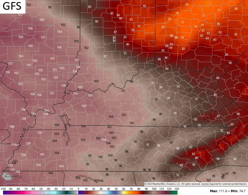
Folks, that just says it’s August. There’s nothing excessive about that and, instead, that’s barely into Heat Advisory criteria in the west.
The GFS brings the numbers down even more on Wednesday…
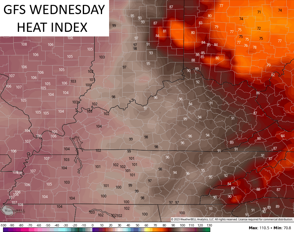
Again, that’s a pretty lame excuse for anything to be called “Excessive”.
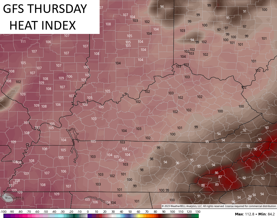
Thursday and Friday continue to look like the hottest of the week and summer and when Heat Advisories will be warranted for the entire state, but the numbers may still come up just shy of the 105 criteria for 3 straight hours.
100-105 should be noted for many Thursday…
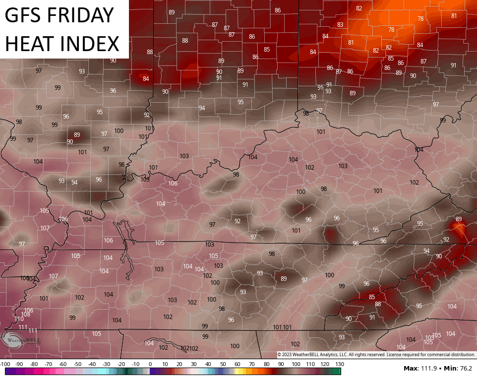
That continues into Friday along and ahead of a cold front that you can see crashing in from the northwest…
I can’t rule out some scattered showers and storms in the east in the coming days, but the greatest storm threat comes with the arrival of the cold front Friday night and Saturday. That will be followed by much cooler weather with the potential for some showers and storms developing into the middle of next week…

This comes as the models struggle with what would be Hurricane Franklin out in the Atlantic and an upper level system closing off in our region…
EURO

CANADIAN

I mentioned Franklin and that’s the system down in the Carribean right now. We have several other systems being monitored including the storm developing in the Gulf of Mexico…

This Tropical Storm is heading toward a date with the lower Texas coast today…

Check out the sat shot of this sprawling system…

It’s a good thing this thing waited until closer to land to develop because it’s a put together little system.
Make it a great Tuesday and take care.

Your verbal filleting of the NWS could be called unnecessary. I worked outside yesterday – all day. I was mostly with farmers. Henry County down to Jessamine County. In every setting the fact that schools were canceling practices came up. Not a single tough old farmer thought that was a bad idea. In fact, they were more concerned for the health and well-being of young people than their own. I realize you look at numbers on computer screens, and numbers rule, right? Well, sometimes we make decisions about our lives that depend upon factors other than just a number.
I AGREE 150 % Lexington Yard Guy !!!
Wrong to do that.
It was entirely necessary. criteria for weather advisories and warnings don’t care about your feelings or opinions. They are based on data. When they are abused to push a political agenda based on who is in the Whitehouse, it begins to become less trustworthy and the public begins to use it less. Your lives are just that, yours. You decide if its too hot to do something. But a meteorological scientist like Chris Bailey deals with the data and science aspect of it. At no time did he insinuate that it wasn’t too hot for anyone. He said that the NWS put out advisories that weren’t called for and he is right. Oh, by the way, I’m calling shenanigans on your “In every setting the fact that schools were canceling practices came up. Not a single tough old farmer thought that was a bad idea. In fact, they were more concerned for the health and well-being of young people than their own.” commentary.
Bingo
This take is pure foolishness.
At 2:05 pm CDT Mondayafternoon, my personal weather station (PWS) recorded a temperature of 96.1°F, a Dewpoint of 80.4°F, and a Heat Index of 117.4°F.
Just another day in our New Normal…
I don’t have a Personal Weather Station. All I have is a thermometer and the Kentucky Mesonet. Enough for me. Yesterday’s high here in Maple was 91 degrees and a dew point reading in the low 70’s. It was cloudy most of the afternoon.
New normal ? As long as I been alive, we have had Hot and Humid Summers. That’s what I call normal. I have nothing to measure by what’s normal is.
You are so RIght Schroeder, These so call scientist push too much BS out the the media thinks its never been this hot before. Like you said these hot spells has been going on since GOD put humid on earth.
OOPS meant Human
They ( the left ) are using the normal seasonal weather patterns to get their ” Climate Change ” Bull Sh** agenda through. We really need a change in our whole Government back the way it was in 2016. DJT- 24.
I went outside last night about 10pm to smoke a cigar and it was a steam bath.
I hope this is the last week we suffer from extreme humidity.
Joe… You’re area can get insanely humid…are you surrounded by fields of crops? Just curious because I read that’s why the midwest can get very high dewpoints during heatwaves because of something called corn sweat…
your (not you’re)
Mark, I grew up in the Midwest ( Indiana ) and we were surrounded by corn fields, and yes it was very Hot and Humid all through the Summer months. School started the Tuesday after Labor Day and some years we were wearing jackets and it looked and felt like Fall. I miss the Winters where we would have a lot more Snows than we have where I live now here in Kentucky. Last Winter Maple didn’t receive a flake of Snow. Hope that changes this Winter, but I have not found any signals indicating that this Winter is going to be Snowy. The PDO is still strongly negative, just like last year.
“Corn Sweat”…interesting…it makes good scientific sense–if a city can cauae a “heat bubble” then it absolutely makes sense that large fields of crops could create locally extra-high humidity!
And I have to laugh because it just sounds funny, “corn sweat” LOL! And now I want a big juicy ear of fresh sweet corn!!!
Here’s the story on corn sweat :
https://www.wunderground.com/article/science/weather-explainers/news/2023-07-21-corn-sweat-evapotranspiration-midwest-plains-heat-wave
Fascinating I learn new stuff all the time on here. Never had heard of that before.
Hopefully, we will receive a break from the Heat this weekend with some much needed rain ? The Heat will more than likely return next week. ” What goes around comes around ” really applies to the weather.
The Heat Wave is hard on the elderly Folks too. Please check on your elderly neighbors. Stay cool and well hydrated everyone.