Good Thursday, folks. Heat and humidity are ramping up for the final two days of the week, but some storms are really trying to help us out in some areas. Once into the weekend, we will see additional showers and storms cranking ahead of a pattern changing cold front.
Let’s talk about today’s weather:
- Some showers and storms drop into the region from northwest to southeast during the first part of the day. How far west do these storms get? Just how widespread are they? How much residual cloud cover overspreads the area?
- The answers to those questions determine how high temps go in central and eastern Kentucky.
- Outside of storms, temps hit the low and middle 90s with a heat index of 100 t0 105. Western Kentucky can reach 110 or a little better at times.
The Storm Prediction Center continues with a low-end threat for severe storms in the Ohio Valley today…

There could be another northwest to southeast moving cluster of storms later tonight or early tomorrow, so that’s something to keep an eye on.
Temps on Friday can very well be the hottest of the summer. Highs in the low to mid 90s will be a safe bet with heat index values from 100-110 in many areas. Local higher numbers will be possible, especially in the west.
The potential is also there for strong to severe storms going up in clusters later in the day and into the evening hours. This is why the SPC has a little greater severe threat for our region on Friday…

A strong cold front drops in here on Saturday with a few waves of showers and storms showing up. Much cooler air settles in as some showers linger into Sunday. A big upper level low will then drop in by the middle of next week, bringing more showers and maybe some thunder in here. There’s still the chance for a tropical system to develop in the eastern Gulf that crosses Florida and gets lifted to the north.
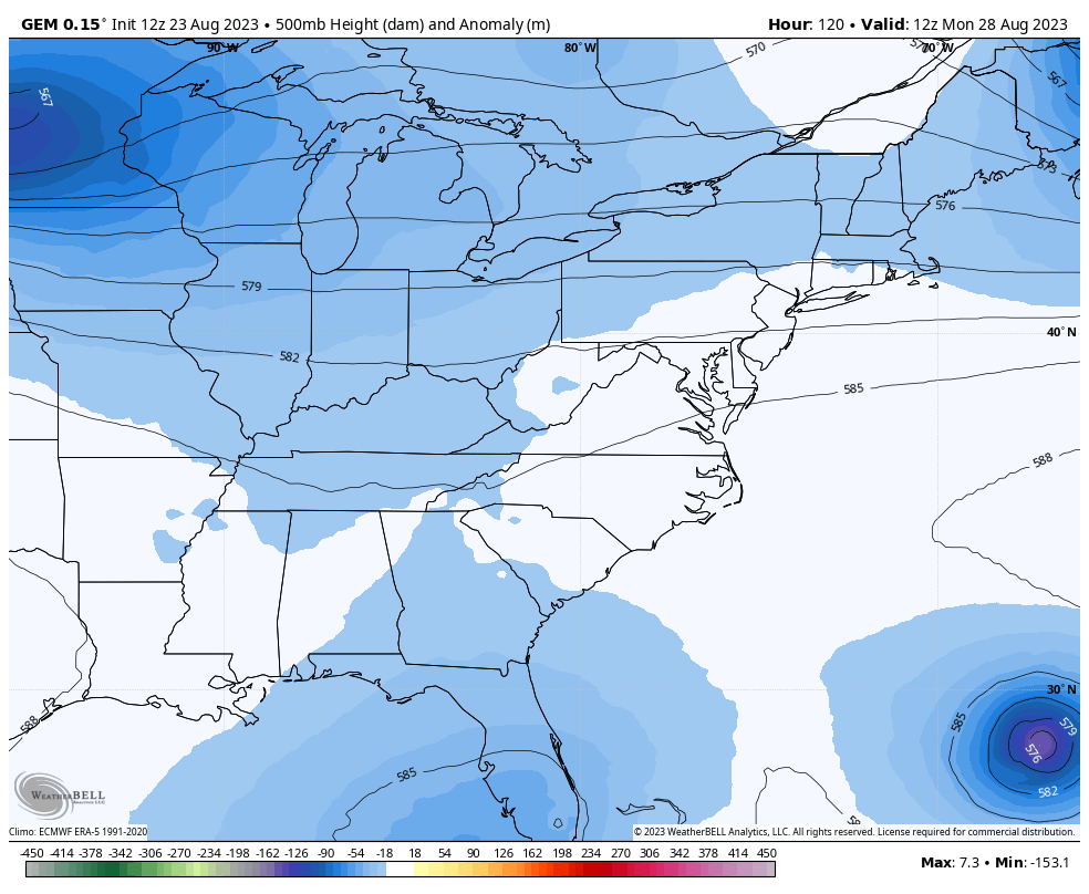
The Canadian shows this merging with the trough in the northeastern US…

While likely overdone, this scenario at 500mb is pretty cool to see…
The GFS isn’t that deep with it, but it’s likely too progressive with the trough…
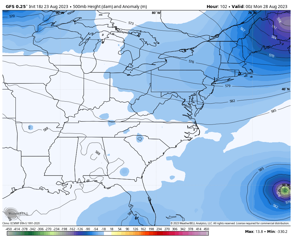
The GFS also isn’t biting on the tropical system in the eastern Gulf…

Cool temps are likely next week with lows that can dive deep into the 50s for several mornings.
I leave you with your storm tracking tools for the day…

Current watches

Possible Watch Areas

Make it a great day and take care.

Not sure. I wonder if Chris meant to say northeast to southwest movement… which is the motion it looks like these storms are moving.
Let’s hope this is the LAST of any heatwaves until spring……I dunno though, Sept can be really iffy in that department.
September 2002 had a high or two in the 90s and late September 2019 had highs pushing near 100. You just never know.
Wow, It’s 71 degrees and has been raining for a while in Greenup Co. Almost a tenth of an inch, not much but will take it.
Dreading this afternoon, It’ll be like a sauna If it clears out. I hope the rain and clouds stick around and we miss the heat here. Fingers crossed!
At my PWS just south of Bowling Green the current temperature is 92,5°F, the dewpoint is 81.7°F, and the heat index is 114.7°F.
I am soooo ready for Fall…
Me too Joe wild heat index. I hope all our air conditioning holds up.
Looks like temperatures are going to exceed 100 degrees today at Chicago’s O’Hare Airport! At 1 PM CDT it was 98 degrees there with a dew point of 77 and a heat index of 113.
There’s only a 30 percent chance of storms developing towards evening in the Chicago Metro Area, but if they do develop they could become severe.
Mike, just saw that the NWS Chicago/O’hare confirmed that you hit 100°F just before 3:00 pm CDT.
At 2:00 pm CDT my PWS just south of Bowling Green reported a temperature of 99°F, a dewpoint of 80.5°F, and a stifling heat index of 121.5°F.
It’s nuts!
Right Joe. That tied the record for the date set back in 1947. Also, it’s the first time that O’Hare has reached 100 degrees since July of 2012, and the first time in the month of August since 1991!
The maximum Heat Index at O’Hare reached 120 degrees, the highest ever recorded there, beating the 118 degree Heat Index set back in July of 1995.
It’s crazy for sure!
Severe thunderstorms have developed in SE Wisconsin this early evening, but those are moving out over Lake Michigan and will likely miss the Chicago area. A Severe Thunderstorm Watch has been issued for far Northern IL for the counties bordering Wisconsin.
Looks like SE Wisconsin and much of Lower Michigan will see the worst of the severe weather tonight.