Good Monday, folks. We are in the closing days of August and we have a pretty busy setup across the eastern half of the country. The end result of this pattern is for heavy rain to threaten southeastern Kentucky tonight and Tuesday with a blast of late September air for everyone this week.
Meanwhile, Idalia is becoming a hurricane and will hit Florida late Tuesday night and Wednesday.
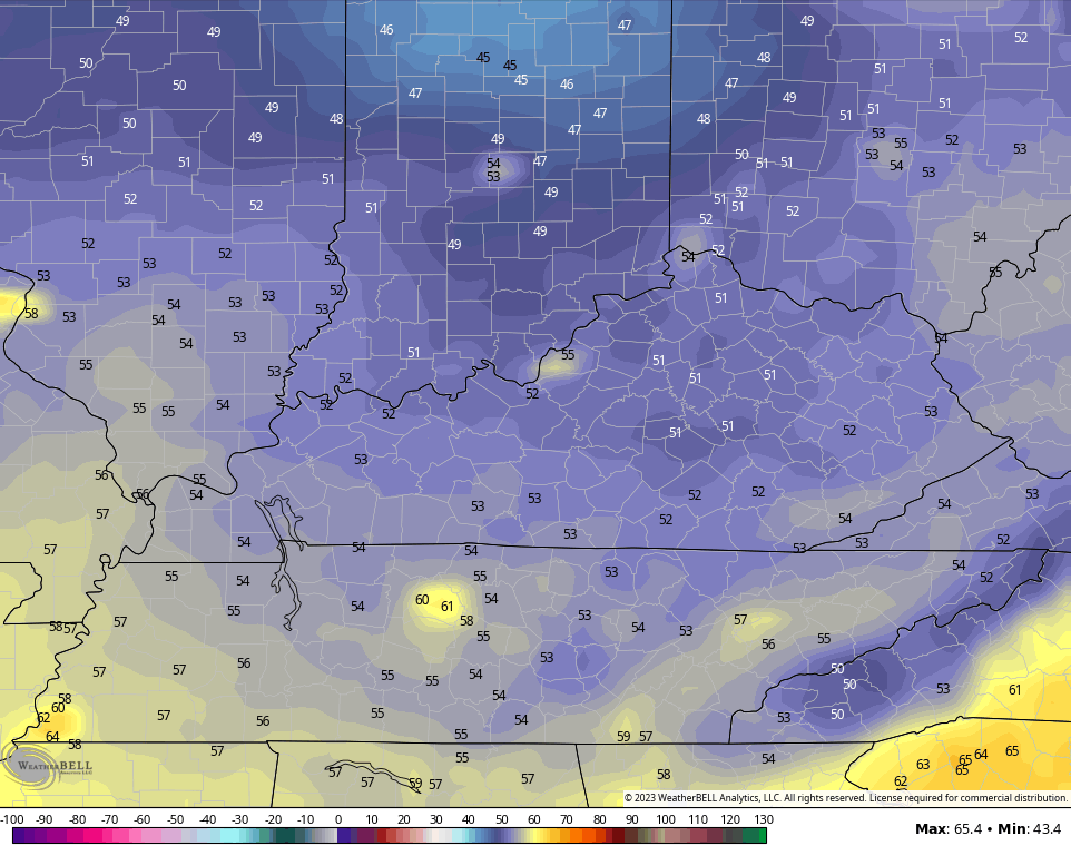
Let’s begin with today and roll forward. Highs today are mainly 80-85 in most areas with a mix of sun and clouds. Scattered showers and a rumble of thunder may show up across the south and east. This is the area we have to be on guard for a sneaky band of showers and storms to show up tonight and Tuesday. It’s this area where a corridor or torrential rains may show up…
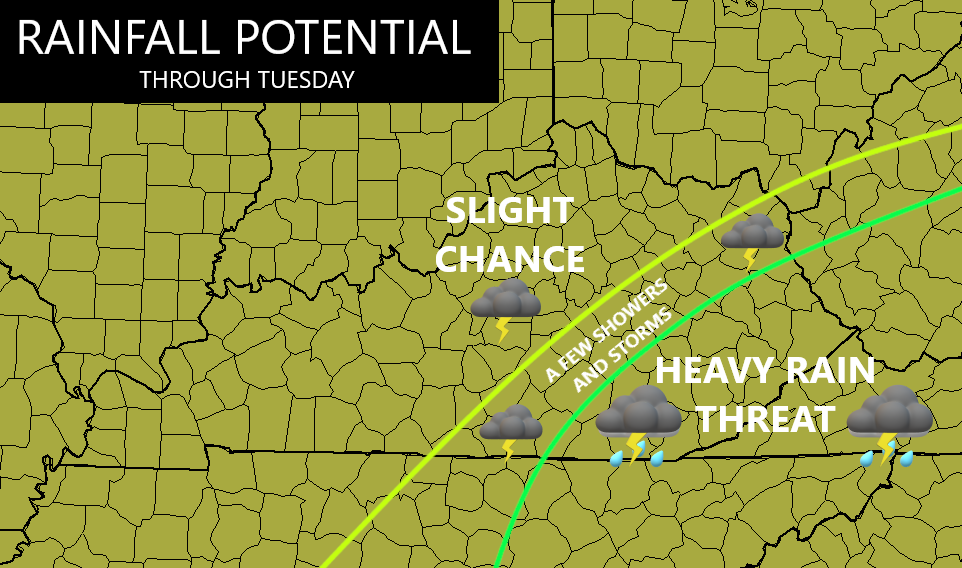
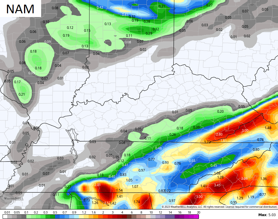
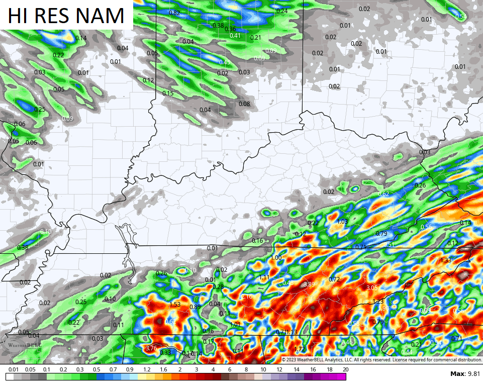
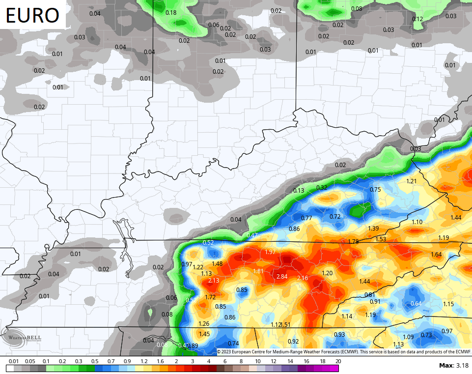
The models are seeing this potential, but disagree on the placement and overall totals…
![]()
![]()
This is being pushed by a deep trough sweeping into the eastern half of the country through Thursday. This trough helps take Idalia east through the Carolinas and into the Atlantic. This is a very busy look with Franklin, Idalia and our deep trough…

Some REALLY pleasant air sweeps in with this for the Wednesday and Thursday, the final two days of August. Lows by Thursday morning will be close to 50 degrees…
Temps are set to turn seasonably toasty for Labor Day Weekend and that deserves a big Ol BLAH! 🤬 But, at least, it’s dry! 😎
Idalia is likely to become a hurricane later today or tonight as it churns into the eastern Gulf of Mexico…

This is likely heading toward a late Tuesday night landfall near the big bend of Florida and I believe it can get to Cat 3 or greater status. Here’s the current information, track and watches/warnings from the National Hurricane Center…
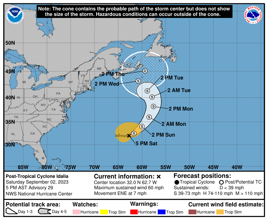
Again, those forecasts generally mirror the greatest concentration of the various hurricane models…

The GFS Ensembles are also clustered very close to the Hurricane Models…

The HWRF is a really good hurricane model and it shows Idalia intensifying as it’s coming ashore late Tuesday night…

Storms that are strengthening as they come ashore are especially dangerous.
This should create a healthy storm surge that’s going to become a big issue…
![[Image of cumulative wind history]](https://www.nhc.noaa.gov/storm_graphics/AT10/refresh/AL102023_peak_surge+png/235357_peak_surge.png)
I leave you with your scattered showers and storms tracking tools to start the week…

Have a magnificent Monday and take care.

Thanks Chris. Great detail on the impending Hurricane for the Gulf. Hope my older Sister and Brother in Law are heading North before the traffic gets heavy. I will call and remind them to get out of Florida. They went through the last one and it scared them so much that I thought they would move back to Cincinnati.
Will be glad when we are discussing the upcoming Fall and Winter. The Old Farmers Almanac predicts a Cold and Snowy Winter for our area. We shall see. I would feel more confident in that forecast if the Atlantic Multi- Decadal Oscillation went negative. That would also stop the Tropical activity now. Hoping the switch happens this Winter or sooner.
Schroeder I saw that about the almanac. I hope it’s true but as you said we shall see. Looks like I may be in for some heavy rain.
I hope it pans out too Crystal. Going through another Winter without least one major Snow would be a record for me. Since I been here 15 years I’ve only experience 2 major Snows. Both occurred in the month of February. That makes sense. February on average is our Snowiest month. Your more likely to receive the most Snow days in any Winter because of Pikeville’s location, a different climate than what Western and Central Kentucky have. Cooler by a lot due to elevation.
It’s dry here compared to the rest of the state. Most areas have had way too much rain for one season. Just hope you receive a nice pleasant rain event. We don’t want anymore floods in any part of the state.
The GFS ( Global Forecast System ) has predicted some ridiculous high temperatures again on the seven day Ventusky Weather Site. To me, this is very Sad because this weather model is the American Model which should be the best of all models in the World. The NWS says just ignore. I can’t believe what is going on in our Great Country. No wonder I keep bringing up the past.
The model had a good run this past winter.
I don’t know if it has been tinker with since the past winter.
It definitely has a temperature flaw at this moment.
I wonder if the GFS developers do make an attempt to repair it, it will only scr£w the accuracy in other climate measurements.
After a dozen days without rain, we picked up 1.25″ of welcome relief on Sunday.
That area of shear NW of Cuba is lessening, and should pose minimal weakening for Idalia. The storm will steadily strengthen right up to landfall. With slow mvmt and 90°F water temperatures off shore, Idalia could easily reach Ctg 2 or 3.
Only about 0.40 of an inch here in Maple. Kind of an on / off event. Crops are already made and maybe an early harvest if drying rates are adequate. Where I live we worry about Forest Fires if the Autumn season gets too dry.
Very well could be a Category 3 or 4 depends on how long Idalia ( strange name ) stays out in open water. Also the exact path is determined by where the high pressure ( southeast rim ) location is. The farther west the center of higher pressure the farther west landfall will be along the Gulf coast. Could make landfall somewhere in Alabama. Don’t know.
No blah from me regarding temps. 🙂
Me either until weeks end then the ridge will build back in. The heat will most likely be on next week. Hopefully, won’t be as bad as last week with dew points in the 80’s. I would rather have the heat and humidity in June and July and not in September, but only Mother Nature can choose our weather type. ( no kidding ) LOL…