Good evening, folks. I wanted to drop by for a quick update on where things stand as we roll through the rest of the weekend and into next week. Spoiler alert: I really have no big changes to my overall thoughts. 😎
Winds are cranking as the clipper passes just to our north and northeast. A few showers are exiting northeastern Kentucky…

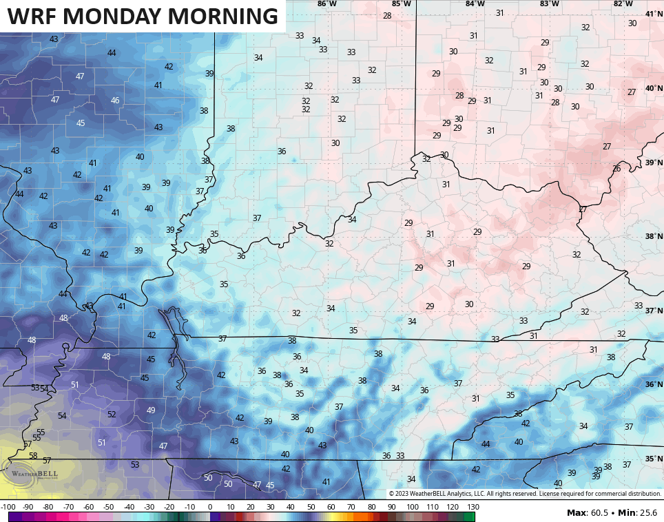
Sunday looks good with 55-60 east and mid 60s west. With dry air in place, the numbers really drop Sunday night and Monday. Most of the models are skewed warmer than reality with overnight lows and that’s really been showing up the past few months.
The WRF has actually had the best handle on lows and it shows the potential for widespread frost and a light freeze…
Mild winds kick in after this with readings hitting the 70s next week with mainly dry skies until the threat for some showers Thursday and Friday.
The pattern is going to turn much colder after this with the arrival of a cold pattern still in question. One of the reasons is Hurricane Tammy that slowly meanders around in the western Atlantic this week…

The models are trying to keep this thing hanging around a little longer. Here are the Hurricane Models…

The GFS Ensembles have a few members taking this well to the west toward the east coast with others taking this thing well out to sea…

The slower that thing is, the slower the arrival of the real cold is. But, it’s coming…
Enjoy the rest of your evening and take care.

Looking at several Mid-Atlantic wind charts, they show that steering currents at low and upper levels are moving west to east, which means that the winds needed to move Tammy towards the coast are moving in the opposite direction. So the coast is clear for the cold!