Good Saturday, everyone. A cold front is pushing into the region today, bringing scattered showers and a big temp gradient with it. This front then gets much more active Sunday and Monday with widespread rain and a winter looking setup coming in behind it.
Scattered showers are out there today and they’re streaming in from southwest to northeast. The greatest concentration is across central and western parts of the state with much less activitity in the east and southeast.
Here are your radars for the day…

Temps today fall into the 50s in the far north and west as our front sags across the Ohio River. Areas of the east and southeast will have highs deep into the 70s.
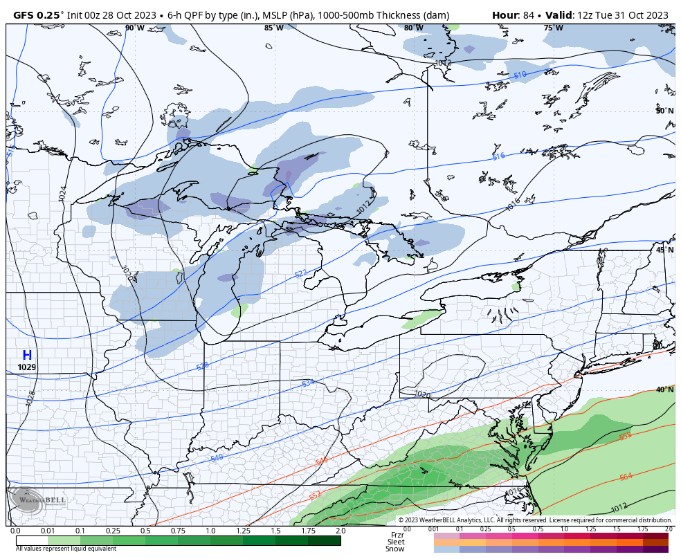
This front remains stationary into Sunday as a wave of low pressure develops and moves along it. This brings widespread rain to the region into the first half of Monday. Here’s the NAM from 8pm this evening through 2pm Monday…
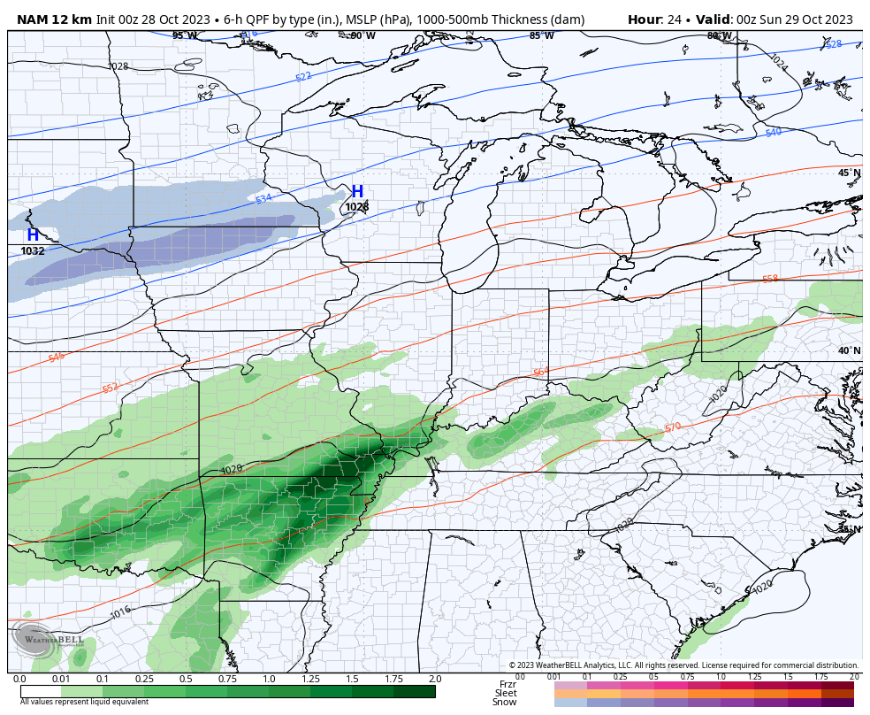
You can also see winter weather showing up on the west and northwest side of the precipitation shield with that action as close by as Illinois, Missouri and Arkansas on that run.
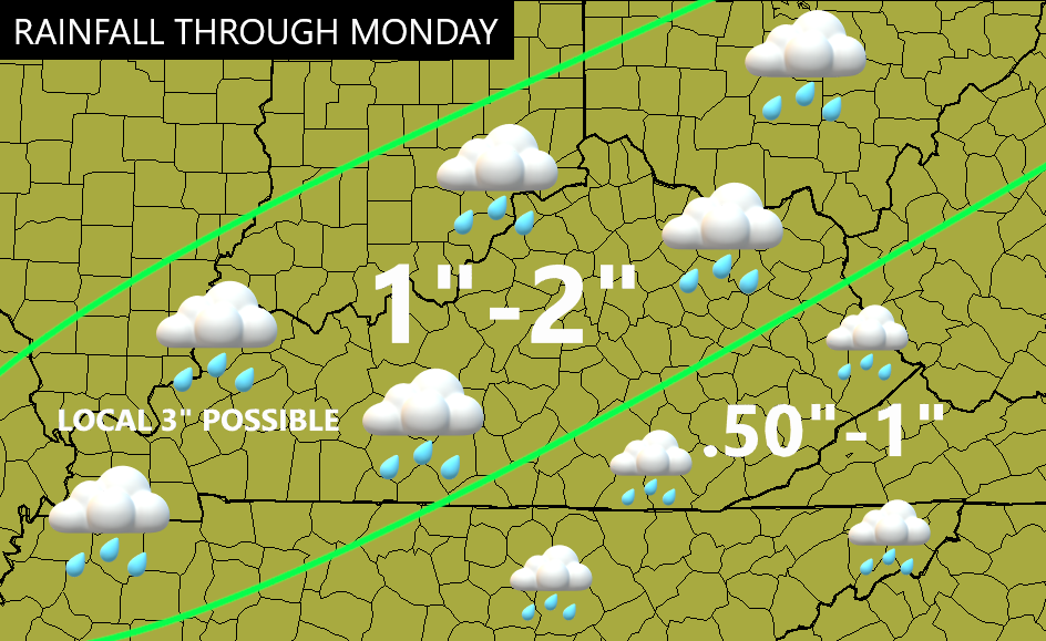
For Kentucky, this is a healthy rain event with a widespread 1″-2″ likely with some local 3″ amounts possible in the west. Here’s a look at what I’m expecting through Monday…
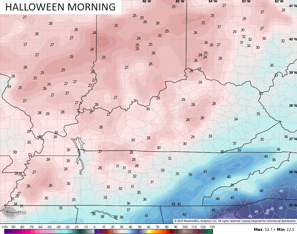
Temps crash from northwest to southeast with highs in the 40s on Monday. That sets the stage for a cold Monday night and Halloween morning with many areas dropping into the 20s…
Halloween is windy and cold with temps in the 40s as we await the arrival of another system dropping in from the northwest. Ahead of it, there’s the chance for a few showers into eastern Kentucky.
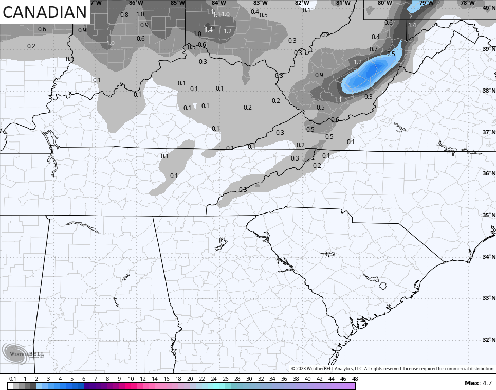
The system coming in from the northwest has even colder air coming in behind it Halloween night into the first few days of November. Introducing this will be the chance for the first flakes of the season to fly and the Canadian continues to lead the charge…
Here are the areas the Canadian sees getting in on the Halloween night and Wednesday flake action…
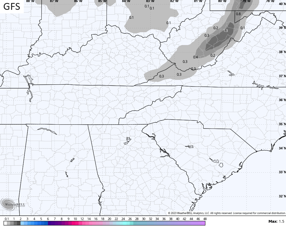
One of the MANY GFS biases is to be too progressive with systems. The GFS started with this system zipping almost due east across the Great Lakes with very little precip anywhere. As we get closer, we find the GFS correcting toward what other models have been showing all along…
Notice how the coverage area of the flakes is growing a bit from earlier runs…
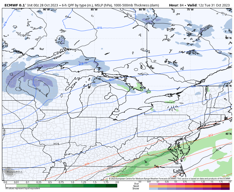
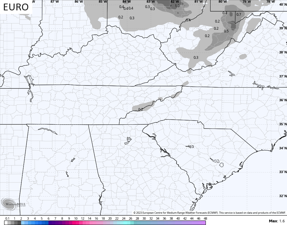
The EURO is still just north of us with the flakes…
Temps behind this are frigid with highs only in the 40s Halloween Day, but those quickly drop through the 30s during Trick or Treat times. With gusty northwest winds, wind chill temps will likely drop into the 20s for the little ones making their candy rounds…
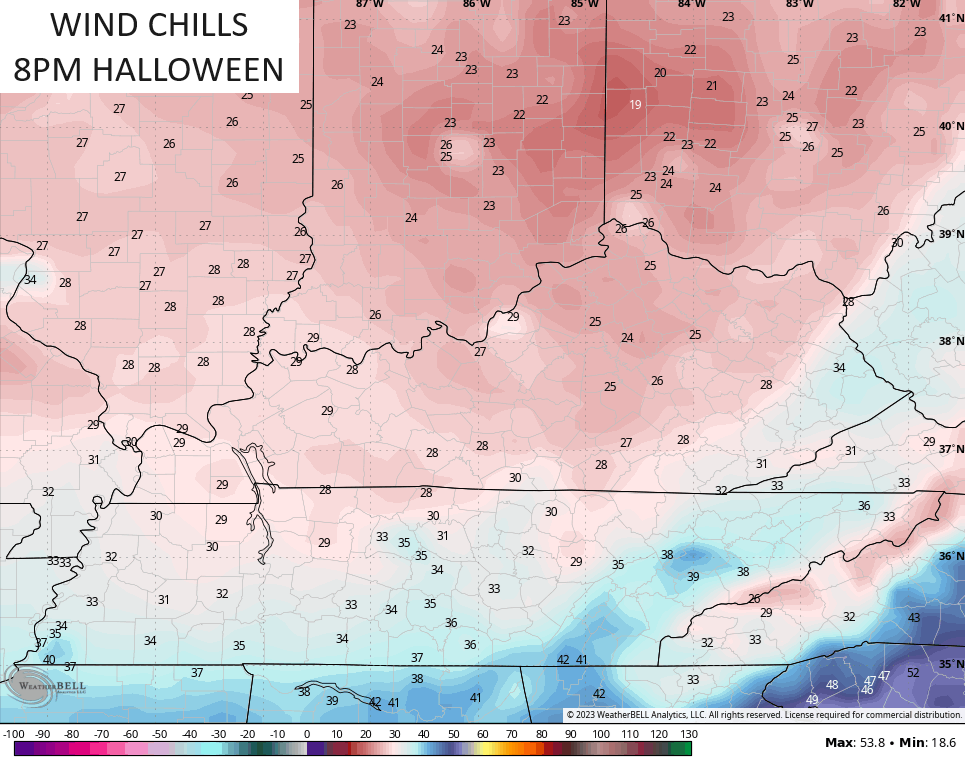
Lows by Wednesday morning are deep into the 20s with a wind chill that can reach the teens. Highs only reach 40-45 on day 1 of November with another frigid night to follow.
Temps will come up toward a more seasonable brand of November chill by late week into the following weekend before another trough likely digs in here during the second week of the month.
To get your winter juices flowing even more, check out the massive amounts of snow getting ready to blanket Colorado…
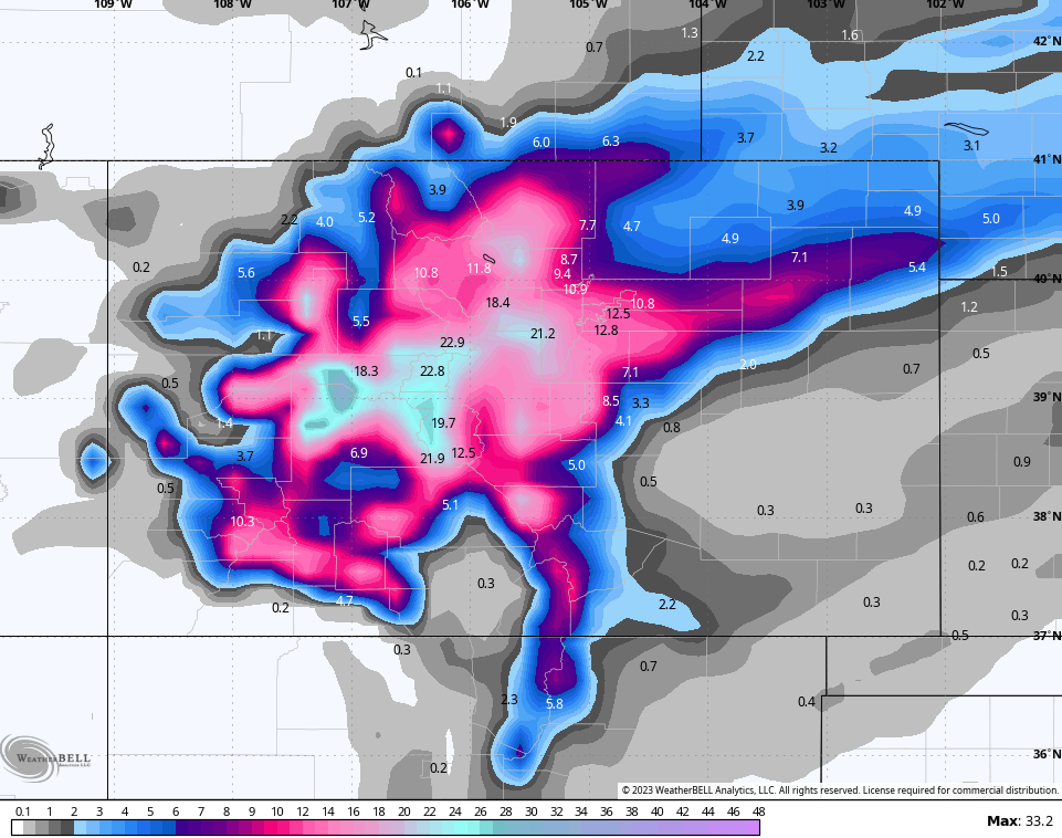
😲😲 Y’all up for a Rocky Mountain road trip? 🚙
I’ll have another update later today. Until then, make it a good one and take care.

Chris is handing out snow ensembles for trick-or-treat.
We won’t get any snow.
Thanks Chris. Halloween is suppose to be cold, scary and fun for all the Kids both big and little. In fact my Family and I will be making Jack O Lanterns for my two year old Great Niece today.
We haven’t even had our first Frost. Tuesday or Wednesday morning, they the NWS is predicting a Hard Freeze in my area ending the growing season. Hoping we receive the soaking rains that are predicted. The last several rains have miss us to the North and West due to the strong Southeast Ridge. I’m doubtful on the back side Snow flurries. Maybe in Eastern Kentucky it might happen in the Mountains.
Looks like the East based El Nino will be good for skiers in the Rockies early this Winter. It the the same as last year with the third La Nina. Which makes me think that this Winter will be just a repeat of last Winter. NOAA has finally told me that the PDO must be in the positive phase to have an El Nino impact on our area of the country. Maybe it will later this Winter. We had an impact from El Nino in 2014 to 2015 and we were Snowbound for a week in February 2015.
Another storm that was a total bust (in a good way if you love snow) was Feb 1998. I had only lived here a couple of years at that point. Nothing but a dusting they said…on the radio at midnight as I was driving home around midnight and it was POURING snow… I remember thinking this must just be a heavy brief snow shower or something. It absolutely snowed like crazy all night and most of the next day… and there was wind… It really reminded me of the superstorm 1993 in western NC
I think we ended up with 17 or 18 inches in Lexington and I think Louisville had 22…..same with Cincy… I think anything Dayton or north missed it completely…
After the main storm stopped…I remember it slowed lightly on and off for a few days… It stayed overcast… snow was very slow to melt…
My friend moved up here from NC to work… Her hometown was Portland Maine. She got a house in Harrodsburg…on a farm… She was like a house sitter for the winter for them…She was absolutely disgusted with that storm…LOL She was stuck there for a week.
It’s so funny you can’t find hardly any pictures of that storm online at all.
Mark, if you google “February 1998 Kentucky snowstorm” several informative links regarding that snowstorm (which started on Feb. 3rd) show up.
According to the WDFB Blog, an interesting aspect of that storm was that the moisture source for it was the Atlantic Ocean, not the Gulf of Mexico.
You’re correct, Lexington received a three-day total of 17.4 inches of snow, while Louisville received 22.4 inches, the most they’ve ever received in a three-day stretch.
Mark and Mike, here’s the pictures of that 1998 Kentucky Snowstorm :
https://www.google.com/search?sca_esv=577486022&hl=en&sxsrf=AM9HkKnSTnqBu_Mb6trNUmKGTMcMA82yCg:1698521135233&q=pictures+of+1998+snowstorm+in+elizabethtown+ky&tbm=isch&source=univ&fir=gphvz9JQJ5EZlM%252CGNUYZ6Asbc_MUM%252C_%253BFz5-fY46AMbmvM%252CIi8b0znLhkSHcM%252C_%253BsKboROzH_SFIBM%252CIi8b0znLhkSHcM%252C_%253BxbCMRYH_Ae3I5M%252CNXBfSkqTJo4HJM%252C_%253BGlAL00kw61Gy4M%252C_iCnQQq-sSfj-M%252C_%253BBhEZvr67IGOAdM%252C_FUvzQuP2IIBlM%252C_%253Bfhbw18hMk5vUFM%252C8gT72XMwUIArbM%252C_%253B84DDk_KtrGBv3M%252C8gT72XMwUIArbM%252C_%253BlI4TRdyKwXCbMM%252CmqMyzw7KuiodjM%252C_%253BZ-gMPreOOK3l9M%252Cu0jQ5EoJlSC1hM%252C_&usg=AI4_-kT-uZ6uaYOIeelIbeDtCN9JuIlz9A&sa=X&ved=2ahUKEwj__aGnvJmCAxWqkmoFHb5NAhsQ420oAHoECA0QPg&biw=1093&bih=489&dpr=1.25#imgrc=wqenCZGOWCqtCM
Just found out that 1997 – 1998 was a very strong El Nino year. And I’m sure the PDO was strongly positive in February 1998 resulting in the Snowstorm.
We just saw the PDO rise from -3 to near neutral yesterday in a span of a few weeks. That rarely happens!