Good Sunday, folks. Mild winds continue to take center stage and that will continue to be the case for the next few days as thermometers rise even more. This is ahead of another big system set to impact our weather later in the week. That brings in another surge of colder air behind it.
Before we look ahead, let’s look back at the October pattern. I’ve talked a lot about how the weather in Kentucky and surrounding areas has pretty much been stuck in place since the spring. That continued into summer and now into fall.
Look at where the trough was for October…
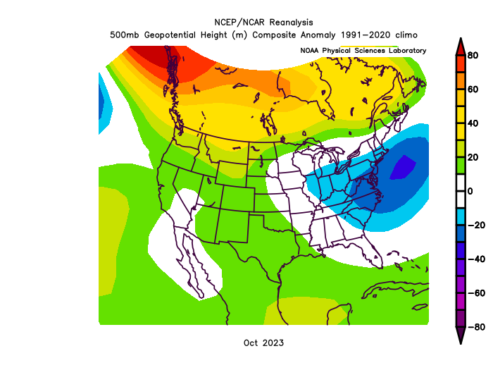
That was from the Ohio Valley to the Mid-Atlantic states. That’s essentially where it’s been for months now. This is the for the 4-month span that goes from June through September…
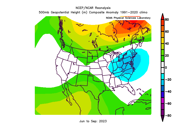
All the higher heights have been across Canada with that persistent trough in our region. There’s something to be said about persistence forecasting and until this pattern switches up, why would we want to ride anything else?
Temps out there today range from the upper 50s to middle 60s across the state. We will have a mix of sun and clouds with just the chance for a shower around early today.
Monday and Tuesday temps warm into the 65-70 degree range for many with a few spots west and south going above and beyond 70. The slight chance for a shower will be with us on Election Day, especially in the north.
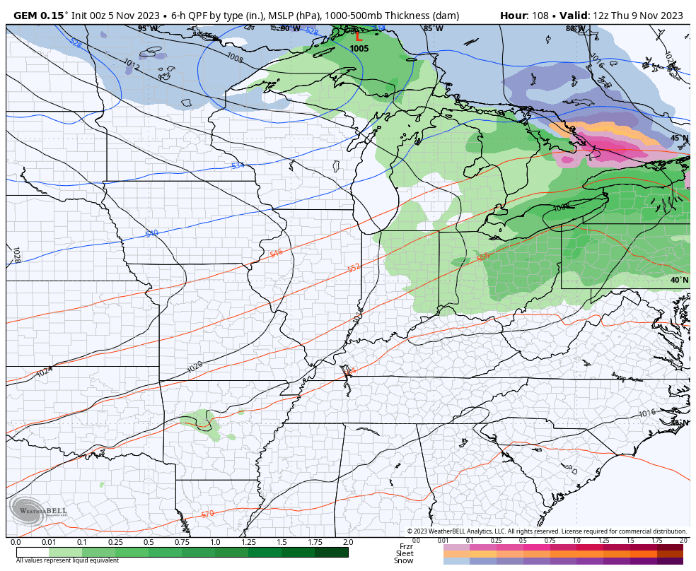
Mild temps continue into Wednesday with 70 degrees likely and the chance for a late day shower or storm. Our much ballyhooed cold front arrives Thursday with low pressure moving along it, bringing widespread rain with colder air surging in behind it.
The Canadian isn’t too far from having some flakes on the northwestern side of this system…
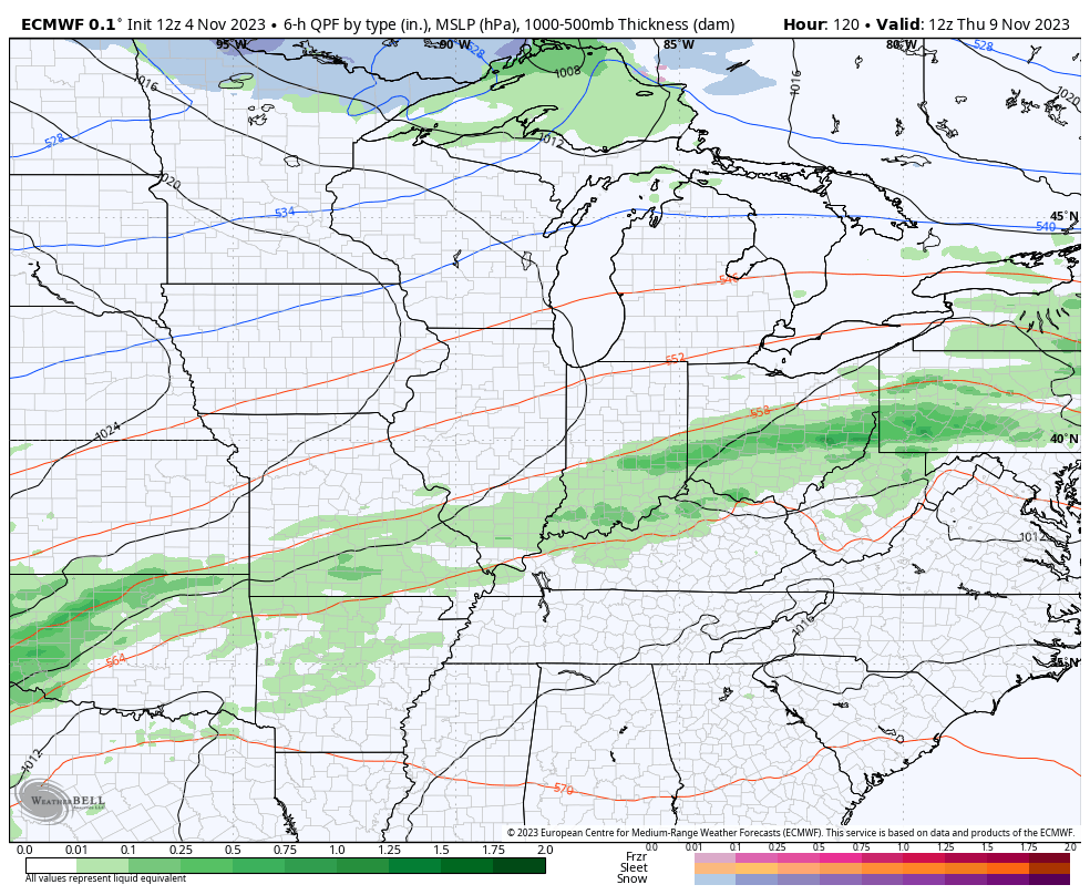
The EURO has a similar idea, but isn’t as close to the flakes as the Canadian…
 That cold air takes us into next weekend but will be followed by a week of mild air surging in for the middle of the month.
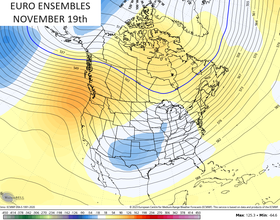
I’m continuing to watch Thanksgiving week for our next round of sustained cold and the potential for some winter. The extended models have been hinting at this for a while and the Ensembles are just now getting into the start of Thanksgiving week.
The EURO Ensembles on Sunday, November 19th shows the developing trough as a big ridge spikes up the west coast…
I’ll see you guys later today for an update. Have a great day and take care.

Thanks Chris. In my opinion, the reason we are ” stuck ” in this persistence weather pattern is due to two important Oscillations that are never discuss the PDO and the AMO. To have an El Nino impact in our part of the World the PDO has to be in the positive phase and the AMO in the negative phase. Last time this happen was in the years 2014 to 2016. A period that produce two Cold and Snowy Winters. NOAA still has no clue as to what this coming Winter will bring.
‘
someone commented yesterday confused about LA NINA or EL NINO. Either one can be cold or snowy or warm/dry really.. NWS wrote an article about that…they said no two EL NINO’s or LA NINA’s are the same… It depends on lots of things and that’s just one of them… They did mention that the most likely outcome (if I remember correctly) is a cold snowy LAST part of winter.. Take 2014 or 2015… wasn’t that winter snowless pretty much until Feb…then we got two huge snows in Feb/Mar… I think I remember reading 1997/1998 were EL NINO….A STRONG EL NINO… and no snow at all UNTIL Feb…and we got slammed with snow…. Could this season be the same? We go through DEC and JAN with nothing and then in FEB the bottom drops out? We’ll see what happens I guess
The precipitation pattern we have been in has concerned me more than the impending Snowfall later this Winter.
Believe a neutral PDO or slightly negative would work Schroeder..Looks like it’s been on the rise lately so hopefully that continues..Looks like a up and down pattern with spikes of warm and cold..Nice looking +PNA entering t-day week..After T-day looks to warm up again entering Dec..A way off so could change..Coming off a 3rd year La Niña and with record ocean temps and a changing climate will be interesting to see what happens..
What link has the current PDO and AMO phases ? All I can find is that the PDO carries a strong negative charge since May, 2023.
As long as the PDO isn’t too strongly negative, which has risen a lot in the last week, we can make winter work with a +PNA and a -EPO for some cold and snow.
In the year 2014 the PDO really phased strongly positive which in turn triggered a very strong El Nino in the years 2015 – 16. NOAA has informed me that the PDO lags positive behind the formation of ENSO in an East based ( cold pool ) El Nino, and a positive PDO in a Central based ( warm pool ) starts before El Nino forms. For Snow Lovers you would want the Central based El Nino.
Could be wrong but believe the PDO and AMO are updated every month.. Click access data for the PDO.
https://www.ncei.noaa.gov/access/monitoring/pdo/
https://tropical.colostate.edu/archive_amo.html
Sry..View data
Thanks Wx Watcher. Very interesting grafts and articles. Interesting to see and compare each year on the PDO and the AMO values.