Good Tuesday, folks. We have a clipper rolling into the region later today into early Wednesday, and this will bring showers and a touch of winter weather to the region. A much bigger storm then rumbles through here this weekend and may bring everything from strong storms to snowflakes.
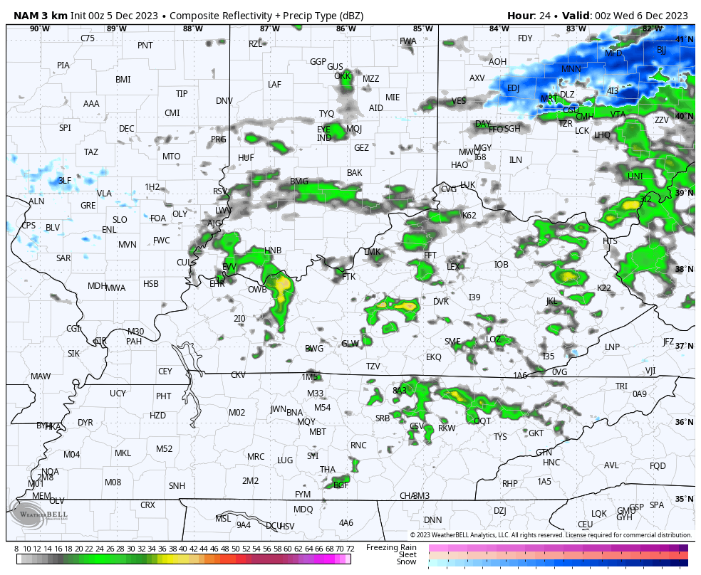
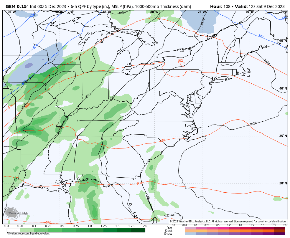
Our day is starting with some freezing fog which may impact early day travel. Otherwise, it’s another dreary day for many with a few showers this morning in the north. Scattered showers increase across central and eastern Kentucky this afternoon and evening. Here are your radars to follow today’s showers and the snow north of the Ohio River…

Colder winds kick in tonight and Wednesday as our system works to the east. This means a northwest wind flow kicks in with some flakes getting into the mix. A couple of out and out snow showers will even be possible with the greatest potential across the southeast.
Here’s the future radar from the Hi Res NAM from 7pm this evening through 10pm Wednesday…
This flow could be good enough for some VERY light accumulations across the far southeastern part of the state…
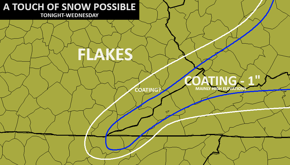
Again, that’s not much at all and it’s mainly in the high ground, but it’s a start! ❄️😁
The weekend storm system is one to watch for a number of reasons. If this storm cuts up to our west, then the threat for strong to severe thunderstorms will be possible Saturday and Saturday night with wraparound winter weather possible Sunday and Sunday night.
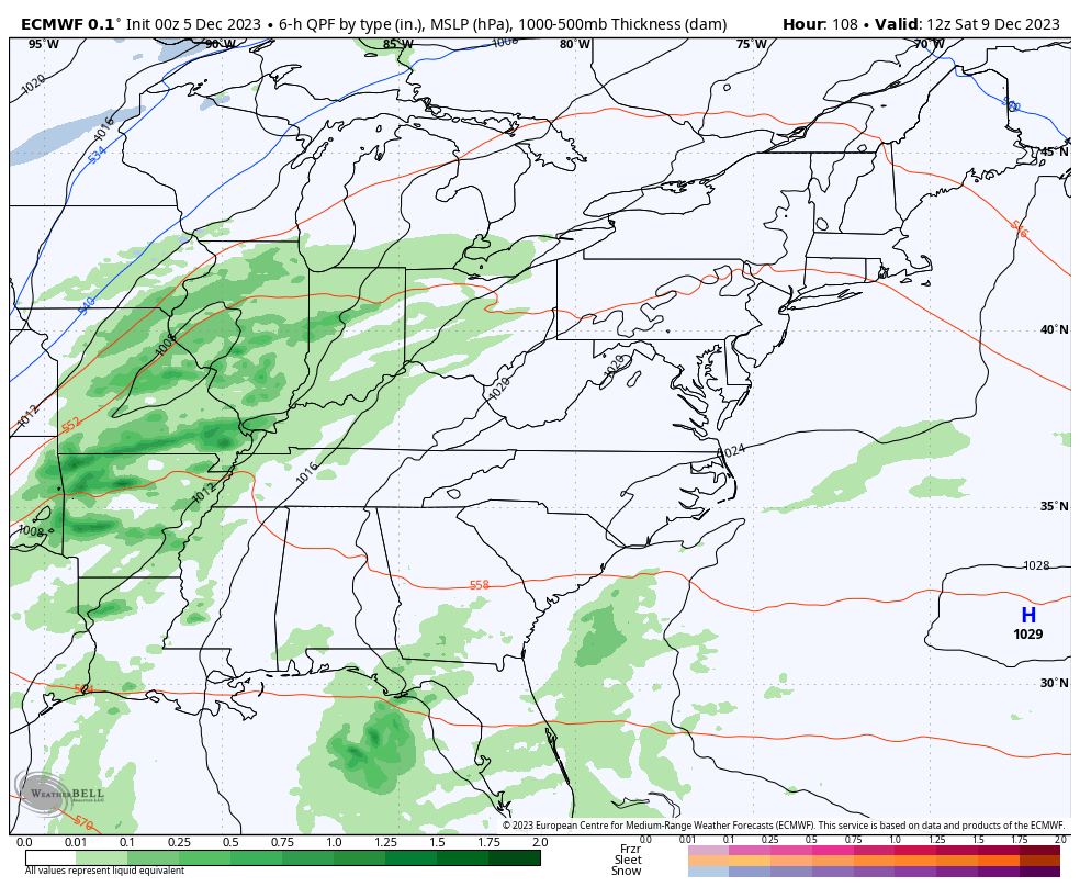
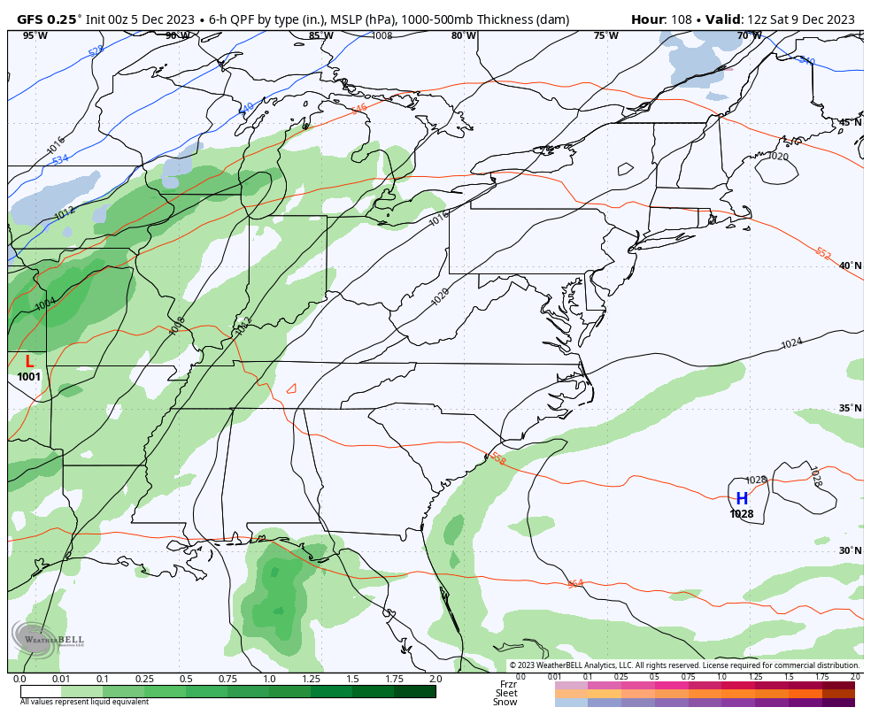
This is a track the EURO and GFS are showing…
EURO
GFS
The Canadian is farther south and cuts this storm right on top of us, giving us the threat for strong to severe storms to some winter weather…
This weekend is one to keep a close eye on as we could be talking about severe storms and high winds to snowflakes all withing a 24-hour period.
My winter forecast called for a turn toward colder than normal in late December, lasting into January and February. That signal continues to be there on the longer-range versions of the GFS and EURO.
The change toward sustained cold is likely to happen in the days leading up to Christmas. If we look at Christmas week, we find a deep trough settling into the east and, especially, southeast…
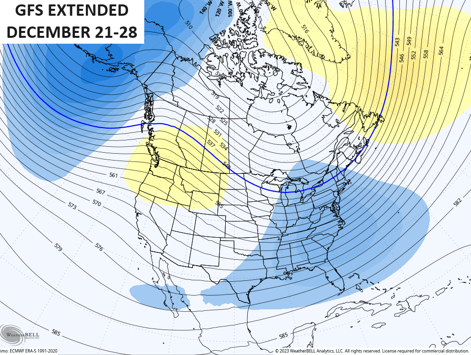
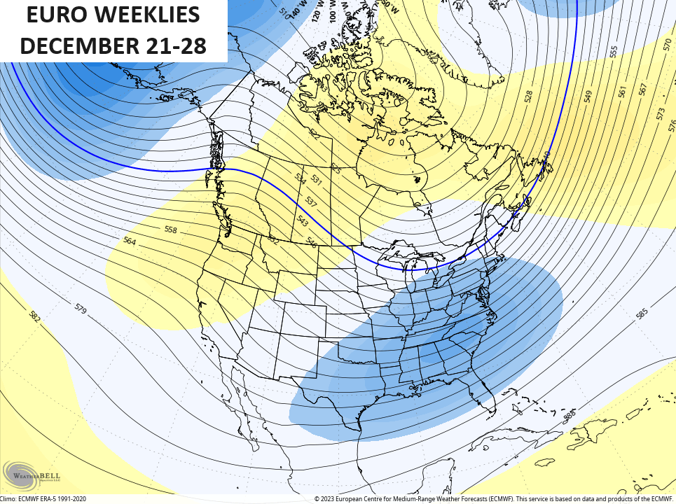
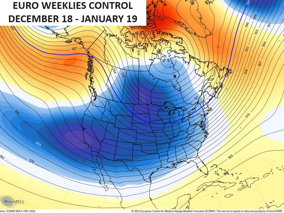
Blocking across Greenland (-NAO), ridge along the west coast(+PNA) combine with an Aleutian low to deliver an increasingly cold air mass during this time. That same setup shows up on the EURO Weeklies through the middle of January. This is a 30 day average from mid-December to mid-January…
That’s the 30 day average of 51 different members that make up the EURO Ensembles, so that’s pretty impressive.
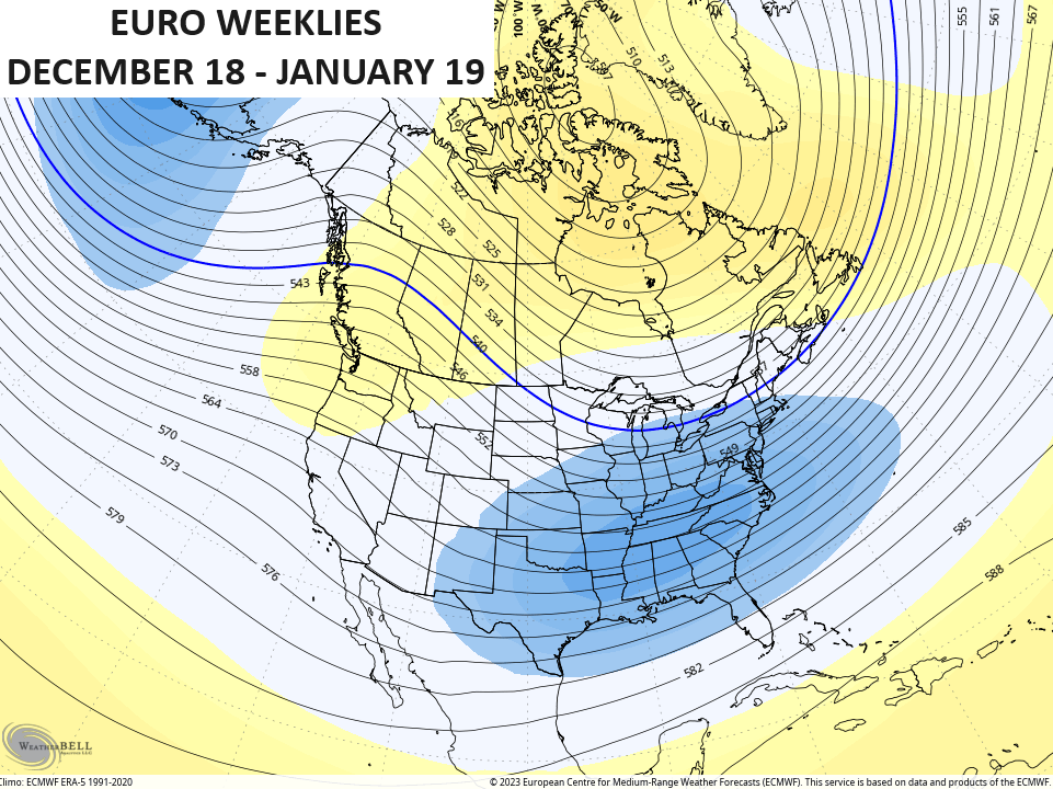
If we look at the single run of the EURO Weeklies, we find a much more widespread trough engulfing the country during that same 30 day window…
That could make for a lot of fun and games!
I’ll have another update later today. Have a terrific Tuesday and take care.

We’ll see where it’s at in two weeks. 🙂
Thanks Chris. Hoping that severe weather doesn’t occur anywhere this weekend, and we receive the steady, soaking Rains that we really need.
That’s quite a dramatic change in temperatures across the Country the various ” weather models ” are indicating, but will there be El Nino phased Storms to produce noticeable, accumulating Snows to Kentucky ?
Could there be a series of Alberta Clipper systems to our North followed by Cold, Dry air, with just a few Snow Flurries this Winter ?
Will the Winter turn out Mild and Dry or Wet ?
Questions that time can only answer.
Honestly, I’ve been reading all about how cold December would be since you’ve been hitting the winter alarm bells before Thanksgiving. It’s been warm, a little damp, but you keep pumping ‘flakes’ but that’s only for a few counties on the EXTREME eastern ky border. I think you’ve overplayed your cold cold cold hand for a few weeks now. Of coarse January and February are cold, but so is March & April. I really think you should go back to the drawing board with your forecasts. You pumped this cold weather weeks ago and it only transpired for maybe 5-days, since then it’s been so mild you’ve missed the target. It hasn’t even been close.
For weeks Chris’s forecast has been calling for below normal temperatures in November, mild temperatures during the first half of December, and a significant drop to close out the year. Sounds pretty accurate to me. As for snow, the forecast has mentioned a few flakes, mostly in the east, which is normal for this time of year.
I read every single day, and have for many years. Chris is very accurate and provides a lot of insight about what is going on with the forecasting. Never get caught up too much on 1 single word he says as most of the time it comes with conditions. He has stated for several weeks now that the temps would be colder than normal in November (they were), with a Mild early to mid December (it has been), and then a change to colder than normal late portion of December (jury is still out, but the signals are pointing at it). To me everything has been spot on so far. Watch his winter weather forecast on WKYT, it was all laid out really nicely there.
This is a demonstrably bad and false take.
Hey JoeDfromBG – this is from November 18th post.
‘Make no mistake, this is a winter setup being unleashed with multiple storm systems that take aim at the region late this month and likely into early December’.
‘Early December?’ ……….My analysis is correct.
Believe me, this is my go-to weather forecast, but the calls for cold for the past few weeks have been overstated at best.
*winter setup* You would have to admit is somewhat ambiguous.
You right, ‘winter setup’ means mid 50’s and mild temps. You win.
In my opinion they are making long ranged weather outlooks difficult. Here’s weather in a nutshell : If you have an El Nino in the positive phase expect a long, cold and Snowy Winter. If El Nino is present in the negative phase expect a mild Winter. Unfortunately, so far this year El Nino is in the negative phase. That’s my take on the weather. Just except what the Good Lord gives us in the way of weather and be happy for what you have.
The doom and gloom of really cold weather that was forecast weeks ago has not appeared. Remember the oscillation map that was presented? I’m happy with the forecast on this site and no one can accurately predict the weather, so all I’m saying that for past two weeks, the forecast has been less than accurate……ESPECIALLY with all the COLD temps that were forecasted for December.
Now if the other guys want to jump on board and crucify someone just for pointing out the inaccuracies, then so be it, but be prepared for the blowback.
Keep on digging your hole, liar.
IMO, the rebuttals have been tamed.
Nobody has made it personal.
Everybody has their own interpretation about the future forecast.
All Chris can do is show what the models are projecting 7-10 days out.
I am sure you know not to trust any long distance model.
As Chris says ‘the models are only one of many tools that is used in forecasting.’
I doubt anybody really cares, As was pointed out on his Winter weather forecast on you tube, It’s been spot on. Also, he always says take the models, esp long-med range with a grain of salt.
You’re reading way too much into it and not getting all of the details. Making something outta nothing…
I understand that though 100%, the one that’s calling out a Chief Meteorologist for his writing Is uncalled for unless he asks for your opinion on his OWN blog.
I used to enjoy reading the comments till all of this crap.
Best chance we’ve had at a legit winter in quite some time, thanks Chris.
Around a half-inch of slushy snow accumulation fell in the Chicago Metro Area this morning, but with temps now several degrees above freezing, it has already melted.
Unseasonably mild weather is predicted here for Thursday and Friday, with highs in the 50s, but there could be a major snowstorm for Chicago or nearby on Sunday. All three computer models are differing on who gets the heavy snow.
Sounds like someone is an angry elf, and only reads black and white. Chris has never said anything this year that was all “gloom and doom” and if you are going to hang your hat on his WWF lol jokes on you. He HIMSELF says it’s all in fun, his tradition, not to be taken as gospel.
Agree I could be wrong but I thought Chris said it wasn’t go to be a very cold December and it picked up after that into January and February. I don’t envy anyone forecasting this unusual wild weather especially so far out then a day or two or unusual weather at times but like Chris says it can be fun to look at them I think Chris just tries to give us all a little winter hope and then gives his thoughts and expertise. I believe this weather in Ky is like being in Las Vegas a crap shoot can go either way because we are always on the infamous fence.