Good Monday, folks. As hard as it is to believe, we are two weeks away from Christmas and it’s, at least, feeling the part out there today. Parts of eastern Kentucky even have a few festive flakes to top it off. While a calmer pattern is with us this week, I’m focusing on the potential for a weekend system and looking farther down the road.
Our day starts with temps in the 20s with gusty winds making it feel colder. As mentioned, areas out east may see a flake or two flying this morning with the greatest concentration across the southeast.
Temps return into the 45-50 degree range for Tuesday with partly sunny skies. Temps come down a bit Wednesday through Friday but are still not too far away from normal. Skies continue to be dry during this time.
The weekend system continues to be a mystery as we wait to see what happens with a slow-moving cutoff system diving into the Gulf of Mexico. That’s a pretty unusual setup, so it’s not surprising for the models to have issues.
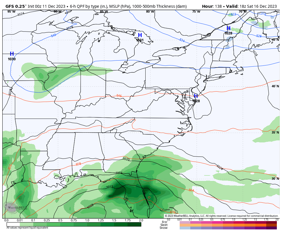
The GFS continues to bring this system out as a big east coast storm system, but the latest run keeps it too far east for us…
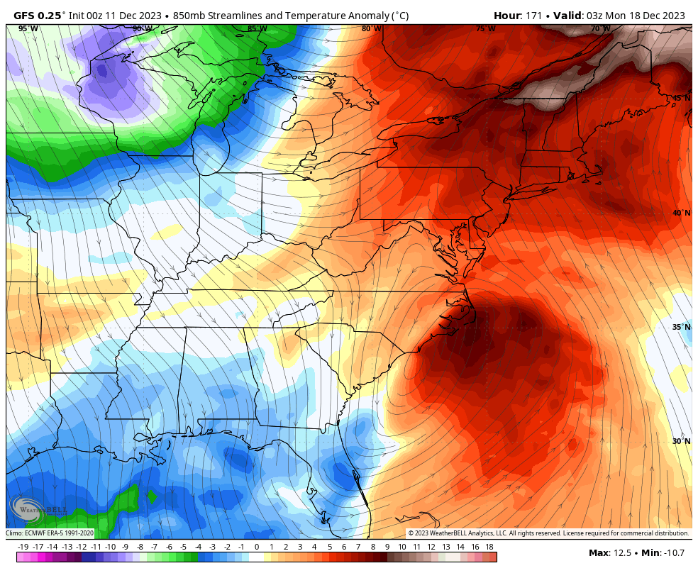
If the system behaves like that it would pull down some pretty cold air behind it into early next week. Barney could show up…
What happens if that storm system doesn’t come out of the Gulf and just hangs around off the southeastern coast for days? It blocks our pattern up pretty good and likely puts us on the boring and milder than normal side for the weekend into next week.
Using the latest run of the EURO Weeklies, we find the model still going with a trough over the southeastern part of the country…
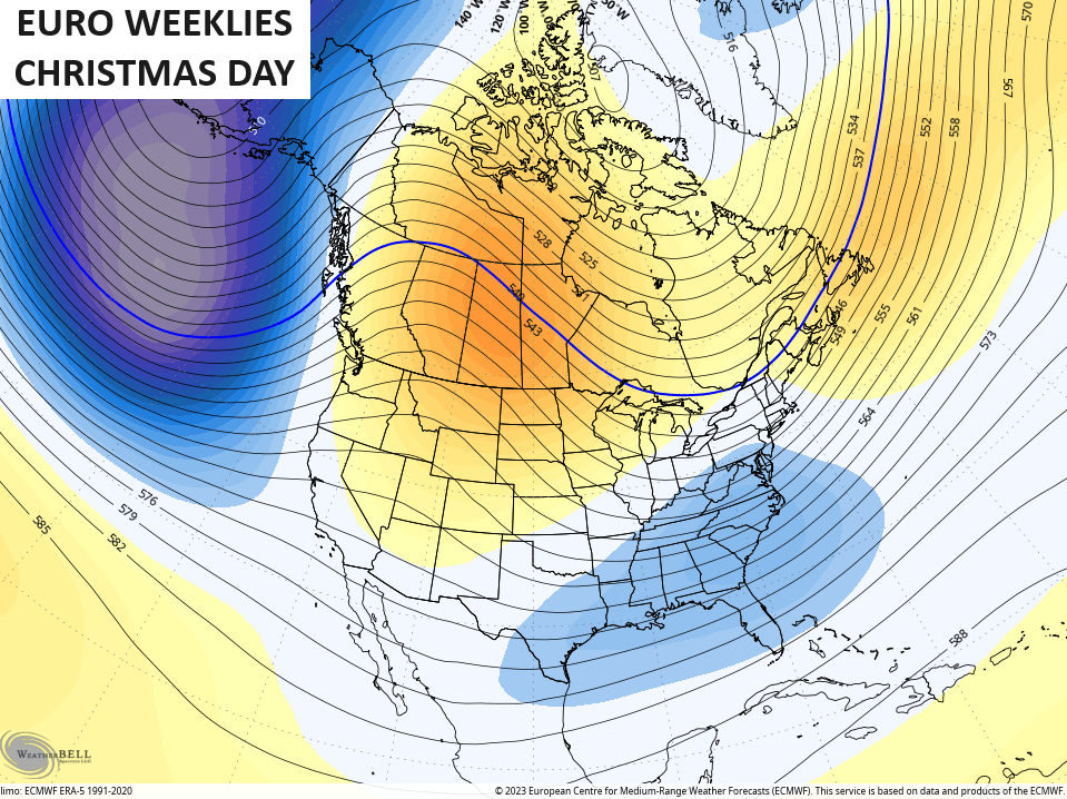
That trough develops “around” Christmas, so the exact date on that is a work in progress. Aren’t we all? 😁
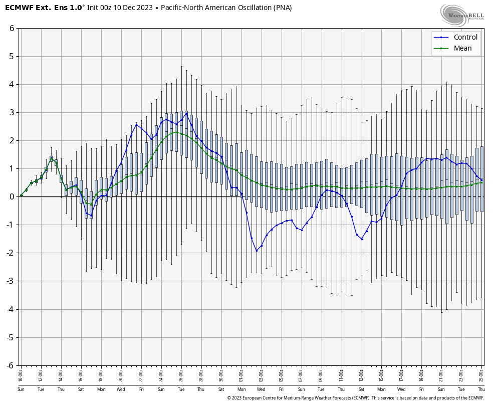
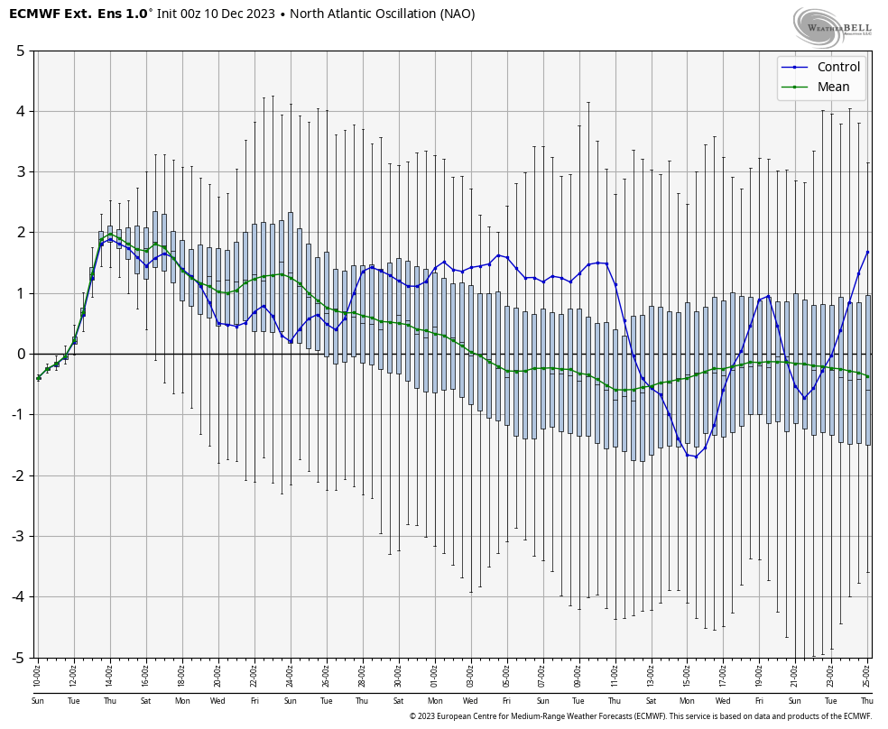
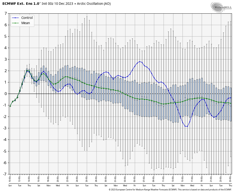
The EURO weeklies continue to show a healthy winter pattern taking shape for late December into January. This is the 30 day average of the 51 different members that make up the EURO Weeklies…
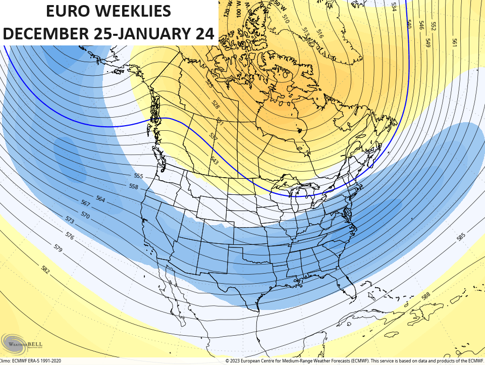
Much higher heights in Canada allow for that trough to develop underneath across the country. If we look at the various indices the model is forecasting, we can see why that’s the case.
The green line represents the average of all 51 members while the blue line is the control run.
The PNA is forecast to spike positive and it stays there on the mean…
The NAO trends negative in time…
So does the AO…
And finally, we find the EPO going negative…
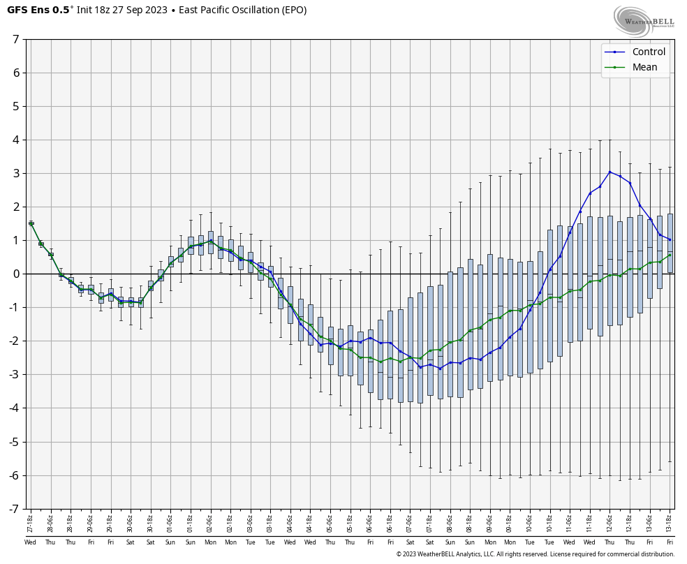
Given all of those signals, one can see why the EURO Weeklies are so gung-ho with that trough developing across much of the country from late this month into January.
I’ll have another update later today, so check back. Have a magnificent Monday and take care.

Thanks Chris for the update. I know that everyone wants a major or minor Snowstorm at this time of the year, and so far this El Nino has been a disappointment in producing such. It looks now that we may be in a drier more Pacific air pattern this Winter rather than Arctic. Being as dry as it is I would rather have the former.
Things will turn around EVENTUALLY…. we can only be in a pattern for so long. Sometimes it seems like the same pattern can last forever but when it flips it really flips.
Bingo!
If we just had a shift in the Pacific Decadal Oscillation from very negative to very positive last Spring, our weather pattern really would have changed with this El Nino in place. Phased storms moving east out of the Southern Rockies through the Southern States would have really increase our chances for much needed widespread Rains and Snows. Instead we will have to be content with occasional Severe Weather with Tornadoes, and a few scattered showers, plus a lot of dry times.
The Teleconnections : PNA, EPO, AO and NAO will only hold their charge ( positive or negative ) if the Pacific Decadal Oscillation is in a very positive phase. This may change maybe in the year 2030. Last time the PDO was in the very positive phase was in 2014 to 2015. These years there wasn’t any drought and we had a lot of periods of Cold and Snowstorms. I was able then, so I built a Snowman and took a picture and now I hang that picture up every Christmas.
As long as no big ice and/or funky winds with crazy cold, I’m good for whatever. The models are getting more and more dubious, for whatever reason. CB must have lots of fun with them, even more now.
We very rarely get a snowstorm in December anyways, looking forward to see what January will bring. But for the time being lets enjoy the rest of the month of December regardless. Have a bless day!!
In my life I’ve seen plenty of Snows in December, but not here in South Central Kentucky. I’ve also seen some very warm Decembers. For instance December 1965 was very mild. Not too confident with the Snows or any decent Rains this Winter. Unless some MAJOR changes occur in our Atmosphere.
I-75 east watch out.
For the rest of us mainly dry & below normal temperatures.
This is my unscientific forecast for the winter.
I have not seen scarcely any change in the storm pattern since the past summer.
If I had to place a bet in Vegas. I would bet below normal rainfall,temperatures,&snowfall.
I haven’t seen JOE D. from Bowling Green on Blog since Saturday. Hope he and is wife are OK after that horrible Storm on Saturday.
Hopefully for once, the MJO cooperates.
The MJO is also connected to the PDO and all other Oscillations in the Pacific. I don’t know if the MJO will phase out of the warm phase or not. It is forecast to phase to the cold phase later this month. Again don’t know.
Schroeder, you say you don’t know but you are predicting a dryer winter with Pacific air? The PDO has risen quite a bit since October, so if it stays even close to neutral this winter then it won’t hurt us. Plus having a +PNA and -EPO can drive in some really cold weather with snow chances on their own. Except for maybe last year we have gotten snow every year since 14/15 and the PDO has been negative since then until now where it’s closer to neutral that it has been in a while. I know you mention it a lot, but it’s not the only single driver out there for snow or cold. If that was the case then any meteorologist could predict what winter will be just by looking at the PDO and calling it a day.
That makes sense Jeff. Thanks for the correction. As you know, I tend to go overboard on the discussion of Meteorology. Won’t happen again. Take Care.