Good Saturday to one and all. We are starting things out with some rain and snow working across the region with some light accumulations in the north. This whole setup is kicking off a hyper-active pattern that will feature some wild weather over the next few weeks.
This morning’s snow is a hit and run job and mainly across the north with rain elsewhere. Light accumulations may show up very early today in the north. Whatever is out there will fade away very quickly, so you better enjoy any snow you get this morning. 😜
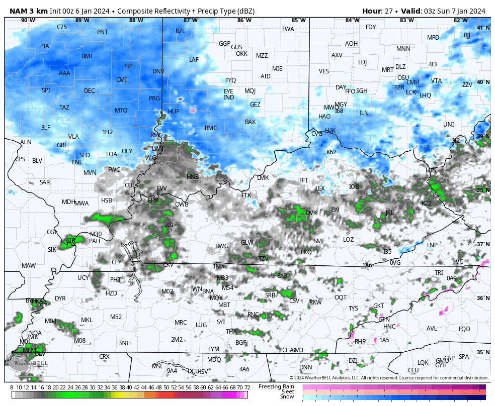
Here are your radars to follow this fast-moving rain and slushy snow maker…

After a dreary afternoon, we are dealing with another light rain and light snow maker moving in later tonight and Sunday. The future radar from the Hi Res NAM is picking up on this pretty well…
I don’t anticipate much of that sticking, but it makes for another day of some winter weather.
The next storm system is a biggie and it’s set to bring a lot of different weather to us from Monday night through Wednesday. Here’s a breakdown:
- Rain overspreads the state from the southwest Monday night. This may start as a mix or a period of snow in the north.
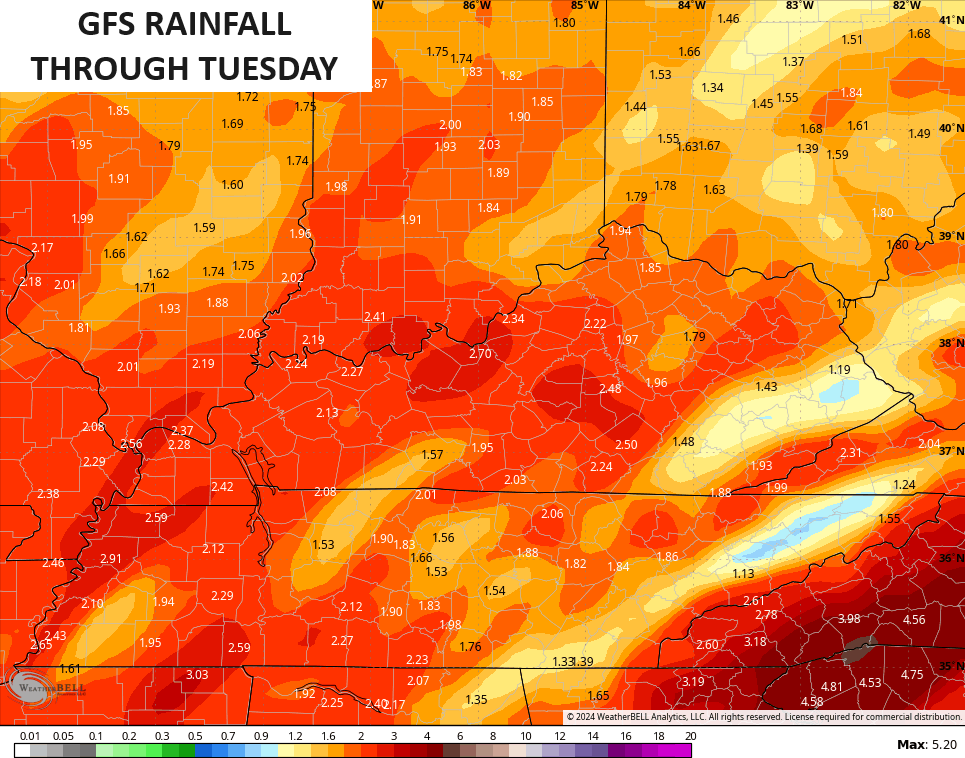
- Heavy rains of 1″-2″ will be likely Tuesday as the low works right on top of us. Some thunder is even possible.
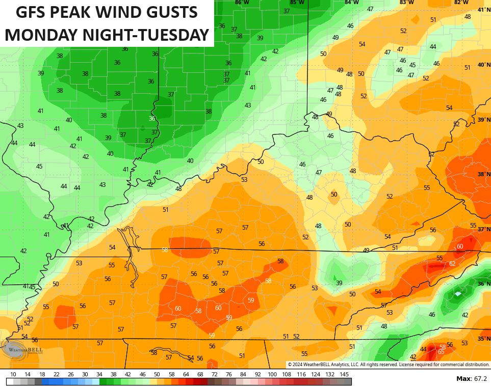
- High winds are a problem and may gust to 50mph in some spots Monday night into Tuesday.
- Cold air crashes in behind this very quickly with a transition to snow from west to east Tuesday evening and Tuesday night.
- Periods of snow continue into Wednesday with accumulations likely. This may be our first snow day for some with what may be a general 1″-3″ snow for many.
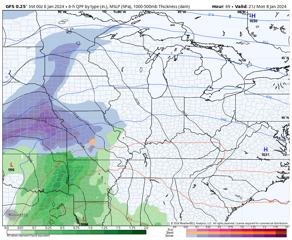
Here’s the GFS with this storm…
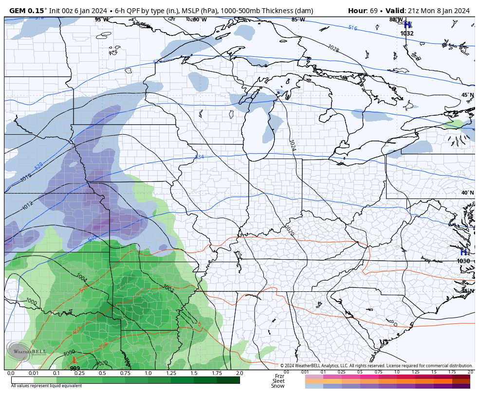
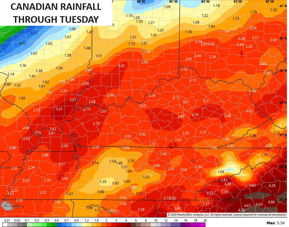
The Canadian has more of a front end snow signal in the north and has a farther east tracking system…
Winds are a major concern with gusts of 50mph possible. The GFS even has gusts pushing 60mph…
A lot of rain will fall over the next several days. The models are spitting out some healthy numbers…
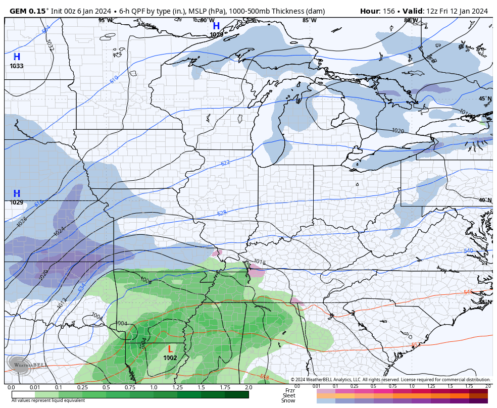
Another big time storm system is likely to follow that up by the end of the week. Once again, it will come down to the track, but it’s likely to be farther south and east from the above storm. Can we get it far enough south and east for a big hitting snow system? Maybe.
The Canadian thinks so…
The models will change a lot with the tracks, but the cold pushing more and more should mean these storm tracks also push more and more to the east and south.
Arctic cold is set to engulf much of the country. The 51 member EURO Ensembles average is crazy cold…
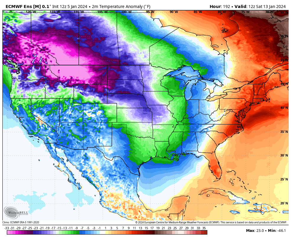
The control run is even crazier with the below normal anomalies…
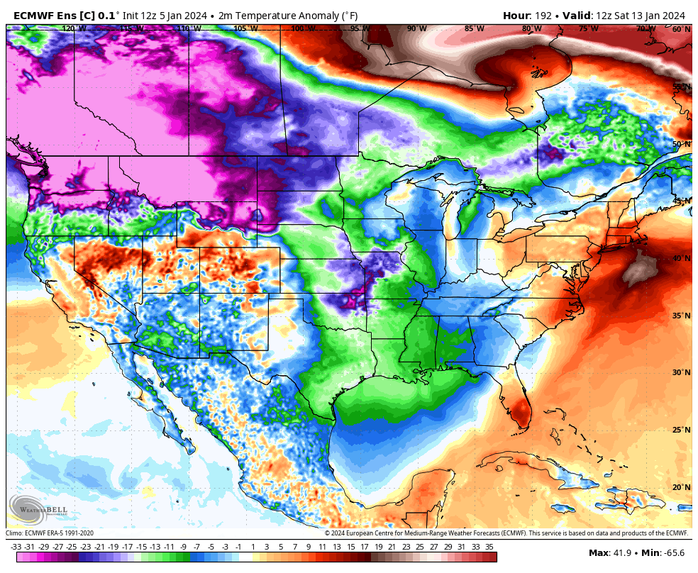
The overall pattern I see setting up has a chance to be on par with the likes of February 2021 and February-March 2015. Will it deliver the sustained winter those years did? That remains to be seen, but the next 6 weeks are loaded with potential.
Updates come your way later today. Make it a good one and take care.

Thanks for the Update and the Breakdown on what may happen Chris. A great Soaking Cold Rain early this Morning, so this may be a Start to Breaking the Severe Drought in my area. Don’t know. The next Storm may take a Track farther to the West, which would put my area in the Dry Slot. Don’t know. May get more Wind than Rain. Not expecting any Accumulating Snow on the backside of this Storm.
I Hope and Pray that the Arctic Air stays where it belongs. All that brings is Frigid, Dry Air for about a couple of days and on the Return Flow the possibility of an Ice Storm. Kentucky is noted for Devastating Ice Storms. Remember 2009 ?
Enjoy your Saturday !
Sadly I would not bet against ice being our big frozen event, rather than snow. Even less than a day out the models can’t get southern fed snow correct for the area, but they appear to do a spiffy job forecasting ice, days in advance.
It Won’t be like the Late Winter we had in 2015. The El Nino then had a PDO that was way Positive. This El Nino still has a Negative PDO. A very Strange Pattern, that I have Not seen before.
A bust for snow lovers in Northern Kentucky for sure. 🙁
Was thinking we had nowhere to go but up from snow totals last winter, but not so sure now. I’d bet money we’re more likely to get big ice more than big snow. The good news is I’m a terrible at betting!
The Chicago area received its first shovelable snowfall in almost a year this morning! A general 2-to-3 inches of snow fell throughout the area. It was a heavy, wet snow that compacted down to around an inch when I shoveled my driveway. Very picturesque, with the snow sticking to everything.
Regarding the major winter storm predicted for Monday night through Tuesday night here, the fact that temperatures may be a degree or two above freezing on Tuesday could cut down on the snow totals significantly. It’s going to be a close call, they’re not sure yet.
Looks like you guys in Kentucky will finally get that heavy, soaking rain on Tuesday which so many of you need.
We got an Inch of much needed Rain, but we need a lot more before next Springs planting season. I hope we can hold on to the normal temperatures throughout the Winter. So far Snow is a No show. A lot of disappointment on the Blog.
Non-event as predicted
What a big shift South East on the GFS for Tuesday/Wednesday…Maybe we get one to go our way this time..