Good evening, folks. No changes to the big storm system that’s rolling in here tonight and Tuesday. It’s the first of 3 big systems over the next week, with each taking on more of a winter look before arctic air crashes in.
Here’s the breakdown of this current storm:
TONIGHT
- Low pressure lifts northward into the western Ohio Valley.
- Heavy rain overspreads the region.
- A wintry mix may be noted at the start in the north, but this doesn’t look like a big deal
- Winds become a MAJOR player. Gusts between 40mph and 50mph will be possible from south to north by morning.
- Some local 60mph gusts are possible across the southern half of the state.
TUESDAY
- High winds continue with gusts potentially hitting 50mph or a bit higher in some areas.
- Wind damage may show up, especially across central and eastern Kentucky where the core of the winds will be
- Heavy rain pushes through. Rainfall totals of 1″-2″ will be a good bet.
- I can’t rule out some rumbles of thunder as temps spike into the 50s for the eastern half of the state.
TUESDAY NIGHT
- The strong low passes to our north and northeast.
- Temps crash through the 30s from west to east and wind up in the upper 20s by morning.
- Periods of light snow, snow showers and snow squalls quickly develop with light accumulations showing up.
- Any snow squall can reduce visibility very quickly.
- Winds are still cranking with 30mph-40mph gusts a safe bet.
- Wind chills will be in the middle teens as we hit morning.
WEDNESDAY
- Light snow favors central and eastern Kentucky early in the day.
- Light accumulations are likely during this time, and we may have a snow day or two.
- Setups like this usually produce an inch or so of snow, depending on just how fast this moves through.
- Winds are still gusting to 30mph or a little better.
- Temps stay in the upper 20s and low 30s with much colder wind chills.
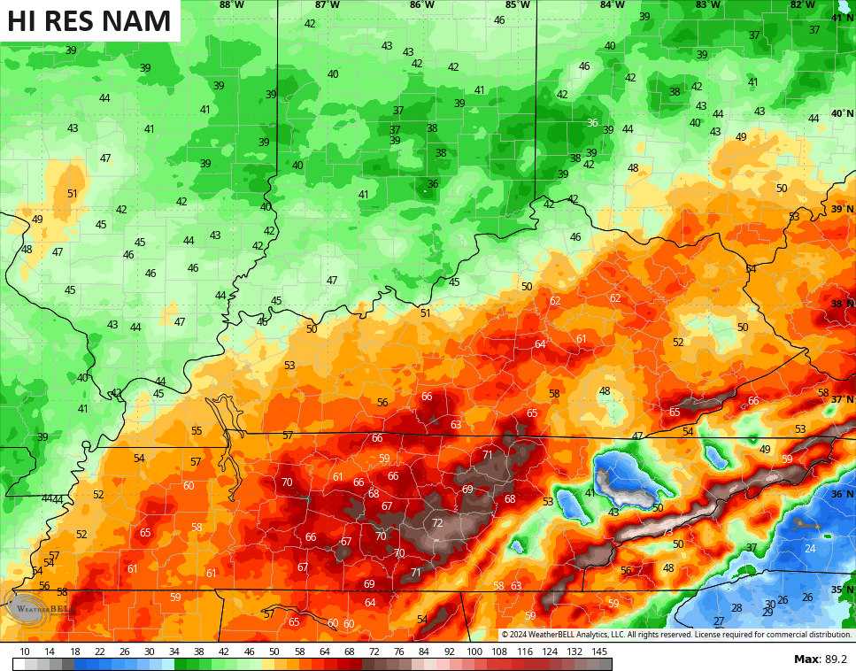
The NAM fam continues to crank out some serious wind gusts…
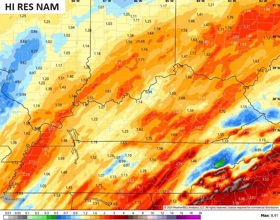
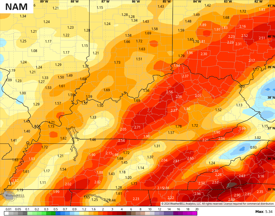
Rainfall totals of 1″-2″ should also show up for many…
The transition to light snow, snow showers and snow squalls looks to be a little faster Tuesday evening. The future radars from the HI RES NAM and HRRR both start at 7pm and show what I’m talking about…
The next system will trend farther east with a faster switch to snow Friday and Friday night. Heavy rain, high winds to snow and a shot of arctic cold will be likely with this system to start the weekend…
The next system continues to look more like a snow maker as it rides along an arctic boundary moving in late Sunday and Monday. The GFS keeps spitting out a hefty snow maker…
So does the EURO…
Every single model known to man then brings below zero temps in here behind that next week. This is the arctic air I’ve been highlighting for a while now as major blocking goes up from Greenland through the North Pole and into Alaska.
I’ll have the very latest on WKYT News tonight at 10pm on the CW Lexington and then again on WKYT-TV at 11. Of course, another big update comes your way later tonight. I leave you with your radars for the evening…

Enjoy the evening and take care.

Brrrrrrrrrr….
https://www.tropicaltidbits.com/analysis/models/?model=gfs®ion=seus&pkg=T2m&runtime=2024010818&fh=186
Hardest working weatherperson I know. Thanks Chris for keeping us updated and breaking everything down For us.