Good Thursday to one and all. The weather is about to do some serious flexing on our region with two big storm systems ahead. The first brings high winds and the chance for strong storms. The second system brings the chance for significant snows and bitterly cold temps from late this weekend into early next week.
Here’s a breakdown of the first system:
- Low pressure rolls up the Mississippi Valley and into the Ohio Valley Friday and Friday night. This low is STOUT!!
- High winds may gust to between 50mph-60mph at times in much of our region Friday.
- These gusts should top what we had on Tuesday.
- We have a window of opportunity for a few strong or severe storms racing northeastward Friday afternoon.
- Damaging wind is the primary player with those storms, but we will need to watch for a bit of spin to show up.
- Temps crash quickly from west to east Friday evening with 20s surging eastward.
- Wind chills may flirt with single digits by Saturday morning
- Snow showers and light snows will fly Friday night into early Saturday with only some hit and run minor accumulations.
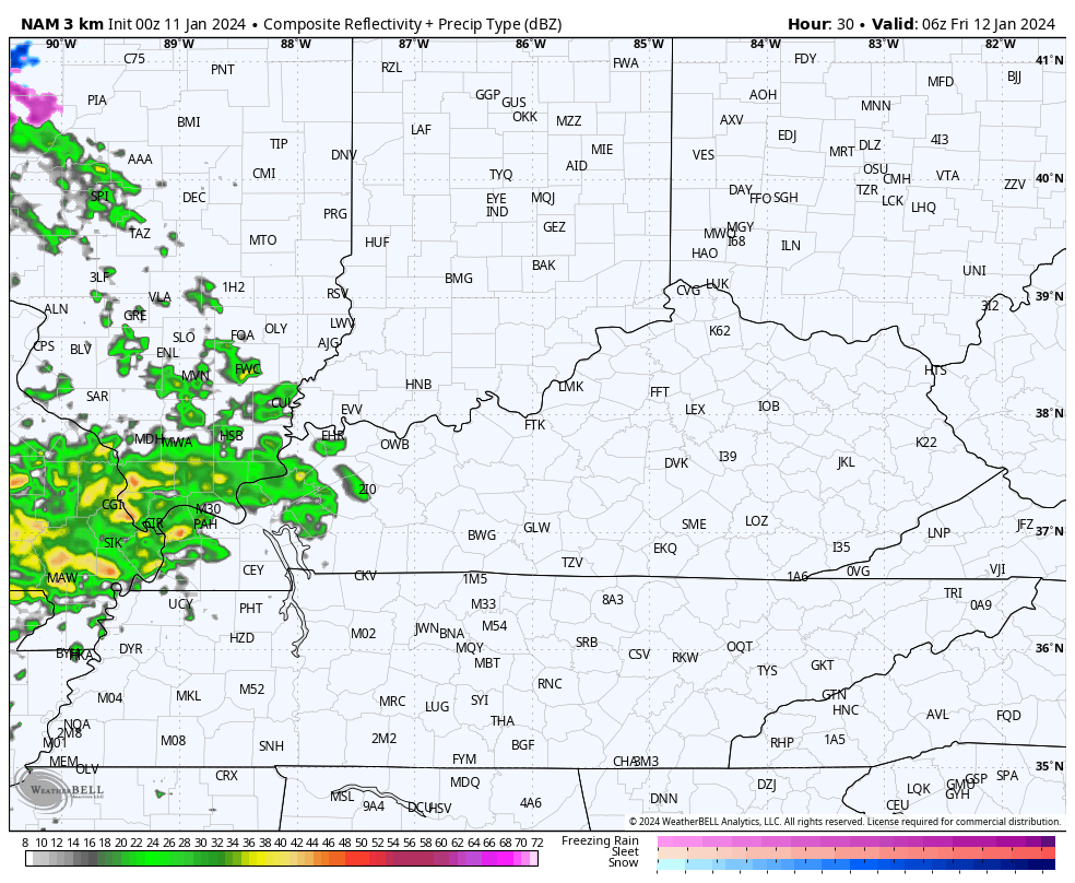
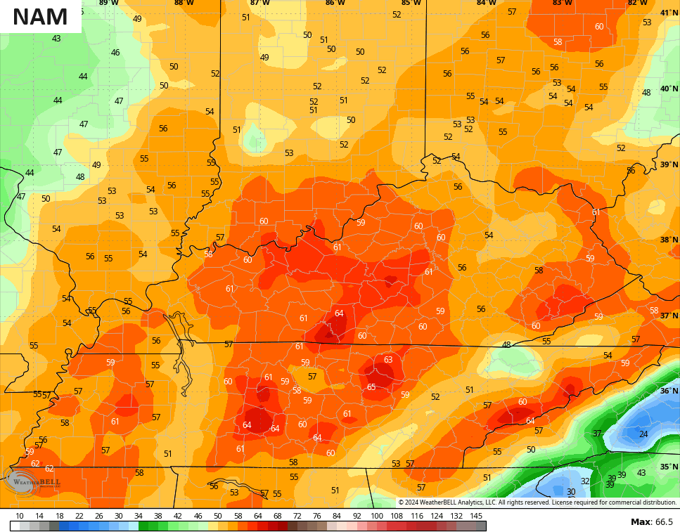
Here’s a look at our system from the HI RES NAM…
The Storm Prediction Center has a low-end chance for severe storms on Friday for parts of the region…
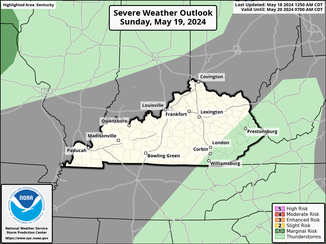
Here are the risk outlooks from the SPC…


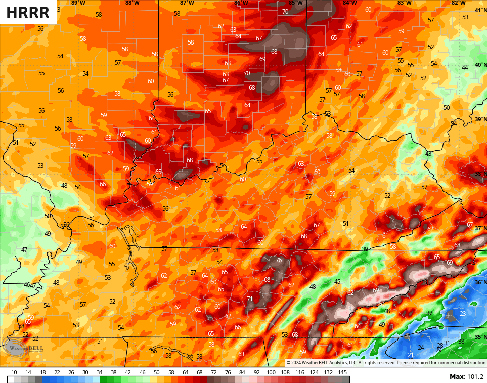
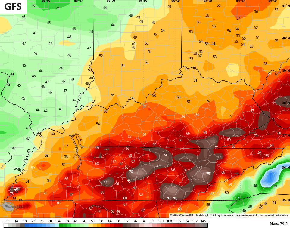
With our without severe thunderstorms, high winds will cause some issues. Gusts of 50mph-60mph look likely for many with the forecast models showing gusts exceeding 60mph at times.
The HRRR and the GFS both have some 70mph gusts…
The NAM and Hi Res NAM are lower, but not by much…

Now let’s turn our attention to the potential winter storm from late Sunday through early Tuesday. I’m not going to upgrade to a Winter Storm THREAT just yet, but I might pull the trigger at any moment today. I just want to see a bit more data before doing so.
The setup is there for a significant snowfall from Texas and Oklahoma all the way to New England with the exact route in between those two locations behind the key to how much snow we get here in Kentucky. The forecast models are in the waffle range, but they should be shedding this later today or early Friday.
With arctic air in place as snow moves in, it doesn’t take nearly as much moisture to produce snow as it would with a temp near 32 degrees. Snowfall ratios of 15-1 to 25-1 (10-1 is normal) will be possible with this system.
The Canadian Model jumped back on a sizeable event…
The GFS is also coming back around to a bigger event, but it’s still likely showing the progressive bias of the model…
The EURO is even more progressive than the GFS, but for a different reason. The bias of the EURO is to hold on too long to energy coming from the southwest and I suspect that’s what’s happening with this model run. One of the tell tell signs is that the model is the absolute slowest in bringing the initial snow eastward…

The ICON is also on board with a nice hitter…
![]()
![]()
Can we get a significant snowfall out of this? Absolutely we can. Could we, instead, get only a light snowfall out of this? Absolutely we can. We probably won’t know which of those has the upper hand for a few more model runs.
Bitterly cold temps come behind this system with the chance for temps to go below zero with dangerous wind chills that are much lower.
This isn’t a one and done type of deal as another shot of bitter cold drops in late next week into next weekend and may be accompanied by a few more snow threats…

I will have updates later today so check back.
Make it a terrific Thursday and take care.

As the low associated with the Friday system continues to deepen, we’re likely to see a repeat of rapidly dropping atmospheric pressure as we saw eatlier this week, with wind gusts in South Central Kentucky likely to top 60 mph. In addition to wind, the rapidly dropping barometric pressure is likely to cause people with conditions such as arthritis, migraines or fibromyalgia to experience elevated pain levels. This occurs as rapid pressure drop causes muscles, tendons and other soft tissue that surround sensitive joints to expand, constricting those
Thanks Chris for the update and the forecast breakdown. Looks like more wind than rain with the next system. Hopefully the storm will quickly move out of the area. I notice something different is that when a storm moves out, a ridge moves in to keep the next storm track to our west.
No comment on the impending snowstorm for early next week, but my confidence is low on a major snowstorm in our area of the state. My confidence is high on the moisture starve Arctic air for sometime next week. I guess the SSW is beginning to occur.
Have a great day Chris !
I think there is a blocking high in the Atlantic, which is keeping a trough along the east coast, and a ridge over our area, and a trough in the midwest. This would divert storms ( lows ) to our west and north, leaving our area in the warm sector. Spring like weather, with the dry cold front moving in later. Just speculation or more BS.
I hope nobody loses their electric before the arctic cold settles in.
Monday has turned into your typical wait and see snow pattern.
We almost lost our electric with the last wind event. If this happens with tomorrow’s storm, there wouldn’t be anyone willing to repair any downed lines with the temperatures next week near zero or below. Out for days if not weeks. Very life threatening.
I’ve seen the heaviest snows when the humidity was high and the surface temperature was around 28 degrees F. Over the years I’ve seen snows ( not heavy ) when the temperatures were around 15 degrees F. At zero degrees F. I’ve seen ice crystals fall under clear skies.
FWIW (which is not much), I genuinely thought the big snow stars were going to align on Sunday night. Wild stuff.
Thanks for the updates CB! We’ve already had trees and large limbs down in our area with the last round of high winds. So, not looking forward to more of that. Our power comes into the subdivision under ground, but the lines are surrounded by large trees. LG&E has done a pretty good job of trimming back trees in the last few years. The ground is soaked and lots of leaning trees everywhere. Still looking forward to the potential for a nice snowfall in my neck of the woods though!
All the electrical and telephone ( not fiberoptic ) DSL internet are wired on trees and utility poles, but are buried on my property at my expense. Very primitive setup. My electrical coop. won’t bury the lines because it’s too expensive. Putting money before lives. I would purchase a generator to run the whole house, but there is no natural gas where I live, so I have a storm responder gasoline generator that just runs the basics.
I’m keeping an eye on another winter storm threat for early next week. Similar to the past system, we likely need the upcoming storm tomorrow arrive before data gets a better handle on how the Sun – Tuesday storm evolves.
It appears the most likely track will be through the lower OH Valley and Tennessee Valley.
Shut up
This would make the whole state happy if you like 0 degrees and 10 inches of snow..
https://www.pivotalweather.com/model.php?rh=2024011112&fh=150&dpdt=&mc=&r=us_ov&p=snku_acc-imp&m=gdps