Good evening, folks. Our next snowmaker is on the way to the region and will put down more snow across much of the region. This will also unleash another round of bitterly cold temps for the coming weekend.
Before we get to all this, Kentucky had the coldest air of any of the lower 48 states today. Congratulations to Monticello for hitting -22 degrees…
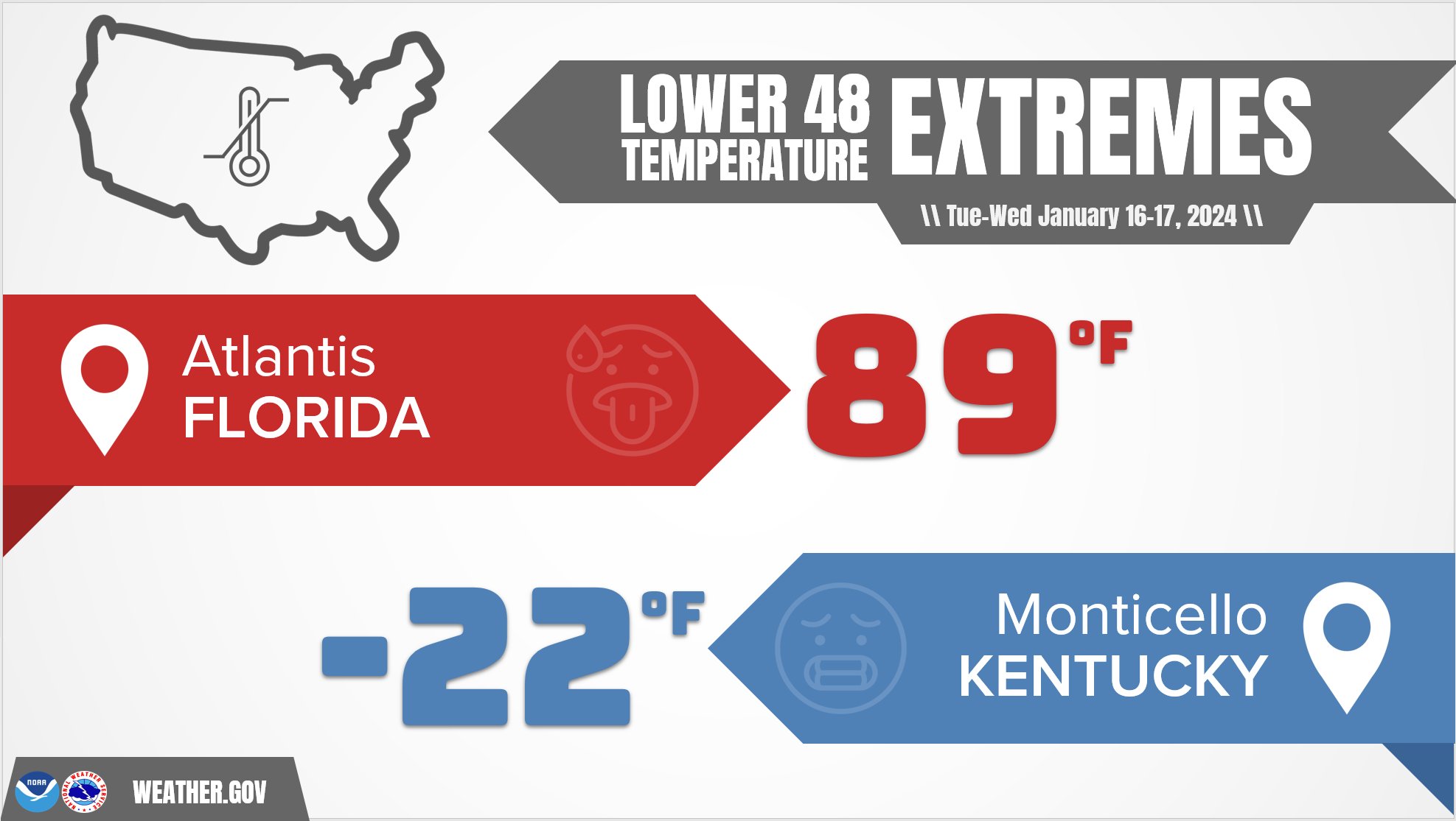
That’s insane!
Snow and a wintry mix develops across southern Kentucky Thursday afternoon with snow expanding north and northeast through the evening as low pressure slides to our southeast. Another band of snow then drops in from the northwest Thursday night and early Friday, bringing widespread light snow with it.
Once that moves through, a strong northwest wind flow kicks in as arctic air returns. This northwest flow will have fairly widespread snow showers and squalls with it from late Friday into Saturday morning, especially across the east.
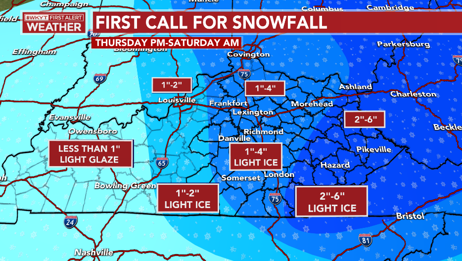
My snowfall map remains the same from earlier today…
A Winter Weather Advisory is now out for most of Kentucky and I think there’s a chance for an upgrade to a Winter Storm Warning for parts of the east…
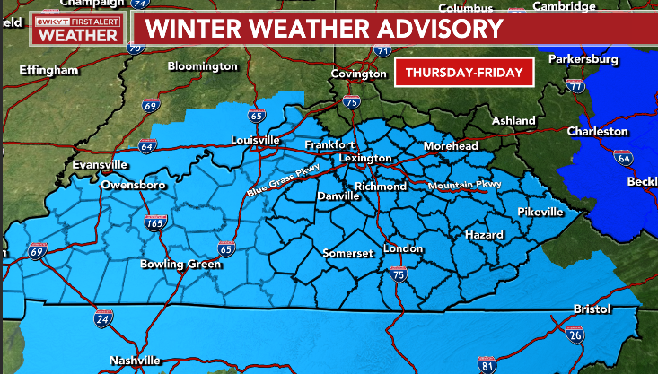
Notice the absence of anything in northern and northeastern Kentucky. Those area are covered by the NWS offices in Wilmington, Ohio and Charleston, WV and they have a really difficult time in getting winter weather products out to match up with the rest of the state. I’m sure they’re waiting until the day of to put them out, but the problem is that map gives people in those counties a false sense of security. The general public looks at that and thinks ” It’s not going to snow where I live”. Spoiler: It’s going to snow where you live in those counties.
I still like the numbers from the GFS and ICON…

![]()
![]()
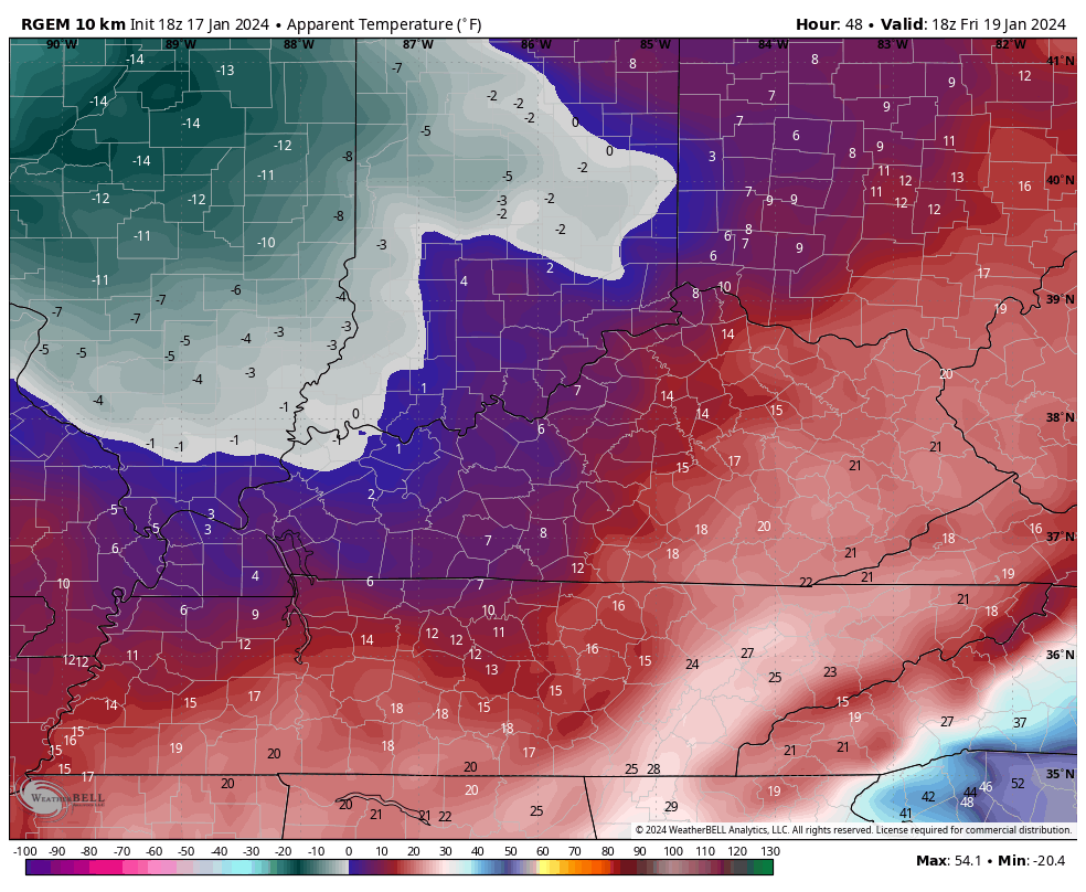
Bitter cold temps crash back in behind this with the chance for below zero temps once again this weekend. Wind chills are a big factor. Watch the numbers crash from 1pm Friday through 8am Saturday…
30 years ago right now, Kentucky was in one of the worst periods of winter weather on record around here. January 1994 is legendary as we had a major shutdown snowstorm ongoing at this hour with the coldest temps ever recorded in Kentucky waiting in the winds. Shelbyville would record -37 degrees which is still the coldest ever recorded in Kentucky.
Take a trip back in time with this WKYT newscast…
That was about 4 years before your friendly weatherdude started his career at this very same station.
I’ll see you guys later tonight with an update. Have a good one and take care.

Thanks Chris for the video
I recall seeing the blizzard warning scroll across the TV, thinking it was on a channel based in a more north-western sated and then realized it was on WKYT. That warning was still a few days out and got worse with each model progression.
state
So wkyt had blizzard warnings????
I think the HRRR and NAM are a little to bullish on the freezing rain, we shall see.
Hopefully. Good news “should” be not enough precipitation though to be a big tree or line issue.