Good Friday, everyone. Rounds of snow continue to target central and eastern Kentucky through the day with many areas picking up a few to several inches of snow. Bitter cold comes in later today and continues into the weekend as temps likely go below zero.
Snowfall as of this 2am writing was already at a general 1″-3″ for much central and eastern Kentucky with the heaviest snows from the BG Parkway through the Lexington metro and into eastern and northeastern Kentucky.
Another wave of snow moves through this morning into the early afternoon, dropping another inch or two. Once into the afternoon and evening, arctic winds out of the northwest will touch off snow showers and squalls across the eastern half of the state. Some of these linger into early Saturday with additional light accumulations.
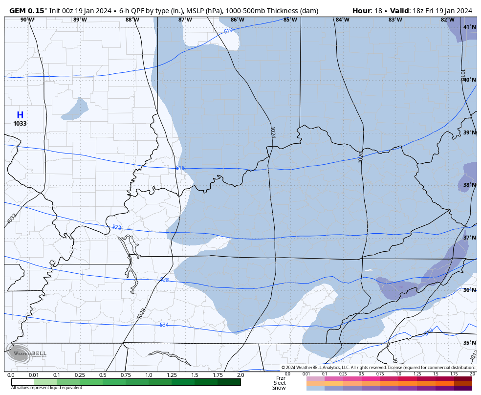
The GFS and Canadian models have a decent handle on this…
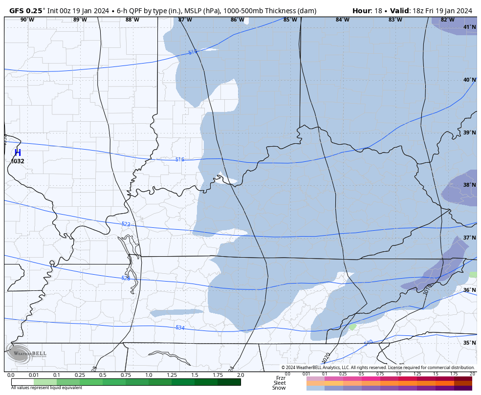
Models tend to underdo the northwest wind snow showers and squalls, so keep that in mind. With gusty winds out there later today and tonight and a fluffier snow texture, some blowing snow will be a good bet.
Arctic flurries will be likely into Saturday afternoon in these same areas.
Here are your radars to follow the action…

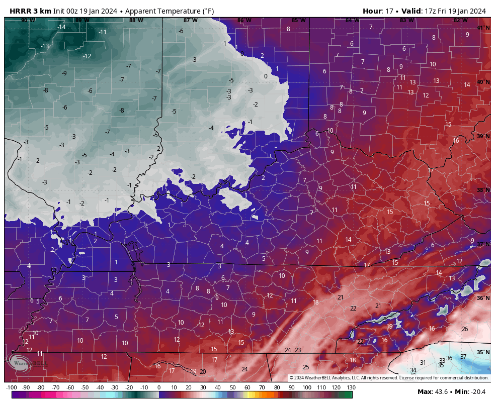
Bitterly cold winds will be noted this afternoon through Saturday as thermometers crash. Saturday morning lows will range from 0 to 5 above in many areas. Wind chills will be brutal during this time and may be near -15 late tonight and Saturday morning.
This animation shows wind chills from Noon today through 8am Saturday…
Actual lows on Sunday are likely to go below zero for much of Kentucky. The models were way too warm with the lows a few days ago when we went below zero and they are likely too warm on Sunday. That said, the GFS is showing temps going below zero in many areas…
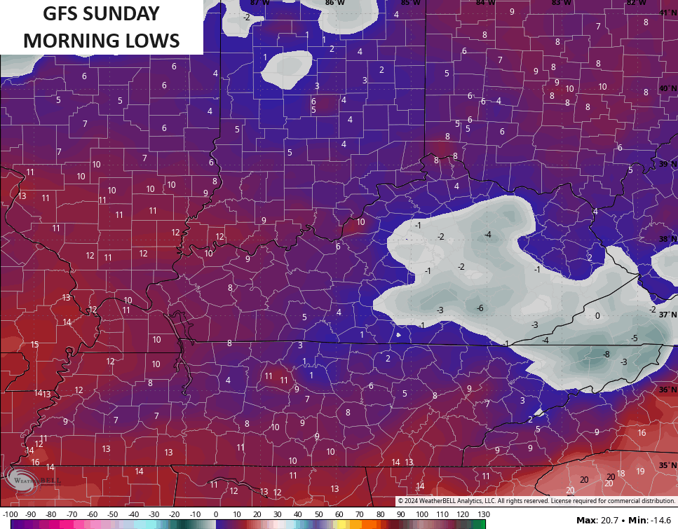
There’s the chance again for -10 to -15 actual air temps to show up for the second time in less than a week.
No matter how you slice it, this is one harsh week of winter weather across our part of the world.
Next week brings a new pattern as this winter pattern relaxes, but that doesn’t mean we aren’t in the line of fire for more extreme weather. My concern for heavy rain and a high water threat is growing for ther middle and end of the week.
Moisture streams back in here late Monday into early Tuesday and there’s the chance it starts as freezing rain before rain fully takes control. Once it takes control, it may really do so through next week and, perhaps, into the following weekend.
This is a prolonged period of rain aimed right at our region…
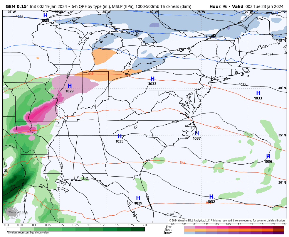
Several inches of rain may fall next week and the model forecasts are concerning…
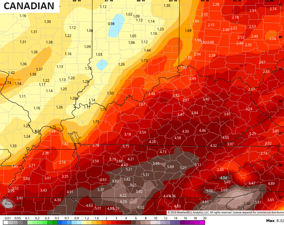
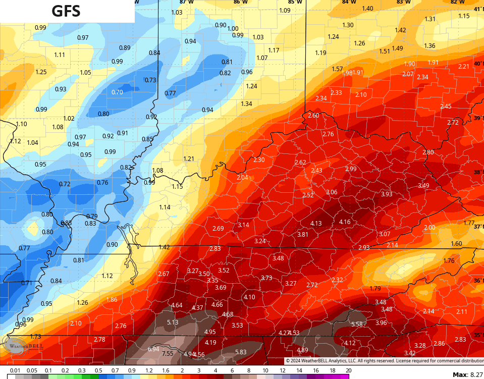
With a fairly deep snowpack and a frozen ground, we really need to watch this heavy rain setup very closely.
I’ll drop by for your normal updates later today. Make it a good one and take care.

The snow & rain drought is over for many folks.For me personally I could of used a little more snow.
Anyway I am getting that itch to go out and do some planting.
The projected heavy rains are concerning, especially in western and south central Kentucky. These areas have not had an insulating blanket of snow, leaving the ground totally frozen. I would expect to see areal flood watches issued for these areas before long.
Snow overachieving a bit in S. Illinois and S. Indiana thanks to a band of low-level frontogenesis (intensification of a boundary/gradient).
A nice band of snow will swing across the lower OH Valley the next few hours.
Thanks Chris. We had additional snow last evening of 2 inches. Really beautiful, as this snow is covering the many tree limbs around our property. Glad all the snow lovers in the eastern part of the state are happy. Maybe down the road western part of the state will receive their share.
Have a great day everyone !
North Richmond got 5″ total from the previous events and 5″ from this one, so already a few inches more than all of last winter. Nice and fluffy too!