Good Friday, folks. We have another mild and windy day taking shape, but rain is set to push in later tonight and into part of the weekend. This rain may put down some hefty totals in some areas as this active setup is ahead of a change back to winter.
Our day will feature highs in the mid 50s to low 60s with mostly cloudy skies and gusty winds. A southern system will throw widespread rain and some thunder into the area tonight and early Saturday. After a break in the action, another round of rain looks to impact the southern and eastern parts of the state Saturday night and early Sunday.
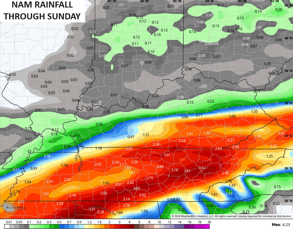
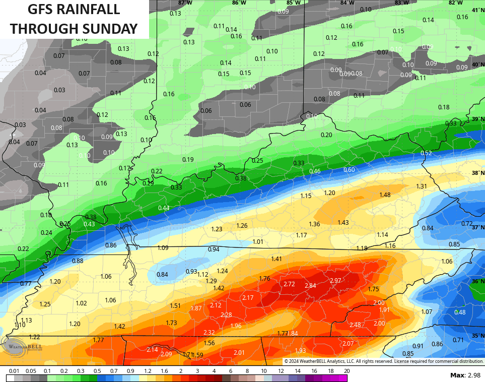
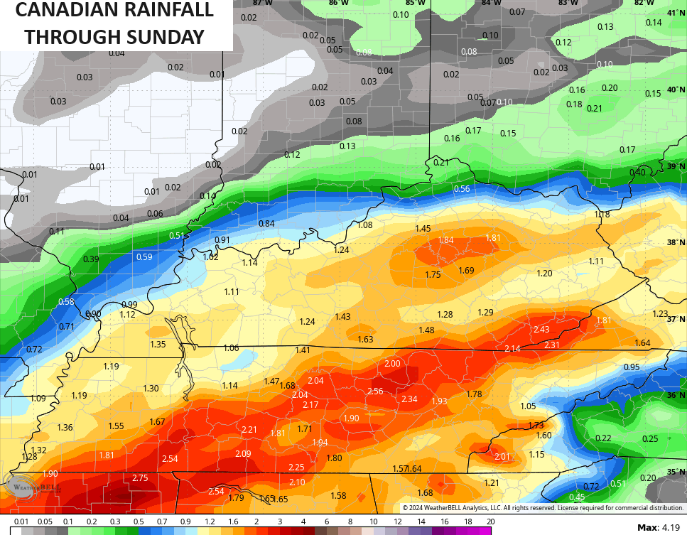
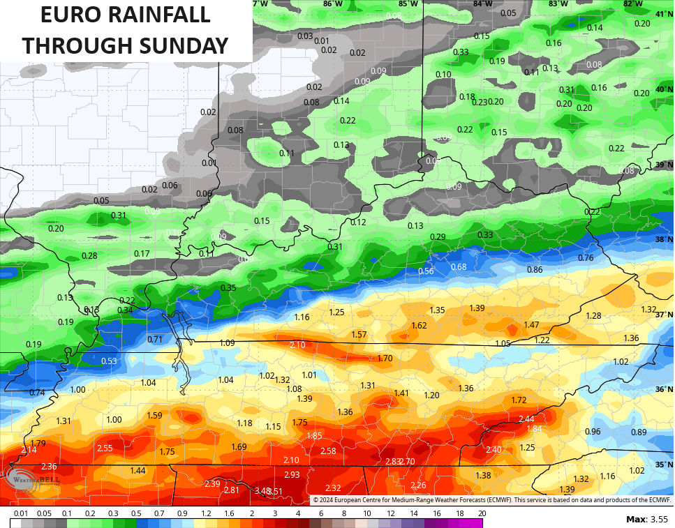
The models are spitting out some hefty totals…
It’s all about the track of the low with the next system Monday and Tuesday. Low pressure is likely to move from the lower Mississippi Valley toward southeastern Kentucky and into West Virginia. This low wraps up pretty good along the way before transferring energy to a coastal low that takes over.
The GFS has consistently been showing rain changing to a period of west snow late Monday through Tuesday morning…
The EURO is now similar…
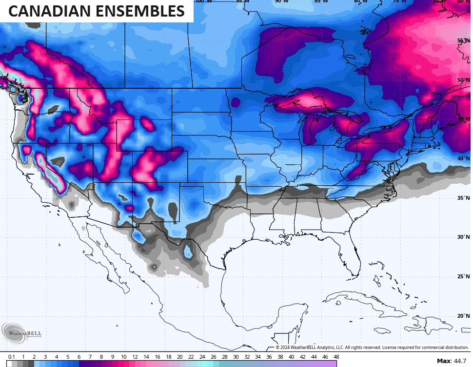
The Canadian is much weaker with this system, but it’s trending toward the overall setup from the GFS…
Another system moves in here by Thursday and Friday, but the models really don’t know how to handle this one just yet. Arctic air pours into the country with this, so expect some wild swings in the models.
Snow chances are going to really showing up on the Ensembles for the next few weeks…
I won’t bore you with another run run of the EURO Weeklies, but they have not changed a bit through March.
I’ll have another update later today so check back. Until then, here are your radars to track any showers in from the southwest…

Enjoy your day and take care.

Thanks Chris for the update. Hoping for some rain, but looks like it may stay south of my area. Don’t know.
Looks like a good chance of a phasing storm developing along the east coast, with the possibility of a major snowstorm for New York City ? Something to watch.
Our chances for any major snowstorm have really decrease in recent days due to the transition from ENSO / El Nino to ENSO / neutral, and eventually to ENSO / La Nina later this summer.
Groundhog’s prediction for an early spring may pan out ? LOL……
Have a great day !
The transition to a cooler pattern (not super notable cold), is right on time into the third week of February. Latest EPS resembles my thoughts nicely from the last few weeks.
Attention turns to a SECOND SSWe of the season — it appears the main vortex lobe will move over Asia which is where the coldest air vs. normal will subsequently move the next few weeks.
This should still help keep blocking around and the cooler pattern East through the end of February.
Thanks, Chris
Here’s the link to the ENSO February update from the Climate Prediction Center:
https://www.cpc.ncep.noaa.gov/products/analysis_monitoring/enso_advisory/ensodisc.shtml
Major ocean surface cooling has taken place over the past few weeks, and the CPC is predicting a 55% chance for La Nina development by June. El Nino’s impact on the tropics was significant, especially in the Caribbean, where El Nino-related shear pushed most Atlantic hurricanes far out to sea, but its effect on our region has been minimal. I believe this is a trend, and I expect La Nina’s impact will be less than past incursions.
I liked last summer’s weather.
If we have a repeated performance I will take it.
Not me. We need more heat and just a bit less rain.
We need more rain going into a windy March, and then it can settle down and get into the low 90’s. # teamsummer.
Joe I read the article thanks but can you tell me if that occurs how does it affect our weather??
Crystal, Going from an El Nino to neutral would mean the spring’s severe storms would be more frequent. After that we could have a hot and dry summer. When we transition to a La Nina sometime late this summer, we could have a mild and stormy fall and unfortunately a winter with less snow chances. El Nino in the positive would have brought us a colder and snowier winter this year, but that didn’t happen the way it use to. I’m very disappointed, but this is the new normal we all have to get use to. Maybe it will change back, but not in my lifetime.
Crystal, I must give Joe all the credit, as I learn a lot from all of his post.
I learn from Joe too and you and a lot of our friends here at the weather blog. I appreciate their views all of you. I do miss our big snowstorms of the past and seem then the weather was easier or more certain to forecast then now I don’t envy Chris at this time trying to make sense of it all and he always does. He is such a good teacher.
I don’t think it will change back for awhile either Schroeder welcome to the new normal weather that’s is anything but normal. I bet we have more severe storms too.
A couple of Severe Thunderstorm Warnings and even a brief Tornado Warning were issued late Thursday afternoon in North Central IL, well to the west of the Chicago Metro Area.
Southern Wisconsin had the most organized severe weather, with several Severe Thunderstorm Warnings and a couple of Tornado Warnings south of Madison, one of which was cla*ss*ified as a PDS (Particularly Dangerous Situation).
Thursday’s high of 59 degrees at O’Hare Airport was just three degrees shy of the record high for the date. Friday’s record high of 56 is certainly within reach.
Mike, I would expect that will happen here as we switch to ENSO / neutral. I don’t like the springs in Kentucky. Flowers usually freeze out and the tornadoes breakout.
Thanks Schroeder! Three factors driving our region’s weather include deeper pressure gradients between areas of Low and High pressure, increased instability due to rising dewpoints, and an unpredictable split jetstream flow. These factors could make meteorologists question their career path!
Joe, it’s really changed in the past 60 years. The weather this time of the year use to be more interesting, and I never heard of a ‘ split flow ‘ from the meteorologist I listened to back in the early 1960’s. We almost always had a big snowstorm around high school basketball sectional time, postponing the games. New Normal now we have to except. And yes, if we had this boring weather back then I for myself would not be interested.