Good Thursday, folks. A cold front is working into the region today, bringing showers and a few thunderstorms along for the ride. There’s a brief taste of winter waiting behind this boundary before another big spring bounce back takes place.
Let’s begin with today and hit the fast forward button.
Temps range from the mid 50s to low 60s on a gusty southwest wind kicking up ahead of our cold front. Isolated showers will be noted this morning with more widespread showers and storms going up this afternoon and evening. Locally heavy rains of 1″ or more can show up, but most areas pick up a half to 1″ of rain.
Here are your radars to follow today’s showers and boomers…

Chillier and drier winds blow in for Friday with a mix of sun and clouds taking over as highs hit 50-55 for many.
A clipper looking system then dives in from the northwest into Saturday and brings a quick-hitting band of light rain and light snow across the state. The Hi Res NAM only goes through 7am Saturday, but the future radar shows our light snow…
The GFS shows the rest of Saturday…
There’s a chance for some very light slush to show up for those under this small band of light snow. Highs struggle to get out of the 30s.
The numbers bounce back in a hurry on Sunday and then reach the 60s into the first half of next week. This is a strong southwest wind flow ahead of a potent storm system developing in the Plains and heading toward the Great Lakes.
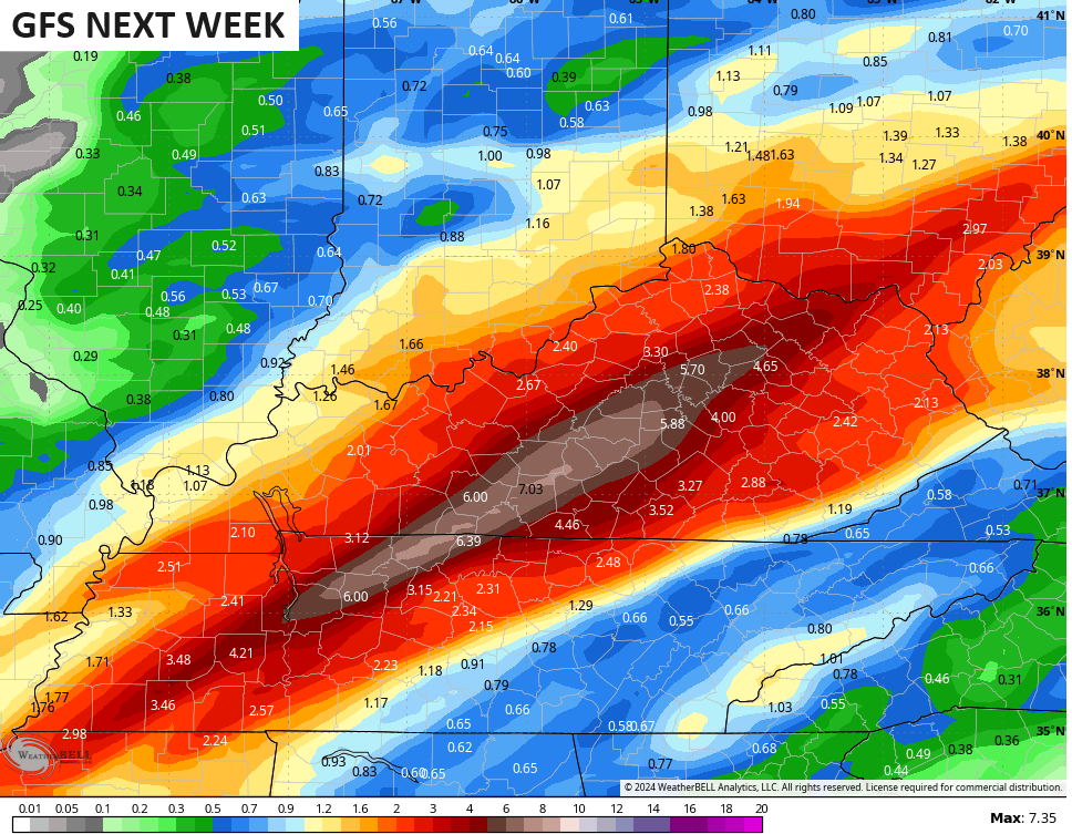
This puts our region in the line of fire for rounds of rain and thunderstorms from Tuesday through early Thursday. The chance is there for strong to severe storms before cold air crashes in behind a cold front…
The GFS is spitting out some major rains with this storm system…
The overall pattern for the second half of February is not what was expected, and the extended and seasonal models gave us absolutely no help and we REALLY bad. I suspect the reason is the unprecedented climate and state of the oceans. We know we had a big time El Nino, but the overall base state of all the oceans was super warm to begin.
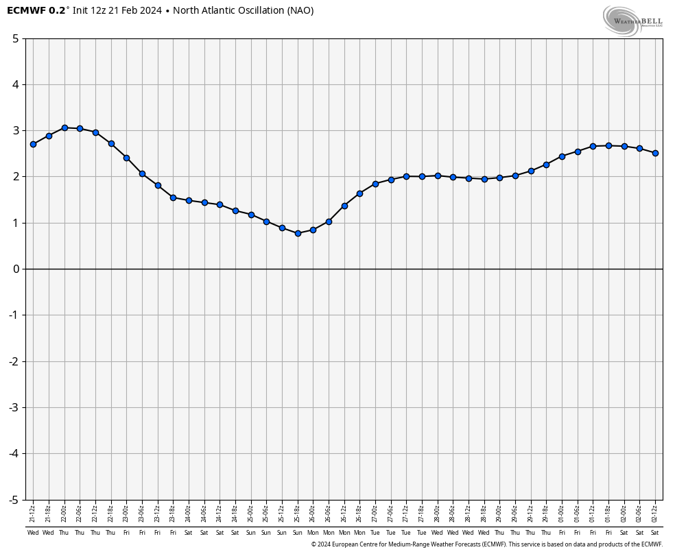
The models had all been forecasting significant blocking showing up for the second half of this month with a -NAO, -AO, -EPO and a +PNA. How did those work out?
The NAO is strongly positive and forecast to remain there…
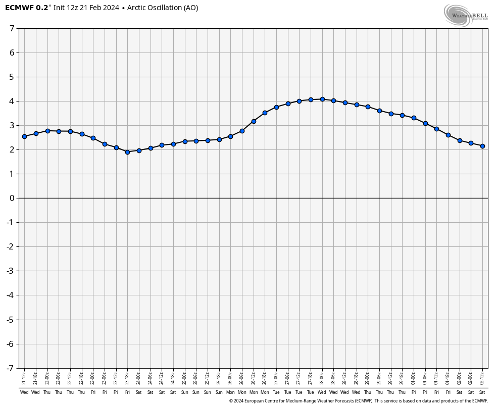
So is the AO…
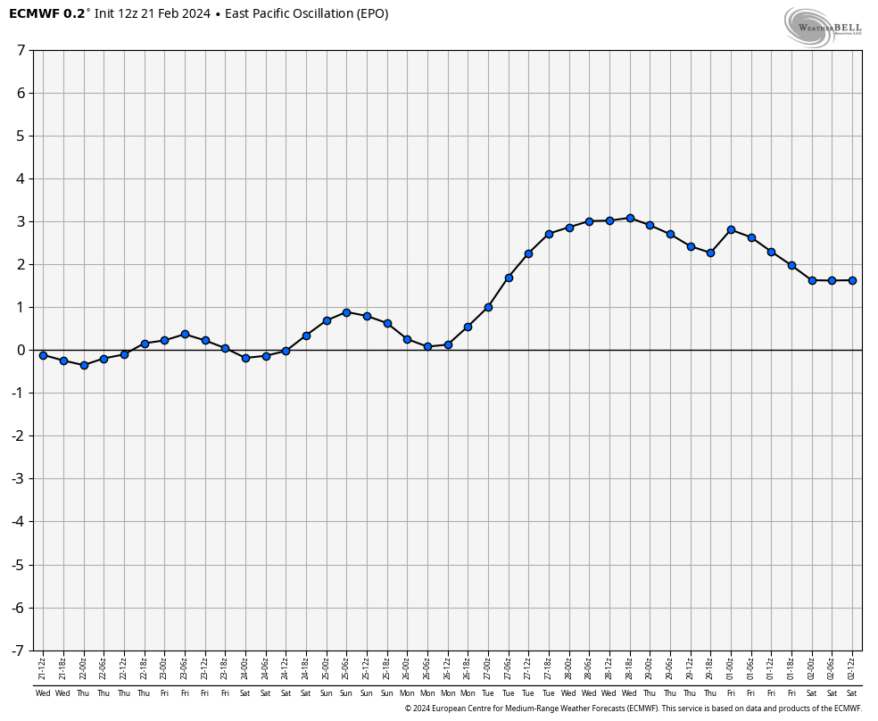
The EPO is neutral and going into positive territory…
The PNA is also neutral and forecast to go strongly negative…
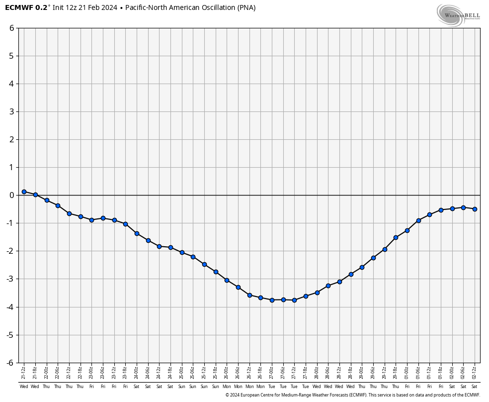
Every single index is just the opposite of what every single ensemble and extended model was forecasting.
Now, watch all those signals show up in March and you will see me lose my ever-loving mind.
I’ve got another update coming later today, so check back. Have a great day and take care.

Don’t let the armchair mets and haters get ya down, dude.
Thanks for the update Chris. Look at it this way, the West has really made great progress, if not ended a drought that has been going on for years, but I hope it ( the drought ) doesn’t settle in our part of the world in the next few years.
One of these years we will have a winter where the El Nino will form along with a positive PDO and the snows will fly in our part of the world.
Have a great day everyone !
I wondered what had happened to all of the ‘blockiness’ that was discussed here for mid Feb-mid March!! Looks like the groundhog might have been right!
Rodents are not meteorologists.
And meteorologist are not rodents.
Chris explained that very well in his blog this morning. Old folklore sometimes pans out.
Thunder and lighting with heavy rain here in my neck of woods.
I hope we get some of that rain here in Maple.
Chris- thank you for explaining your thought process on why things didn’t pan out how the models expected! Appreciate it and you!!
Thanks Chris for the explaining why didn’t the polar air didn’t metalized.
Our new normal continues to play havoc with forecast models, especially the long range versions, and one big culprit are our warming oceans. Record warmth continues, especially in the equatorial Atlantic, which is the area where many Atlantic hurricanes get their start. Ocean water temperatures there are already at levels typically seen in July, so any tropical depressions that form there will get an immediate kick start, and since the El Nino-spawned shearing forces in the Caribbean have dissipated, we’re very likely to see an above normal Atlantic hurricane season in 2024.
Agree, that we will have an above average tropical storm season. I already gave the warning to my Sister and Brother in law, who live on the Gulf coast of southwest Florida. Watch and pay attention to any Hurricane watch or warning I told them.
The rain we had this afternoon was very light and only amounted 0.14 ” The rain system is giving the best rains well to our north, and now is almost out of my area. The precipitation pattern has not changed for almost two years now.