Good Sunday, everyone. Spring is surging into the region today with temps taking off into the next few days. This mild surge will lead us into a very active pattern that can put down heavy rain, bring strong storms and, eventually, unleash a touch of winter weather.
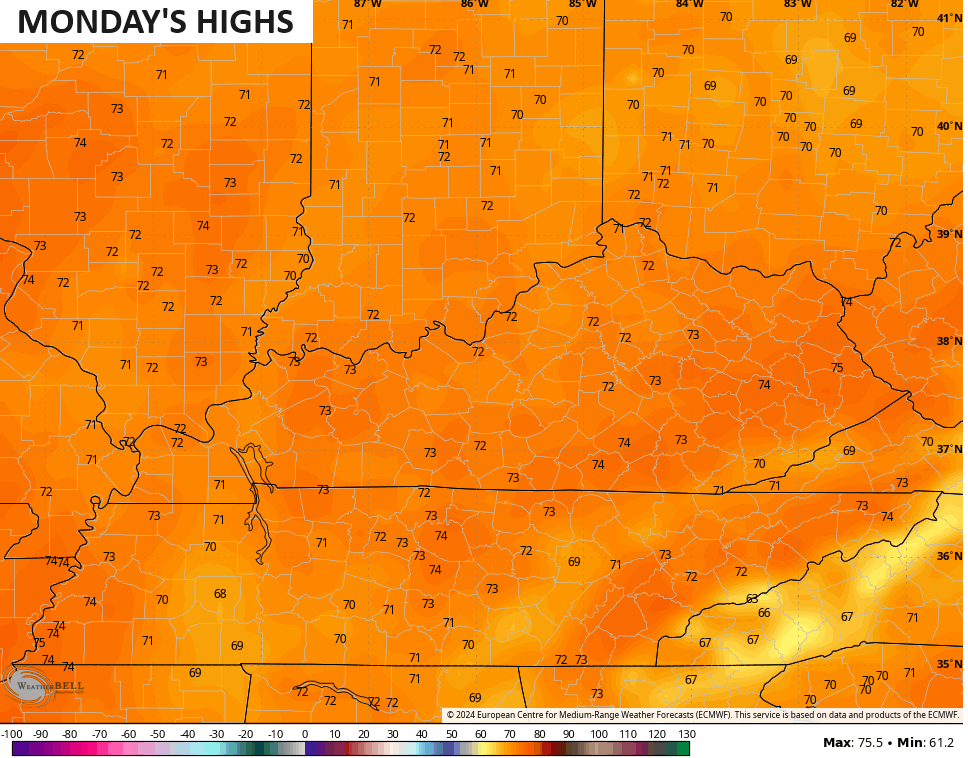
Temps out there today take off and reach the 60s across the entire region with a few spots hitting 70. Temps in the 70s are likely by Monday…
Here’s a quick breakdown of the pattern that follows:
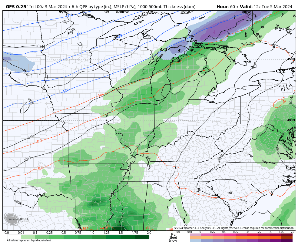
- A cold front moves in on Tuesday and brings showers and thunderstorms in here. A few of the storms may be strong.
- Low pressure develops along this front and moves in on Wednesday. Widespread rain and some thunder looks likely.
- Thursday looks mainly dry and calm.
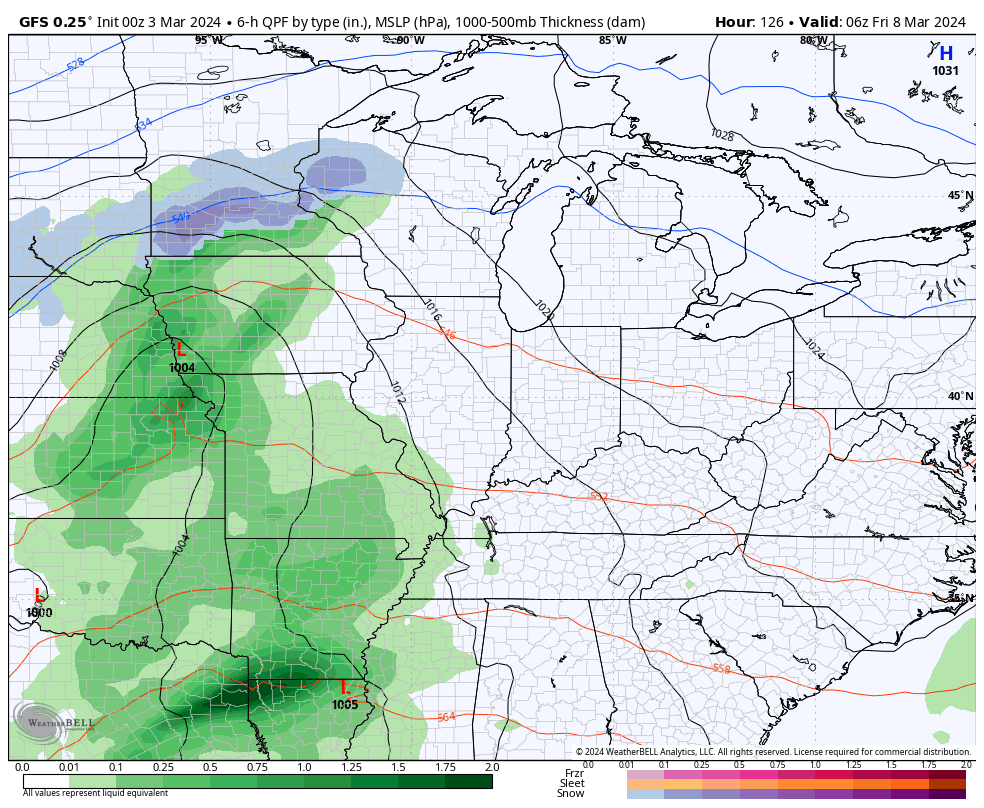
- Another potent storm system then develops and rolls through here Friday into the weekend. This brings rounds of rain and thunder back into the area, especially Friday and Saturday.
- Much colder weather then drops in behind the departing low on Sunday and may bring some light snow and snow showers into town.
- A general 1″-3″ of rain is a good bet from Tuesday through Saturday. Locally higher amounts will be possible.
The forecast models are all very similar with the overall setup.
Here’s the GFS with the Tuesday-Wednesday system..
And here’s the storm coming for Friday into the weekend…
I’ll drop by with another update later today. Make it a good one and take care.

Thanks for the outline Chris. Sounds now that we are in for a wet / stormy week. Well we still could use more rains as the summer / growing season following El Nino winters usually turns out drier that normal.
Enjoy your Sunday everyone !
The creeks are pretty full. The soil for several inches appears saturated. You’re right about late spring & early summer extended dryness affecting new plants. We’ll see, I guess.
Temperature wise I would love a repeat of last summer.
I prefer it a bit hotter.
The chances are that your wish will be granted.
Usually after an El Nino winter, one that reacts with the atmosphere, we have an early hot and dry spell. Back in June 1978 we had temperatures of 102 degrees with no rain for a week. This was in Indiana where I had my nursery. It was a week of water water water to keep my nursery stock alive.
Weather history was made in February for the Chicago area, as it was the warmest February ever for Chicago in over 150 years of weather records. The average temperature of 39.5 degrees was a ridiculous 10.7 degrees per day above normal, and broke the previous record of 39.0 degrees set way back in February of 1882. Only three of the 29 days averaged below normal.
Meteorological Winter wound up being the fifth warmest winter ever, with an average temperature of 34.9 degrees, which is 6.8 degrees per day above normal.
Needless to say, snowfall was a huge disappointment, with only 18.5 inches recorded during the three months at O’Hare Airport, and even less at the NWS Forecast Office in the SW Suburbs.
Here is the link for the monthly summary and seasonal summary: https://weather.gov/lot/February_2024_Winter_2023-2024_Climate_Summaries
Mike, only 18.5 ” of snow. That would be a snowy winter here in south central Kentucky. I recorded exactly 5 ” here in Maple. Our average snowfall is 13, ” but we haven’t achieve that amount since winter 2014 – 15.
With La Nina ( watch ) for next winter your area may make up the snowfall deficit. Our only good chance was this past winter, but the El Nino didn’t react the way it did in 2014 – 15.