Good Saturday, everyone. We have a very active setup taking place as we slam the door shut on March and kick off the month of April. This pattern brings some awesome spring air, the threat for severe weather and even the chance for a touch of winter weather.
Let’s begin with our Saturday and hit the fast-forward button. Temps today hit the upper 60s to low 70s for most of the state on a strong southwest wind. This is ahead of a boundary sliding in from the northwest, bringing a storm or two into the region. The best threat for a few storms may wind up being this evening.
Easter Sunday finds our front on top of northern Kentucky with the chance for a storm or two rumbling across the region. With temps in the 70s for many, this front may get a little more active by the afternoon and evening for the northern half of the state.
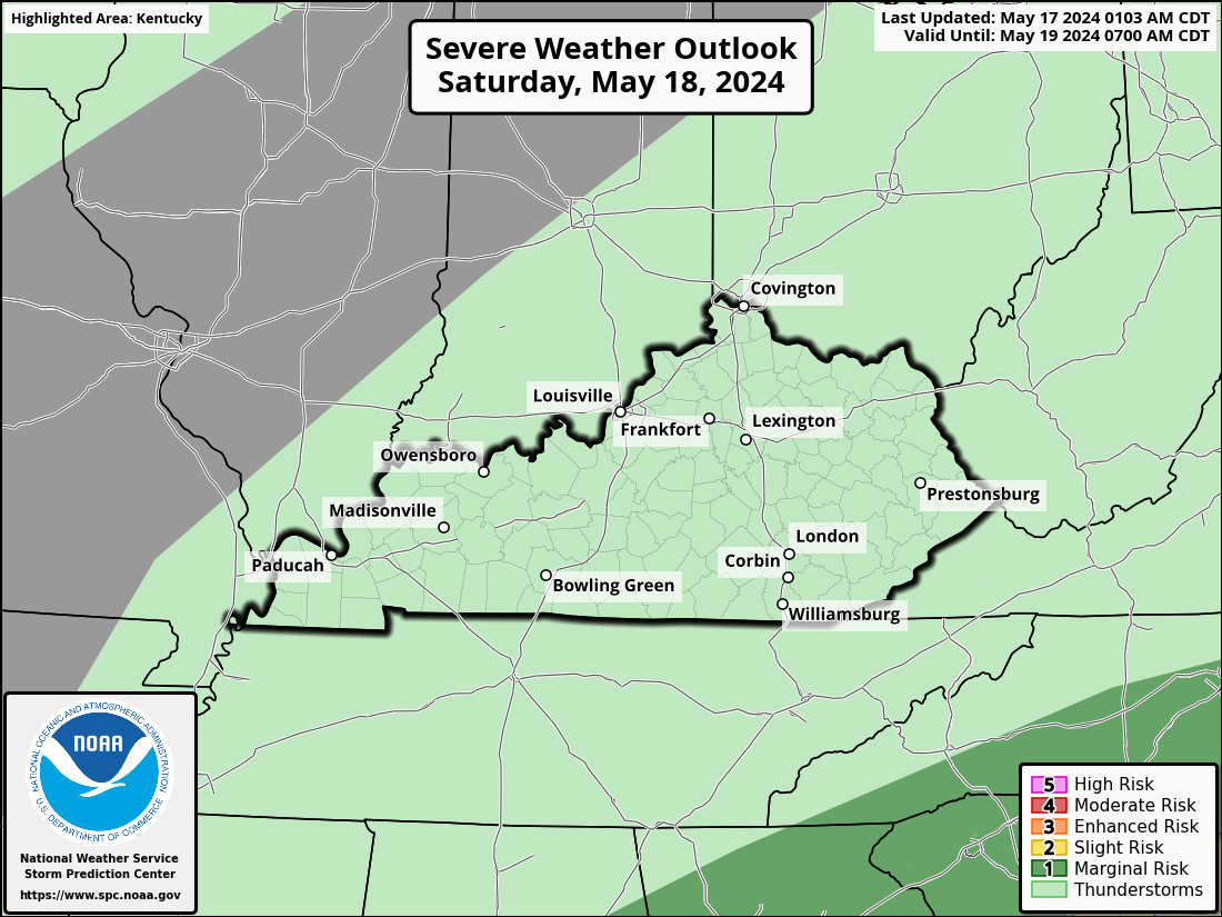
The Storm Prediction Center has this area in a low-end risk for a few severe storms going up…
A strong low pressure rolls out of the Rocking into the mid-Mississippi Valley on Monday. Temps ahead of this surge deep into the 70s across Kentucky as that southwest wind continues to do some work.
Scattered showers and storms will be around, but this doesn’t look like all day stuff by any means. Storms become more common late day into the evening, especially in the west and north. This is where the Storm Prediction Center has outlined in the Monday Severe Weather Outlook…

As our low rolls into the Ohio Valley on Tuesday, the severe threat expands into much of our region. This is just outside the traditional 3 day Severe Weather Outlook, but the SPC shows this threat covering much of Kentucky and surrounding areas…

The Tuesday threat is the most concerning with all modes of severe weather on the table. Damaging winds, large hail and a few tornadoes may all factor into the day.
Behind this system comes very cold air as a potent upper level system moves in for Wednesday and Thursday. This brings rain showers and the chance for some snow showers in here. NOOOOOOO!!!!!!!
Here’s the EURO with the evolution of everything we just talked about…
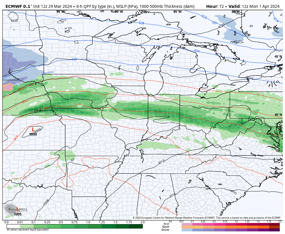
That’s a nasty setup, folks.
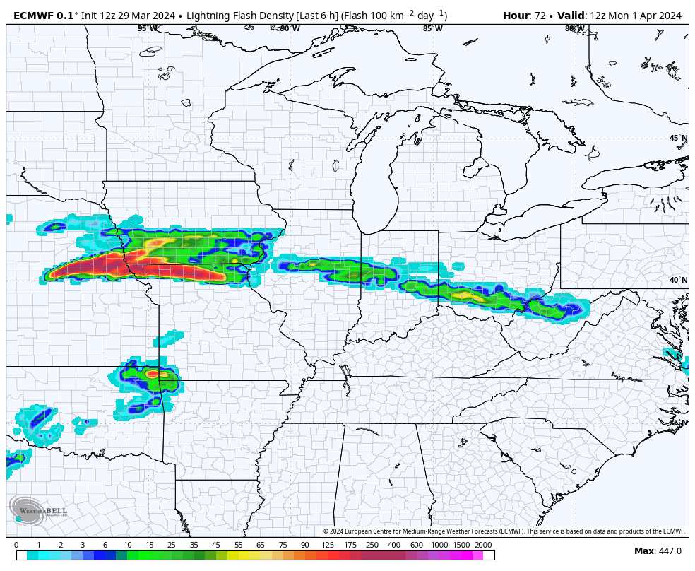
Check out the all the lightning the model is spitting out with the rounds of strong to severe storms through Tuesday night…
The air behind this is looking colder and colder as we get closer. The models are also keeping the colder than normal temps hanging through the end of the week…

If you recall, the EURO Ensembles were the first to sniff out these cold shots from a few weeks out. Those same ensembles looking ahead to the second week of April have above normal temps…

I may drop by for another update later today. Until then, here are your radars to follow today’s scattered storms…

Have a good Saturday and take care.

The ensembles are liars. No snowflakes nor significant cold.
It depends on your definition of cold air at this time of the year.
I would not be surprised to see the SPC designate south-central KY as Enhanced on Tuesday. The mid-level and upper-level jet stream winds will be aligned SW to NE, upping the chances for supercell development, and dewpoints over the Gulf states right now are crazy high.
The amount of severe weather in our area will depend on how much of that juicy air makes it into our area.
I hope that severe weather stays out of KY all together.