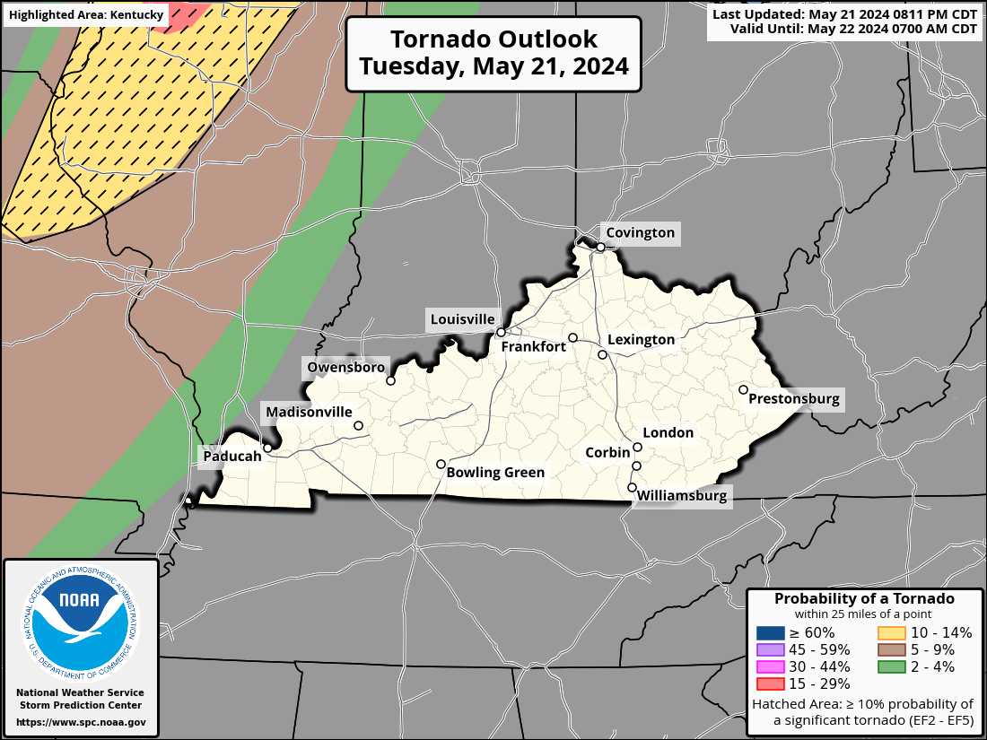
Good evening, folks. I wanted to stop by for a quick drop in to talk about a slight increase in the severe storms risk for western Kentucky. This action is along and ahead of a system rolling in from the west.
Temps in the west spiked to near 80 degrees this afternoon on a strong southwest wind. This is aiding in the development of scattered thunderstorms that may go severe. The Storm Prediction Center continues with a low-end risk for severe storms in the west…

Damaging winds and large hail are the primary players.
Some of these storms may have just enough shear to produce a tornado or two. Here’s the Tornado Outlook from the SPC…
Eclipse day clouds are still expected to be an issue. While some breaks are a good bet, the models continue to highlight clouds through the afternoon…
After that, rounds of strong storms look to bring a lot of rain into the region. This starts Tuesday and goes through the end of the week with another round early the following week.
I leave you with your storm tracking radars for the rest of this Sunday…

Current watches

Possible Watch Areas

Have a great day and take care.

Be careful out there tonight.
Does anyone know a site that shows you the times apox for local areas in Ky??? Bigger cities are easier to find but smaller not so much. If anyone has a good eclipse site I hope you will post it if it’s alright with Chris??
Crystal, check this link. Once you have centered the map over Kentucky, zoom in as close as you need, and when you touch the map, it will bring up a box containing all of the timing info for that spot:
http://xjubier.free.fr/en/site_pages/solar_eclipses/TSE_2024_GoogleMapFull.html?Lat=36.83973&Lng=-85.40389&Elv=237.0&Zoom=8&LC=1
Also, the site’s time is listed in UTC, which is similar to Greenwich Mean Time.
This site helps you convert UTC to Eastern Standard Time:
https://www.utctime.net/utc-to-est-converter
Here’s another cool eclipse site:
https://www.univision.com/especiales/noticias/infografias/2024/eclipse-solar-2024-en/?fbclid=IwAR0N8BrIuOoIMVdCmU7eW3O5MBYOqOjWD19XcPrRuG1d4so7nUTb_nJrvWA_aem_AUzhvRKsXOtPzZV0L-xfzQ7twonTFiYSCqU6On8HgHd1AVb22ljhvrhux7mrRo4HCRU
Thanks Joe awesome sites