Good Saturday and Happy Kentucky Derby Day! Our Oaks Day was as wet as expected and now we are tracking a few more showers and storms across the region for the big day. The overall setup continues to look rather stormy as we roll through the week ahead.
Temps today are mainly in the muggy 70s for central and eastern Kentucky with a low 80 in the west. Scattered showers and thunderstorms will go up through the day with the greatest emphasis on the eastern half of the state. Still, there’s the chance for a shower to go up in and around the Louisville area.
Any storm that’s out there today can produce some locally heavy downpours. Here are your Derby Day radars…

Sunday features a storm or two blowing up amidst lots of dry weather. Temps will generally range from the upper 70s to low 80s.
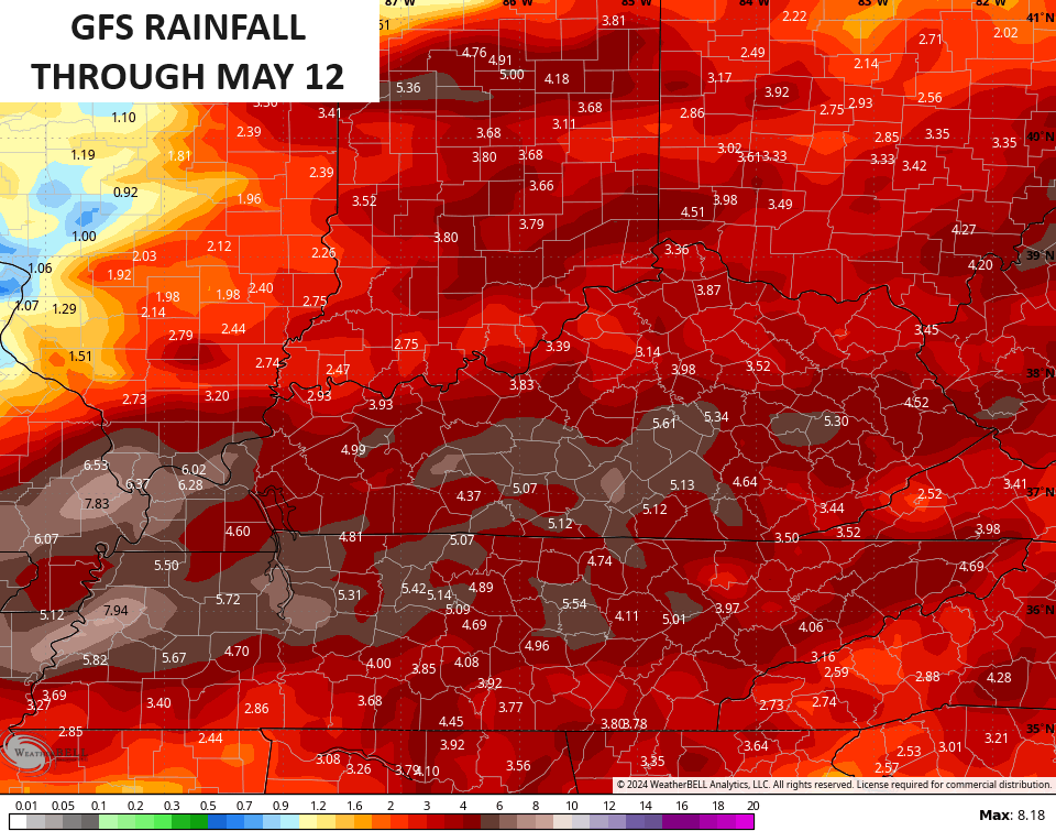
Waves of showers and storms will then kick in on Monday and those should take us through much of next week. It’s not going to rain all the time, but the setup means strong to severe storms will be possible.
This pattern can also put down some pretty hefty rain totals during this time. Recent runs of the GFS and EURO are showing this potential…

There continues to be a growing signal for a much colder pattern for the middle of May. Check out the temp anomalies showing up on the GFS…

Hopefully the warmth can fight this one off!
Enjoy your Derby Day and take care.

It won’t be cold.
As long as it does not fall below 32 I am cool.
😉
No chance it does.
Thanks Chris. Hoping everything goes well with the Derby today, and the rain and possible thunderstorms won’t occur at race time. The cooler than normal period forecast for the middle of May is called by some Folks ” Blackberry Winter. ”
Enjoy the day everyone and be safe !
The Storm Prediction Center’s 4 to 8 day outlook is highlighting portions of western and central Kentucky as potential risk areas for severe storms this coming Wednesday and Thursday. This area will likely be designated as a Slight Risk or higher, as those dates draw closer.
https://www.spc.noaa.gov/products/exper/day4-8/#
Thanks for sharing the SPC site Joe. Something to keep a close watch on. I bookmarked the site for further reference.