Good Tuesday, everyone. Showers and a few thunderstorms are back in the Bluegrass State and they look to stick around for a while. Yes, it’s another stormy setup that looks to be settling in for the long haul.
No, that doesn’t mean its nonstop rain, not at all, but it means we will be tracking on and off showers and storms just about every day for the next week or so.
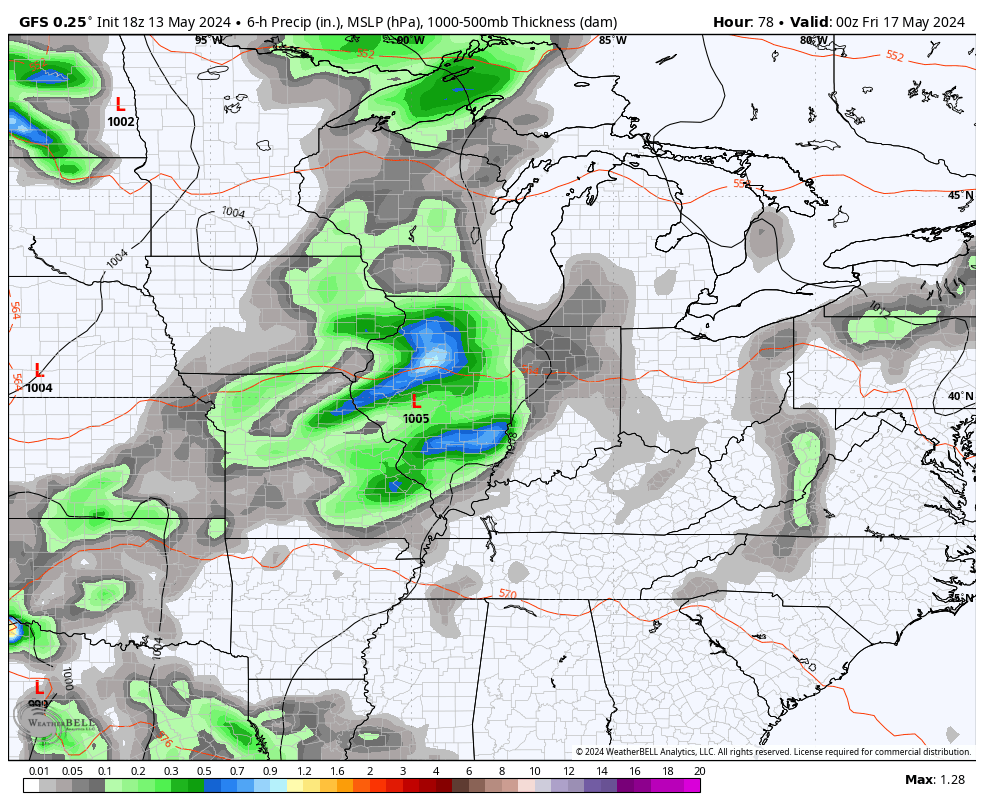
The fun gets started out there today as low pressure spins into the region from the west. Spiraling bands of showers and storms develop and roll through with this action carrying us into Wednesday. Many of us will pick up another 1″+ of rain during this time. There’s the chance for a few spots to pick up enough rain to cause quick rises on creeks and streams.
Can a few strong or severe storms sneak in today? The SPC has a low-end risk…

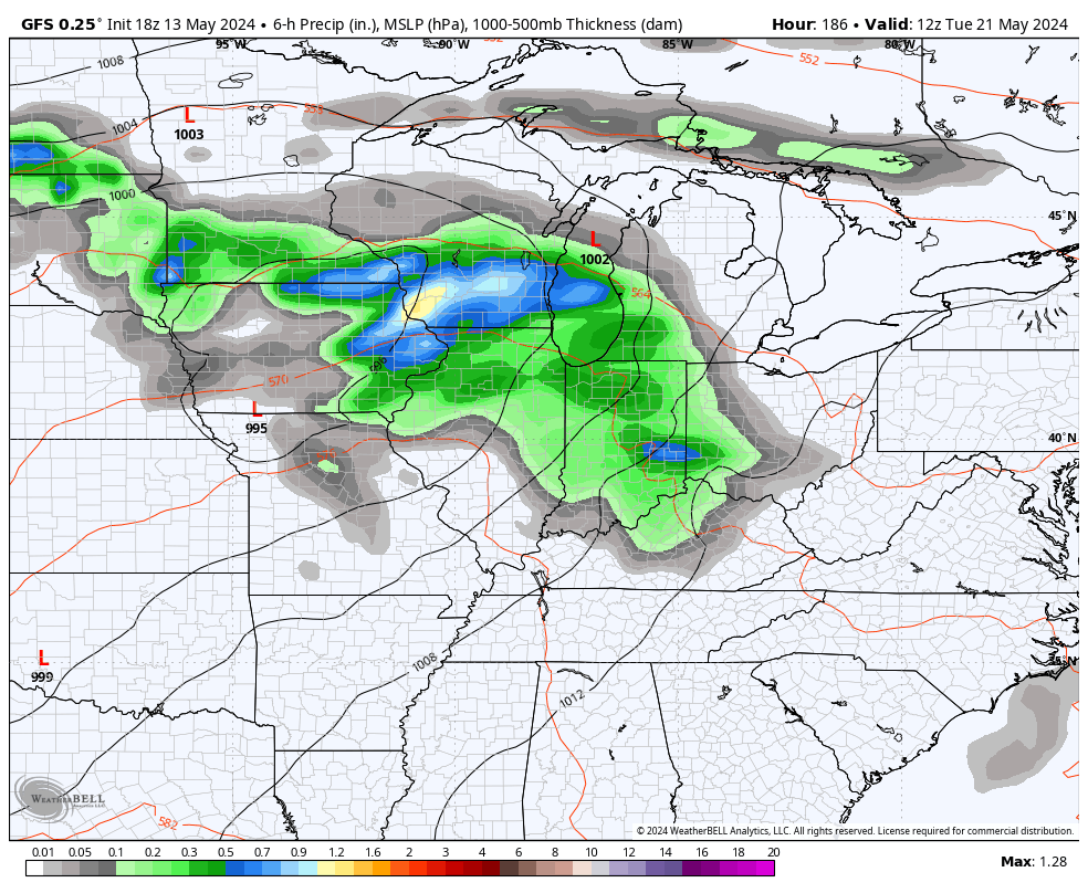
Thursday is a mainly dry and warm day with highs reaching 75-80 in much of the state. Enjoy it because showers and storms settle back in on Friday as another low pressure spins in here from the west. That brings additional showers and storms into the weekend…
A surge of warm and humid air will be noted by late this weekend and early next week as additional systems work through the Ohio Valley. With a farther north track on these lows, it opens us up to a better threat for some strong and severe storms next week…
Rainfall numbers from today through next week are likely to be pretty amped up across Kentucky and surrounding areas. The models are seeing the potential…
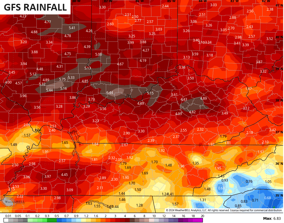
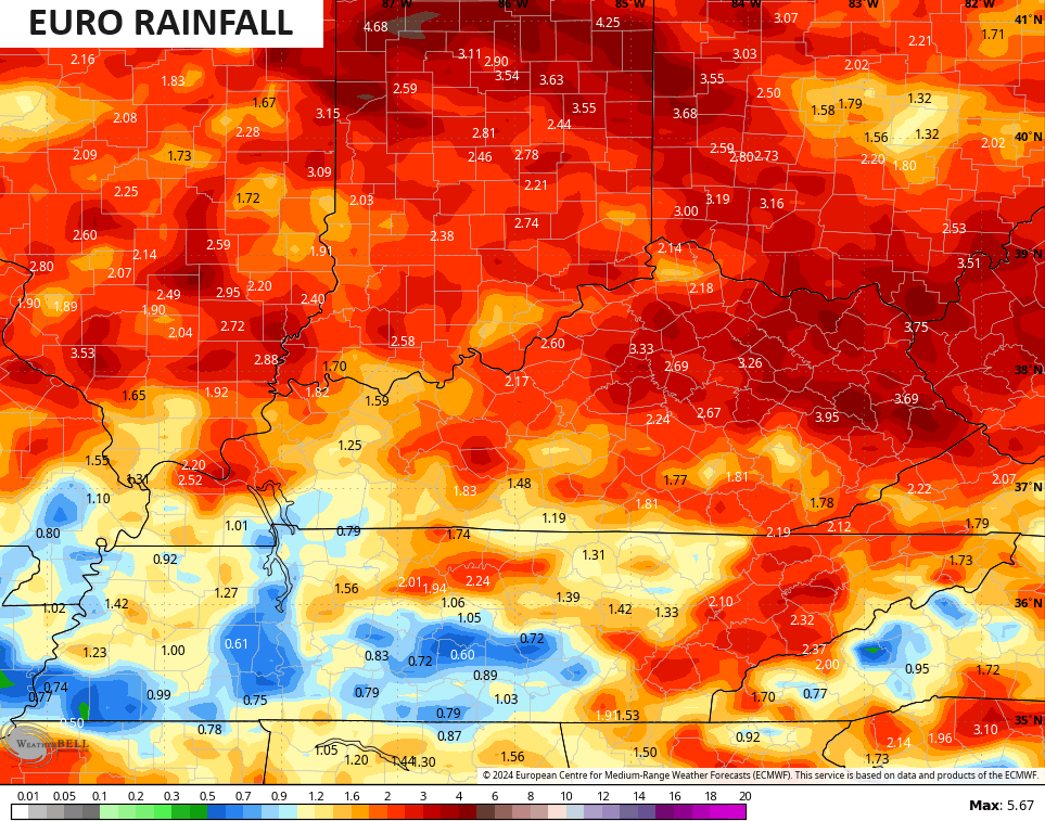
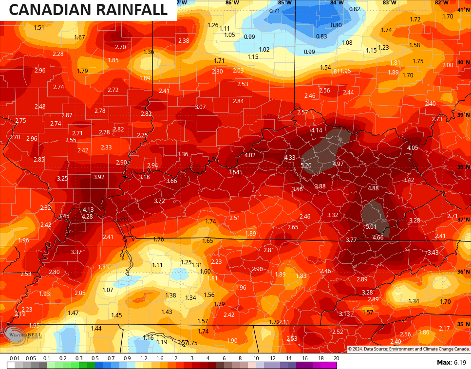
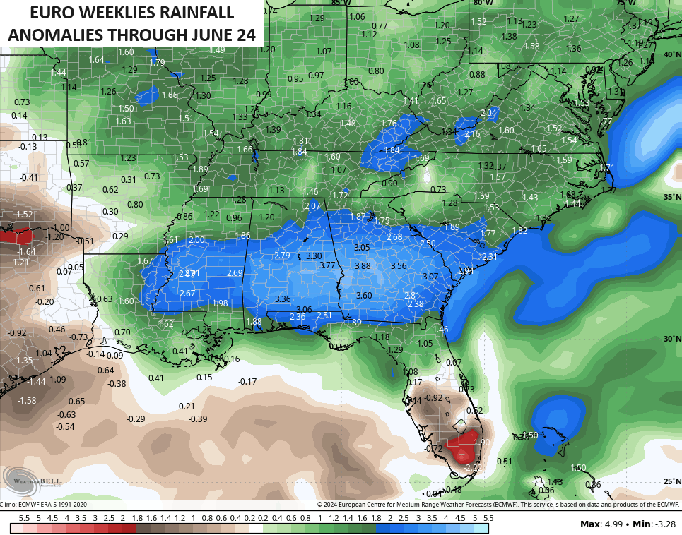
This continues to be part of a much wetter than normal pattern we’ve been in since the start of the year. It’s a pattern that doesn’t look go go away any time soon as the average of the EURO WEEKLIES show above normal rainfall through the second half of June…
Here are your shower and storm trackers to keep you company out there today…

Current watches

Possible Watch Areas

Make it a terrific Tuesday and take care.

Bring an umbrella to the party.
I’ll bet the under on rain potential. 😉
Thoughts?
https://www.cpc.ncep.noaa.gov/products/predictions/long_range/seasonal.php?lead=2
Love it. Predicted to be warm with chances of rain this summer. I think we could take a crack at this prediction gig. Got to figure out how to do the graphics, though.
Subject to change as we get deeper into Summer. When tropical activity begins are rains will end. Unless we have a fetch off the Gulf bringing tropical storms into our area.
Thanks Chris. The current pattern is simular to the Spring and Summer 1979. Lots of flooding that Summer, in fact that was the Summer they decided to move the town of English, Indiana to higher ground.
Have a great day everyone !
Here we go again with wildfire smoke from Canada
https://www.google.com/search?q=wildfires+in+canada+2024&sca_esv=334bdb2960993fde&sca_upv=1&hl=en&sxsrf=ADLYWIIolxa2GB89tN6VlIgmXrDebqEEag%3A1715686701564&source=hp&ei=LU1DZtCzILLBp84Pw5Wh4AQ&iflsig=AL9hbdgAAAAAZkNbPSCOMtHMp_AV6gTRuCdwu4Zio-xb&oq=wildfires&gs_lp=Egdnd3Mtd2l6Igl3aWxkZmlyZXMqAggFMhQQABiABBiRAhixAxiDARjJAxiKBTIIEAAYgAQYkgMyCxAAGIAEGJIDGIoFMgsQABiABBixAxiDATILEAAYgAQYsQMYgwEyDhAAGIAEGLEDGIMBGIoFMgsQABiABBixAxiDATIOEAAYgAQYsQMYgwEYigUyCxAuGIAEGMcBGK8BMgUQABiABEiuc1AAWO40cAB4AJABAJgBgAGgAfgHqgEDMC45uAEByAEA-AEBmAIJoAKxCMICBBAjGCfCAhEQABiABBiRAhixAxiDARiKBcICERAuGIAEGJECGLEDGIMBGIoFwgIREC4YgAQYsQMY0QMYgwEYxwHCAgsQLhiABBiRAhiKBcICERAuGIAEGLEDGMcBGI4FGK8BwgIIEAAYgAQYsQPCAggQLhiABBixA8ICDhAuGIAEGLEDGIMBGIoFwgIXEC4YgAQYkQIYxwEYmAUYigUYjgUYrwHCAhEQLhiABBixAxiDARjUAhiKBcICCxAuGIAEGLEDGIMBwgIOEC4YgAQYsQMY0QMYxwHCAgsQABiABBiRAhiKBcICERAuGIAEGMcBGJgFGJoFGK8BwgIFEC4YgATCAgsQLhiABBixAxjUApgDAJIHAzAuOaAHyns&sclient=gws-wiz
This rain can go away.
and come again another day… Jeff, I just coundn’t resist finishing that old saying you started. LOL…
Tried and true