Good Wednesday, everyone. A slow-moving low is rolling across Kentucky, and this is the first of several on tap for the next week or so. These means rounds of showers and thunderstorms as they move through with the increasing threat for strong and severe storms as we head into the next two weeks.
Temps out there today range from the middle 60s to low 70s in most areas with spiraling bands of showers and a few storms. The greatest concentration is across the eastern half of the state. This is where locally heavy rains will once again be possible.
Thursday is a mainly dry day as we find ourselves between lows. Highs reach 75-80 for most of the state with a slight chance for a shower or storm going up.
As the low spins in Thursday night, it brings showers and storms into the far west and that’s where the Storm Prediction Center is watching for possible strong or severe storms. It’s a low-end risk, but a risk nonetheless…

The low is right on top of Kentucky Friday with rounds of showers and storms spiraling through here. Once again, locally heavy rainfall is a good bet with some areas picking up another inch or two of rain.
The severe threat is pretty low with this Friday system. Here’s what that looks like on the Friday Severe Weather Outlook from the Storm Prediction Center…

Showers and storms linger into the weekend with additional downpours likely. It won’t be a washout by any means with temps 75-80 for Saturday and right around 80 for Sunday.
Warm and unstable air then takes control early next week and this may be settling in for an extended run that takes us into Memorial Day Weekend. Odds favor additional rounds of thunderstorms targeting our region with an increasing potential for severe weather.
One of the medium range tools comes from the CFS and it’s designed to highlight the severe storms signal from a few weeks in advance. The Accumulated Supercell Composite Parameter from May 21 through Memorial Day is targeting the lower Ohio Valley to the west and southwest…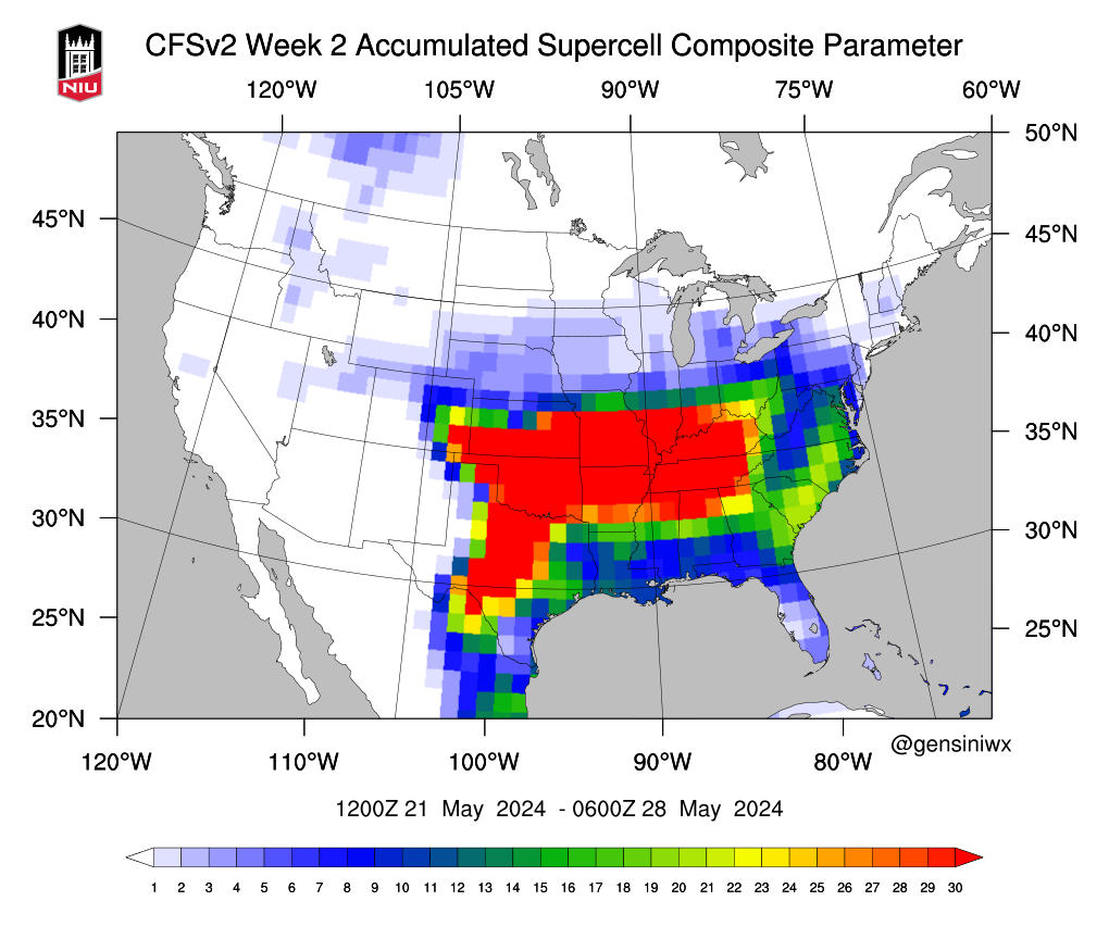
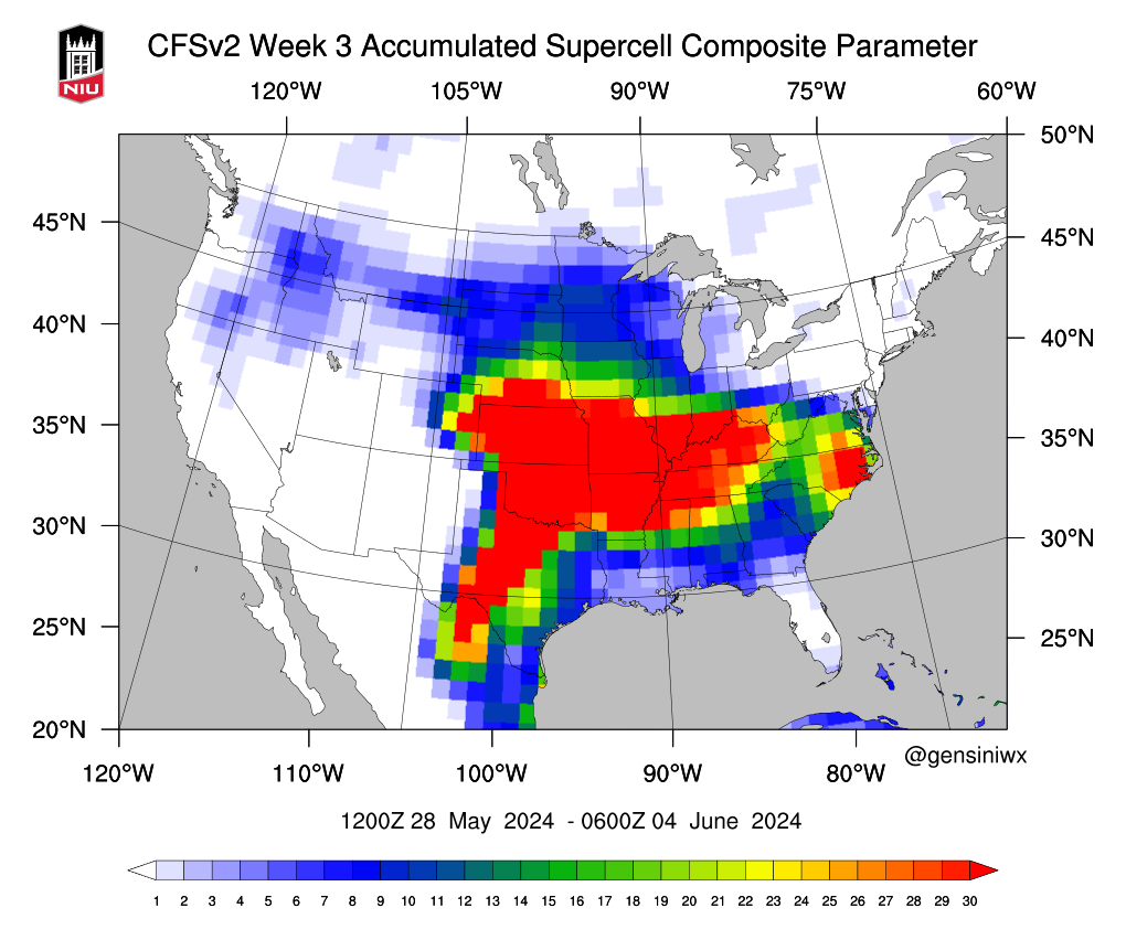
That signal then moves a bit farther north from May 28th through June 3rd…
That’s an interesting semi-new tool that gives us an overall look at a potential severe weather setups down the road.
I leave you with your daily dose of radars to track today’s spiraling bands of showers and thunder…

Have a wonderful Wednesday and take care.

At least the storm threat this week is weak.
I wish the rain threat was weaker.
I wish the severe threat was weaker.
The last few days I’ve noticed the behavior of logging in does this: The first login to comment says you need to check email to verify… why? I have no clue… but that email never comes so just click log in again and it works… Like the 2nd attempt works without even verifying… Oh well…
anyway… we have had over 1.5 inches of rain in my part of Lexington as of 5am.
Mark, check to see if you have your VPN on. If it is on, turn it off, then I believe you log in will be faster.
Yup. Lansdowne. 1.51” in last 24 hours.
I installed a new rain gauge yesterday and it quit raining in my area. Isn’t that the way it goes LOL… I call that ” Murphies Law ” in Nature.
Thanks Chris. Very interesting way of long range weather forecasting. Yesterday, I notice on the ( IR satellite loop ) that the strongest convective energy was well to our south.
Have a great day everyone !
With the transition to La Niña coming into play later this summer, heat domes typically form in the south, allowing for Mesoscale Convective Systems (MCSs) – or strong to severe storm clusters – to ride around the dome.
The Bermuda High I expect to be quite strong with La Nina, and cover a larger area in the Atlantic. This will steer storms arround the High pressure ridge.