Good Saturday, everyone. A significant severe weather event is likely Sunday and Sunday night for much of our region. All modes of severe storms are on the table as a potent storm system rolls through the region.
Before we focus on Sunday, let’s talk a bit about today’s weather.
A lot of the day is dry, but a couple of clusters of storms will be floating around and a couple of those could be strong or locally severe. Temps outside of the storms will reach 80-85 degrees for many areas with a mix of sun and clouds.
Here’s today’s Severe Weather Outlook from the Storm Prediction Center…

Here’s a breakdown of the potential widespread severe weather event Sunday and Sunday night:
- Storms will come at us in waves that develop across Indiana, Illinois and western Kentucky then roll to the east.
- The first wave may develop in early Sunday afternoon with a significant damaging wind potential as it rapidly rolls through.
- Another wave of strong to severe storms pops behind it during the evening and takes a similar track.
- Rounds of storms continue to shoot across the state through Sunday night into very early Monday.
- All modes of severe weather are on the table. Damaging winds, large hail and a few tornadoes will be possible.
- In addition to severe storms, flash flooding will be a concern. That’s especially true for those areas seeing repeat thunderstorms.
The Sunday Severe Weather Outlook from the Storm Prediction Center continues to amplify the threat…

A few tornadoes are possible. Here’s a look at what they’re thinking…

The damaging wind threat is way up there…

Large hail is also a good bet…

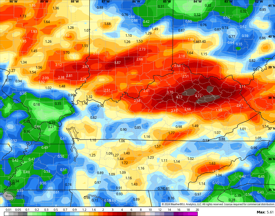
In terms of the flooding threat, my concern is for repeat storms over the same areas. This is something the GFS is showing…
I will throw you another update later today. As always, I leave you with your storm tracking tools for the day…

Current watches

Possible Watch Areas

Make it a great Saturday and take care.

Nice heavy storm currently coming through Richmond.
We had a brief thundershower early this morning. More bark than bite with very little rain, which is good.
Thanks Chris. A very alarming event coming up. I hope we don’t loose power, with the Hurricane force winds the NWS is predicting for late tomorrow. Maybe Monday we can all relax.
Enjoy the Holiday weekend everyone !
There wasl a heavy thunderstorm overnight in BG. According to my PWS, we picked up 2.15 inches of rain in just under a two hour period, which caused some localized flooding in low-lying areas and ponding of water on roadways. But the lightning was incredible; the flashes were almost continuous at times, the type of display that is usually restricted to tornado alley!
We had about 0.12″ since midnight, but we are well above normal for the year so far. In the past 15 years our house has been struck by lightning four times. We lost two television sets and three computer routers plus three telephones. Who said that lightning doesn’t strike twice in the same place ? Joe, I think WE ARE in Tornado alley.