Good Sunday to one and all. A scattering of showers and thunderstorms will continue to be noted over the next few days as June starts to feel the part. Another big change, though, is on the way by the end of the week as we go back toward a deep trough.
Temps today range from the low and mid 70s across central and eastern Kentucky to low 80s in the west. The best chance for those scattered showers and storms is across the eastern half of the state.
Your friendly Kentucky weather radars are on duty…

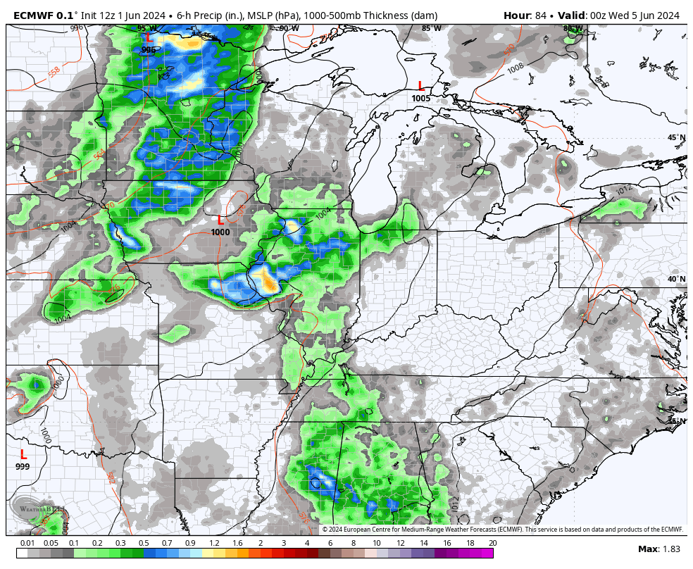
Monday finds just a slight chance for a storm or two with 80-85 in most areas. Those numbers reach the middle 80s by Tuesday as we hang on to the scattered storm risk.
The threat for a few strong storms gets back into the picture by Wednesday and Thursday as a cold front slides into the region. Watch how this touches off the storms…
Much cooler winds come in behind this front by Friday into the weekend as that deep trough takes hold of the eastern half of the country…
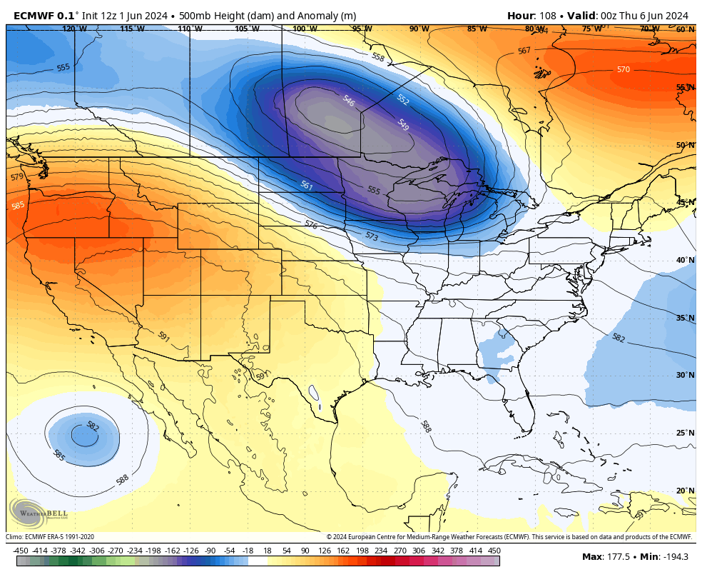
Notice how that trough is flatter on the southern edge and that’s something I hinted at with my last post. That scenario would put our region in the battle zone between the really cool stuff to the north and the warmth to the south. The end result would be waves of strong storms trying to kick in from next weekend into early the following week…
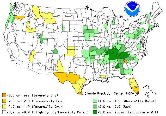
This a continuation of a wet and storm spring across our part of the world. The Soil Moisture Index shows Kentucky being super soggy to begin Meteorological Summer…
Don’t worry, the first time it doesn’t rain 20 inches in a week, the drought obsessed folks will be telling you we are living in the new dust bowl for the hundredth time this decade. Don’t let the facts that our climate in Kentucky is growing much wetter than normal get in the way of a good story. ha
This was also a spring with above normal temps across Kentucky and the eastern half of the country…
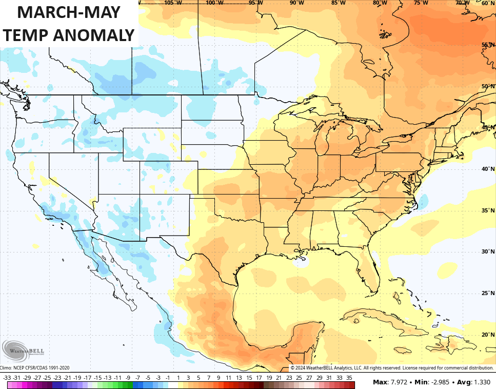
Yes, our climate is growing much warmer than normal during this same time.
Make it a great Sunday and take care.

Maybe we can be above average in both rain and temperatures this summer.
Actually If had not seen the statistics I would of thought it was a normal spring season.
Anyway I am all in on a northwest flow throughout the summer.
Can we have a repeat from last summer only time will tell.
Chris…. I would say that’s 100% true…
In the last 25 years or so I would say easily that more years were wetter than normal than drier. I think that it’s just that this area just can not go that long without rain it seems it can dry up really quickly
A weird issue with logging in I’ve noticed the past few times. The first login attempt wants me to check email for verification….but all I have to do is click login again and totally ignore that and it logs me in the second time without having even verfied anything. I only found out by accident by clicking login again after I got the verification message and it logged me in a few days ago… so the past few times the second login attempt works…oh well
Thanks Chris. The only drought I can remember was from 1987 to 1990, but that was in Indiana. The warmer than normal is just a reaction to the last ice age. More than a thousand years ago.
Enjoy your Sunday everyone !
The Chicago area just recorded its fourth warmest spring ever! The average temperature for March – May at O’Hare Airport was 53.8 degrees, which is 4.1 degrees above normal. There were 11.12 inches of precipitation, which is 0.43 inches above normal, with a mere one inch of snow (which occurred on March 22nd), which is 5.8 inches below normal. https://weather.gov/lot/MaySpring2024
Despite the much-above normal temperatures, there were no daily or top ten monthly records set in the Chicago area from March – May.
From January 20th through the rest of the winter and spring, there were only two days of measurable snow that occurred here, on February 23rd (1.2 inches) and March 22nd (1.0 inches).
Just like everywhere else in the Eastern half of the country, it was another anemic season for snow, with just 22.2 inches at O’Hare (which is 16.2 inches below normal) and 18.7 inches at the NWS Forecast Office in the SW Suburbs.
Thanks Mike for sharing the weather stats. for the Chicago area. Last Winter our total Snowfall for Maple, Kentucky was exactly 5 inches. This coming Fall and Winter I expect another low Snowfall total due to La Nina’s influence, however the Northern States may have an above normal Snowfall season.