Good Monday, folks. The tripleheader of summer weather is upon us this week as the sweat factor really jumps up. 90 degree temps, tropical humidity and the chance for a storm or two are the players of the week.
Temps today range from the upper 80s to middle 90s across the state. Humidity levels will add a few degrees to what your friendly back porch thermometer. With some tropoical moisture pushing in from the south and southwest, scattered storms will go up during the afternoon and evening.
The storms aren’t widespread, but they will be loud and may cause some issues for areas seeing them. Pulse severe storms, like what we had Sunday, will be likely again today and any storm that goes up can put down a lot of rain.
Here are your Kentucky radars for the day…

The rest of the week continues the theme of the past few days as the core of the heat stays just to our north and northeast…
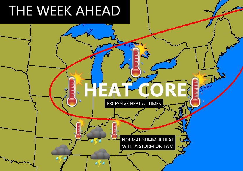
The excessive heat stays north of the Ohio River for the most part.
Temps on any given day featuring mainly sunny skies will be in the 90-95 degree range. Humidity levels add a few degrees to this as our heat index can hit 100 in some areas from time to time.
As all this is happening, the Gulf of Mexico and southeastern seaboard look busy with, at least, 2 systems developing in the next week or so. The National Hurricane Center continues to monitor two systems, one of which should develop soon..

We will see two more systems trying to develop over the next 10-14 days.
How, and if, all this impacts our weather, remains to be seen.
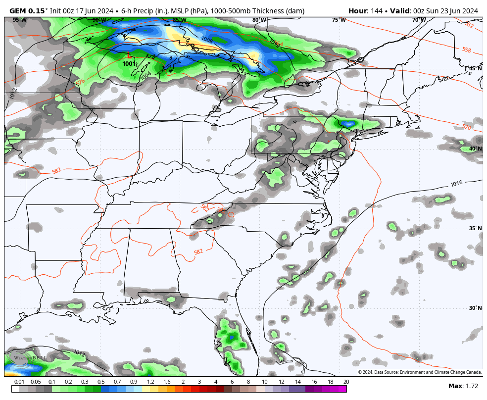
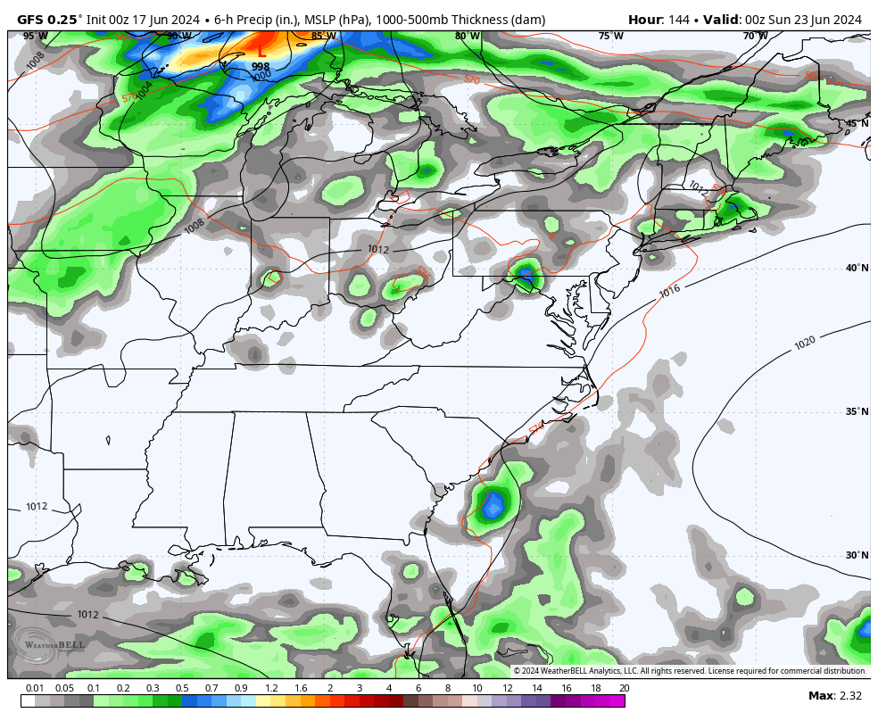
A cold front or two will try to sweep in here for the upcoming weekend and early next week, bringing an increase in showers and storms and a nice decrease in temps…
Canadian
GFS
Have a great Monday and take care.

I hope the two systems on the seaboard have no effects (delaying impact) on the weekend cold front.
Thanks Chris. Hoping this ‘ heat wave ‘ breaks soon, but it’s always been this way as long as I can remember. The system in the Gulf of Mexico could become Alberto by weeks end. The latest run takes the tropical storm or depression into south Texas and then into old Mexico. It could bring some moisture up our way. Hoping it does, as we need rain soon.
By the way, here’s the link to the list of names of tropical storms ( hurricanes ) this season:
https://www.google.com/search?q=list+of+names+of+tropical+storms+2024+season&sca_esv=7898575184a519fd&sca_upv=1&sxsrf=ADLYWIK7Axgy6nZfAMBA7EUuLNTKO2131Q%3A1718619851860&source=hp&ei=yw5wZpW1Ms_Ep84Pm7SwyAo&iflsig=AL9hbdgAAAAAZnAc2zFpT5j9y5FD7k3wgi_ByNPVTWFa&oq=list+of+names+of+tropical+storms+2024&gs_lp=Egdnd3Mtd2l6IiVsaXN0IG9mIG5hbWVzIG9mIHRyb3BpY2FsIHN0b3JtcyAyMDI0KgIIADIFECEYoAEyBRAhGKABMgUQIRigATIFECEYoAEyBRAhGKABSPGiA1AAWNP3AnAAeACQAQCYAXugAZgdqgEFMTcuMjC4AQHIAQD4AQGYAiWgAuUewgIREC4YgAQYsQMY0QMYgwEYxwHCAgsQABiABBixAxiDAcICCBAAGIAEGLEDwgIFEAAYgATCAgUQLhiABMICDhAuGIAEGLEDGNEDGMcBwgIIEC4YgAQYsQPCAg4QLhiABBixAxiDARiKBcICDhAAGIAEGLEDGIMBGIoFwgINEAAYgAQYsQMYRhj7AcICBhAAGBYYHsICCxAAGIAEGIYDGIoFwgIIEAAYgAQYogTCAggQABiiBBiJBZgDAJIHBTExLjI2oAe29gE&sclient=gws-wiz
Have a great day everyone !
Yesterday at 5:00 pm CDT, my PWS near Bowling Green recorded a high temperature of 99.7°F and a heat index of 115.1°F.
The heat is on…
It’s already 85 in Richmond so far. 95 seems like a good bet for a high.
Yesterday, here in Maple we had a high temperature of 92 degrees. I don’t know what the heat index was, but it was not oppressive. I remember growing up in the midwest and the heat was unbearable, but we went fishing anyway.
Forecast highs in Louisville for Friday & Saturday 99.
My area in Taylor county is pretty issolated with an elevation arround 1000 feet, which would make a difference in temperature compared to Bowling Green and Louisville. The night and early morning temperatures are not that bad. Stay cool.
@ 314 PM KLEX temp 93….. both mesonets 89. LOL
@ Jeff… hope you’re happy with this nasty heat and humidity
Ninety one degrees was the afternoon high here in Maple, and the heat index was arround 100 degrees. Not too bad yet.
Glad to see some people receiving rain
Looks like Paducah is the rainfall winner today.