Good Tuesday to one and all. It’s another day with steamy temps and scattered storms across Kentucky as summer continues to flex a bit. This flex may be tempered a bit by some clouds over the next few days.
The clouds out there today may spit out scattered showers and storms once again. Just like on Monday, any storm that goes up can pulse to severe levels and put down a ton of rain in a short amount of time.
Here are your Kentucky radars to track the boomers…

Temps today range from the upper 80s to low 90s for many. Humidity levels will make it feel middle to upper 90s in a few spots.
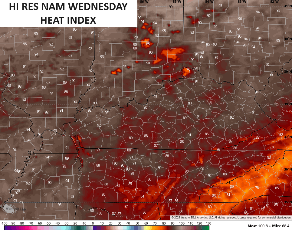
Clouds look to be more of a player into Wednesday and the models are now picking up on this, keeping temps down.
Actual highs may not get out of the 80s in several spots. Heat index values are also way down. The Hi Res NAM keeps heat index values into the 90-95 degree range for a max…
So does the GFS…

Even the EURO is seeing this now…
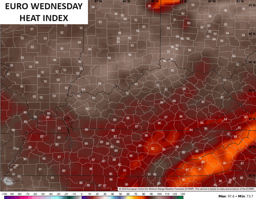
Keep in mind, the EURO had been showing 100 degree high temps in our region every single day this week. That is obviously not going to be close to verifying.
Temps are back into the upper 80s and low 90s Thursday through Saturday with heat index values mainly in the mid and upper 90s at times.
Again, there is nothing about this that is excessive as that stuff stays to our north and northeast.
As expected, the tropics are alive and well with Alberto forming in the southern Gulf of Mexico. This soon to be Tropical Storm looks to head into Mexico…

Another system will likely develop behind that in a similar spot, with another system developing in the western Atlantic and heading toward Florida…

Here’s the satellite shot of all the action down in the Gulf…

Alberto doesn’t look to have any impact on the weather around here, but a weekend cold front does. This front drops in from the northwest late this weekend and early next week, bringing showers and storms to go along with much cooler temps…
Looking ahead, I’m seeing signs of the 4th of July week turning pretty darn hot. The ridge on the Ensembles can really throw some heat our way…
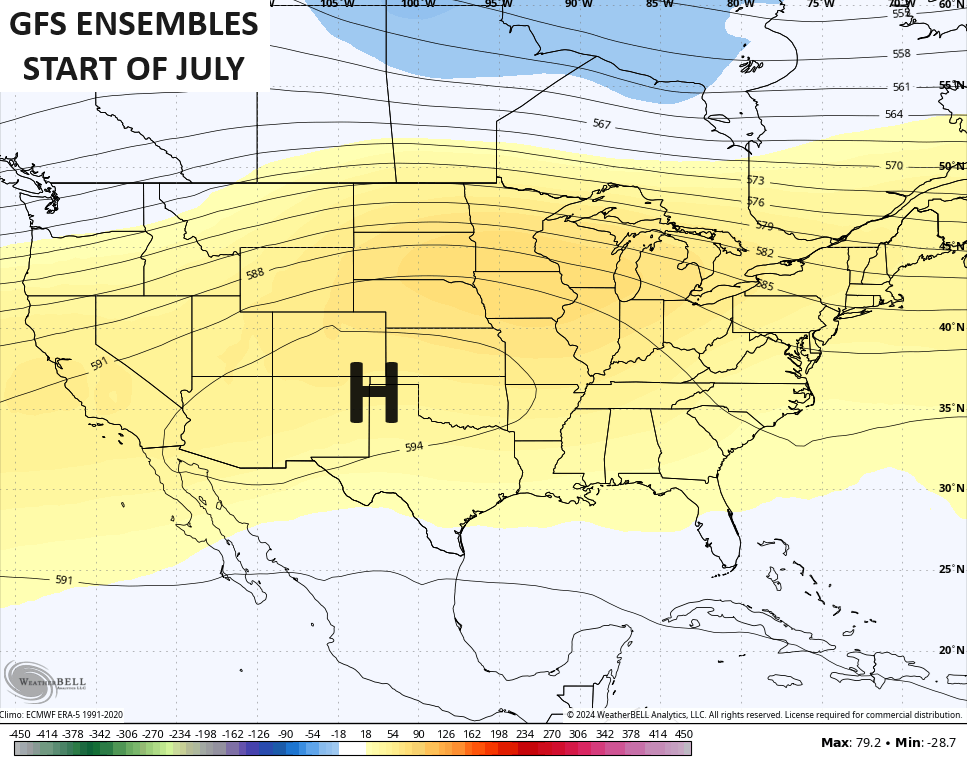
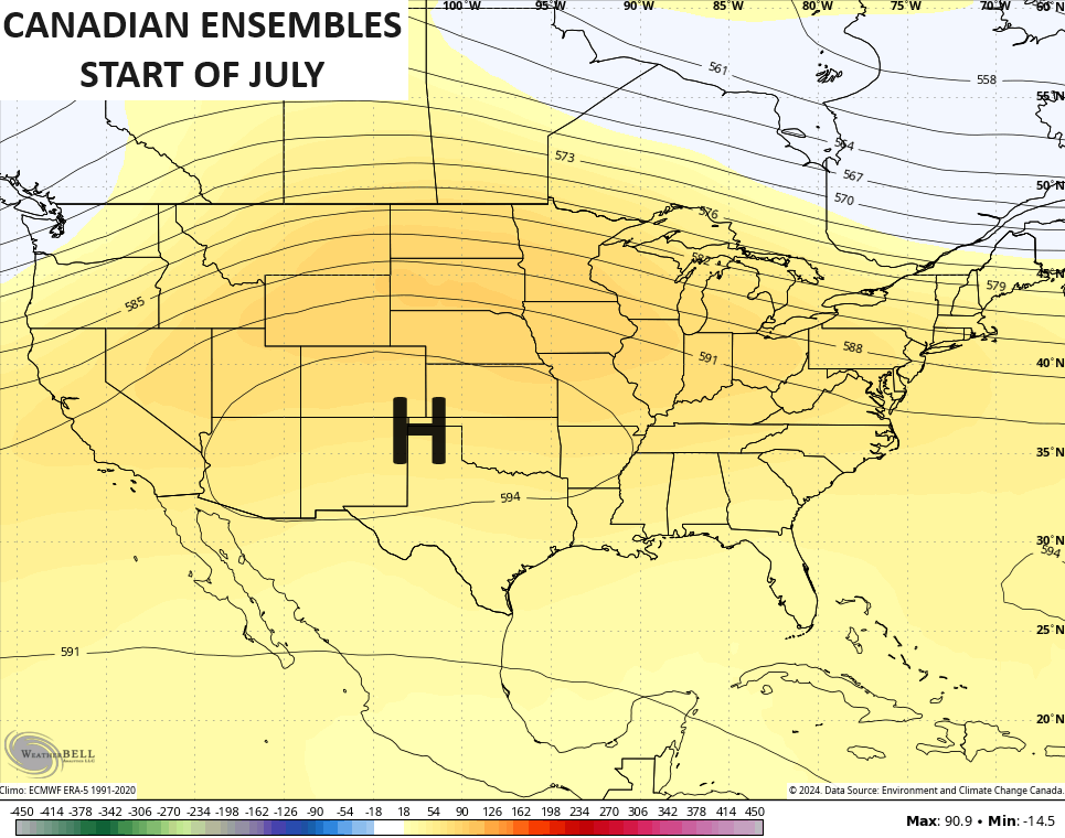
Northwest flow clusters of storms may also ride around a ridge like that.
Make it a great Tuesday and take care.

Thanks Chris. I agree a very typical Summer pattern, but some may suffer from the heat more than others, like the elderly. I’m also concerned about the intensification of the drought in my area, as my area hasn’t receive any rain this month.
Stay COOL everyone, as we want you around to shovel Snow this comming Winter !
The clouds from Alberto are riding the Mississippi River.
Schroeder have you seen that snow out in Montana?? I thought today in this heat I would like to be there.
Crystal, here’s the link to the recent Snows in Montana :
https://www.newsweek.com/winter-storm-warning-idaho-montana-1913522
Thanks Schroeder you always post informative links and pages.
Maybe Alberto ( not exactly formed yet ) is going to give our area some widespread rain in the coming days. I certainly hope so, but I have my doubt’s. All forecast out now do not indicate this happening, but there’s always that chance it will change course.
I doubt it Alberto is moving west.
Probably going to have to wait until the Northwest front makes it down to our parts.
Of course I only giving you my amateur perspective.
The tropical storm ( Alberto maybe ) could combined with the cold front, and then we would receive the widespread rains that we desperately need. Still there is a doubt this will happen. We shall see.
The latest ( I CON ) shows the disturbance 01L moving west into old Mexico. As of now it should not be named Alberto ?
Weather history was made in the Chicago area on Monday, as the high temperature reached 97 degrees at O’Hare Airport, breaking the all-time record high for the date of 96 degrees set way back in 1957. The high was 95 degrees at the NWS Forecast Office in the SW Suburbs.
Nineties are in the forecast here for at least the next five days, with only an isolated storm possible. There’s been very little rain in our area for the last 12-13 days.
As CB has said in his posts, it is much hotter to the N and NE of KY.
As long as I can remember Mike, the midwest suffers the worst of the heat. Where I grew up in Indiana back in the 1950’s and 60’s we use to spend our evenings outside under a huge Maple tree. We had no central air conditioning back then, but no one complained about the heat because we were use to it.
Mike I have been reading on your record breaking heat does it get that hot every year??? I always thought that area as a good breeze and on the mild to cooler side I guess not now.
Looking at Alberto, mid and upper-level steering winds will push Alberto into inland Mexico, towards the Sierra Madres, and the spaghetti models seem to indicate the same path, which means its influence on our weather is very unlikely. However, minimal shear and the steering wind’s influence on that Western Caribbean depression could make a bad flooding situation in Central Florida even worse, but it’s also unlikely to affect Kentucky.
I will agree with that Joe, but I can’t find where they named the storm Alberto ?