Good Monday, everyone. Our week is starting off with Beryl making landfall in Texas with a possible impact on our weather over the next few days. The extent of that impact depends on where you live here in the fine Commonwealth of Kentucky.
Before we get into all that. Let’s get the specifics on Beryl and the latest track forecast from the National Hurricane Center…

And the obligatory satellite shot…

The weather out ahead of this today here in Kentucky looks toasty with upper 80s and low 90s with the chance for a shower or storm going up. Tropical clouds will increase as Beryl works across Texas and makes the turn toward Arkansas.
The storm will continue to weaken into a Tropical Depression with the center of the remnants moving into or close to western Kentucky late Tuesday into early Wednesday. The exact track of the remnant low is still a work in progress, but my current thinking means the worst of the weather is across western Kentucky, perhaps creeping into parts of central and northern sections of the state.
Here’s a look at what I’m expecting as of right now…
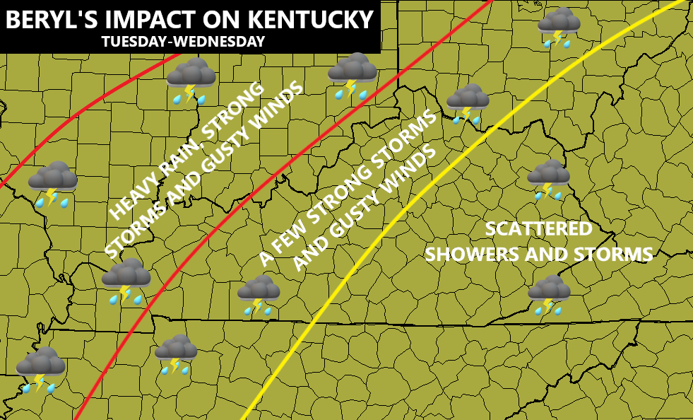
That’s subject to change depending on Beryl’s exact track.
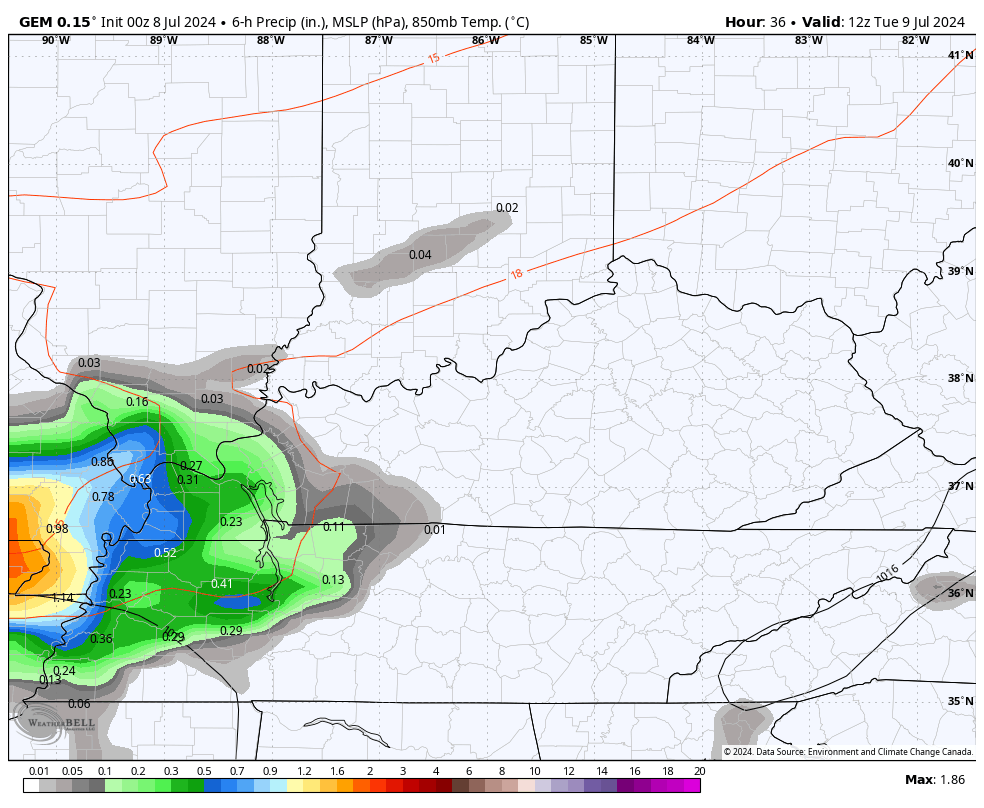
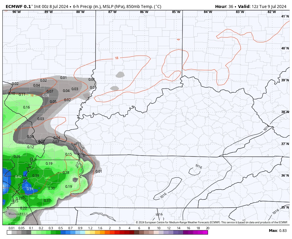
The Canadian and EURO Models match up pretty well with my thought process…
CANADIAN
EURO
The American models like the GFS and NAM look way too far west with this system.
This track I envision may very well bring a few strong to severe storms into much of Kentucky on Tuesday and Tuesday night. Here’s the Tuesday’s Severe Weather Outlook from the Storm Prediction Center…

That low-end severe threat should push to our north and northeast with the low on Wednesday…

A few wraparound showers will be possible behind this exiting storm with normal to slightly below normal numbers to end the week.
I leave you with your Monday storm tracking toys of the day…


Current watches

Possible Watch Areas

Make it a great day and take care.

Looks like my area is the bullseye when remnant of Beryl comes through.
Thanks Chris. I’m praying and hoping that the areas now being impacted by Hurricane Beryl come out with minimal damages, and no lives are taken. I’m hoping that the whole state of Kentucky and all areas that haven’t received much rain since Summer started, make up the deposit. The high pressure that has been amplified ( thanks to a strong negative ( PDO ) will dictate Beryl ‘s exact path. The western and northern edge of the high pressure ( area of lowest pressure, thus rising air will see the most precipitation.
Here NOAA’s probable long range forecast for July, August, and September. Giving a large area a 40 to 50 % chance of above normal temperatures and equal chances on preciptation. These Folks have been very accurate on their long range forecast for several years. Here’s the link : )
https://www.cpc.ncep.noaa.gov/products/predictions/long_range/seasonal.php?lead=1
Have a great day everyone !
Well looks like we have a lot of summer left. I am already dreaming of fall if we even have a fall seems like we go from summer to winter. I hope we have a good fall this year and it lasts awhile.or I should say a normal fall before our new normal took over. I was hoping we would get in on some good rains but at least the west will get it good. Looks like just maybe showers for my neck of the woods.
Crystal, here’s NOAA’s forecast for Autumn 2024. I remember their forecast brought out in August 1976. It read like this. ” A colder, drier Fall and Winter 1976 – 77 ” We really had the Snows those years and they came early, but that’s when I was living in Indiana. Here’s the link for ( S O N ) long range outlook :
https://www.cpc.ncep.noaa.gov/products/predictions/long_range/seasonal.php?lead=3
Thanks Schroeder I am no good at maps but doesn’t that say the dreaded above normal for fall???? Will we ever get back to normal fall and winters??? I remember that year too Schroeder in 77 we had big snows but that was followed by the big flood for our area the 77 flood it was a sad time around Pikeville and Pike county. I remember Dad and everyone cleaning up the flood mud but we were so happy to finally get cleaned up and home.
Crystal, Looking more like this hot and dry Summer will invade our Autumn months. I always look forward to the cooler days and the colorful foliage of Autumn. Not sure what the Winter weather will be like. Being in an La Nina phase, I wouldn’t expect much.
Just remembering Hurricane Ike in 2008 and how the remnants affected us. Most of us in northern Kentucky were without electric for days. We can definitely use the rain but don’t need all the wind.