Good Tuesday, everyone. Rounds of thunderstorms are targeting the region over the next few days and some may be strong or severe. This is ahead a potent cold front that brings much cooler air into the state for the rest of the week.
All of this may very well be leading us into a wetter pattern, too.
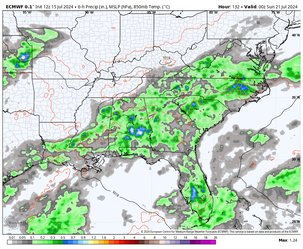
Our day likely starts with a complex of big storms dropping in from the northwest. This should be in weaking mode as it does so but can still produce some healthy wind gusts for some. Once this settles down, watch for a few storms to go up this afternoon and evening and some of those may be strong or severe.
The Storm Prediction Center continues to highlight the region in today’s Severe Weather Outlook…

Rounds of showers and storms will continue to rumble across the state tonight into Wednesday and some of these may also be strong or severe. Here’s the Wednesday Severe Weather Outlook from the Storm Prediction Center…

In addition to strong and severe storms, storms will pack torrential rains that can cause local high-water issues.
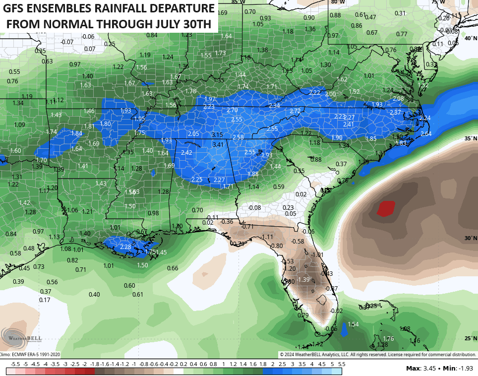
Much cooler than normal air settles in behind this front for Thursday and Friday and we keep the below normal going into the weekend as a few more showers and storms try to flare back up. Showers and storms will then try to keep ramping up into much of next week as a pipeline of moisture streams in from the southwest…
This may very well be kicking off a prolonged period of above normal rainfall for our region and much of the eastern half of the country. The GFS Ensembles show well above normal rainfall over the next two weeks…
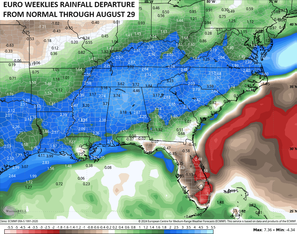
The latest EURO Weeklies keep this above normal rainfall pattern rolling through August…
Bring. It. On.
I leave you with your Tuesday heat and potential severe thunderstorms tracking toys…


Current watches

Possible Watch Areas

Have a terrific Tuesday and take care.

Again…..it’s not going to be “much” cooler than normal.
Well… I for one am thoroughly frustrated with this BORING pattern with these crazy hot temps one day after another….I look so forward to changes… any changes.
@ Jeff… how about this: It’s going to be cooler than it has been? Does that work?
Of course and hopefully we all get rain.
Last night just after 9 PM, a tornadic line of severe thunderstorms slammed through the Chicago area, with numerous confirmed reports of tornadoes, major wind damage, downed power lines, and power outages. Just about every county in the Chicago Metro Area was under a Tornado Warning at some point last night. The NWS is going to survey around two dozen areas across the region today to determine if a tornado or straight-line winds caused damage.
I had just arrived at work last night about 15 minutes before the storms hit, and all our phones went off because of a Tornado Warning that had just been issued. It was pretty bad with high winds and torrential rain, but it moved through quickly, and things quieted down significantly about 45 minutes later.
Just before the storms hit, the dew point was a mind-boggling 84 at the NWS Forecast Office in the SW Suburbs, with an air temperature of 86 and the humidity at 94 percent. So all the ingredients were in place for the atmosphere to explode, which it did with the historic tornado outbreak.
Here is an article from a major Chicago TV station regarding the tornado outbreak, including video of a large nocturnal tornado on the ground right by Chicago’s O’Hare Airport. It’s somewhat hard to see since it’s night, but you can definitely see the rotation in the clouds.
https;//abc7chicago.com/post/illinois-tornado-damage-today-clean-begins-after-storms/15062366/
My bad, let me try to post the link again.
https://abc7chicago.com/post/illinois-tornado-damage-today-clean-begins-after-storms/15062366/
Mike I saw that radar last night and I thought about you it looked kind of scary glad you are okay. Another hot miserable one again today but I am looking forward to the cool down any cool down I will be thankful.
I appreciate your thoughts Crystal!