Good Thursday, everyone. It’s a whole new ballgame out there in terms of our weather as a blast of September air blows into the Bluegrass State. This awesome blast of air carries us into the upcoming weekend as we find a wetter pattern kicking off.
Speaking of wetter, several areas of the state picked up 1″-4″ of rain with this last front. Others… Not so much, but everyone did get some beneficial rainfall.
Some of those showers and storms are lingering into early today across the south and southeast. Locally heavy rains may show up from time to time. Those show up on your Kentucky weather radars…

Slow clearing takes place from northwest to southeast today with that awesome air taking over. Highs reach the upper 70s and low 80s with partly sunny skies and low humidity levels.
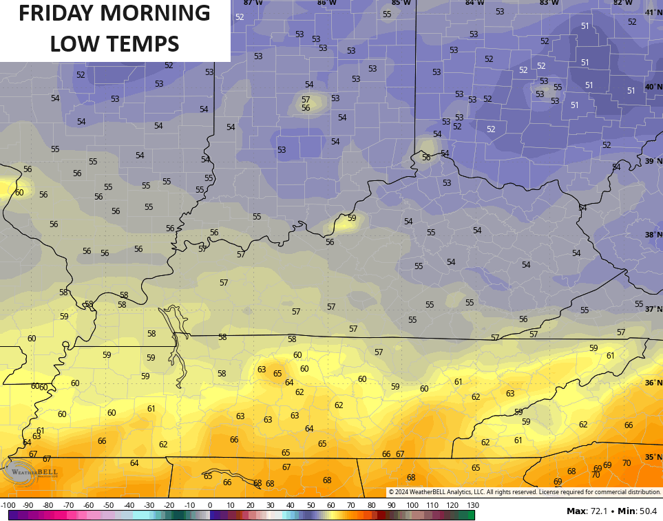
This sets the stage for an abnormally cool night. Lows by Friday morning reach the 50s for many areas…
The rest of Friday is dry with clouds filtering back in with temps back into the upper 70s and low 80s for highs. The clouds are ahead of a few rounds of showers and storms returning for the weekend.
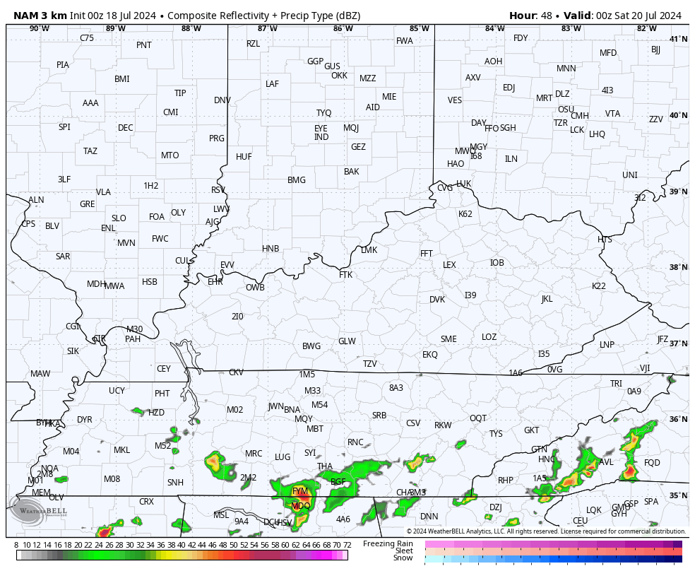
The future radar from the Hi Res NAM shows this first rounds moving in from the southwest by Saturday morning…
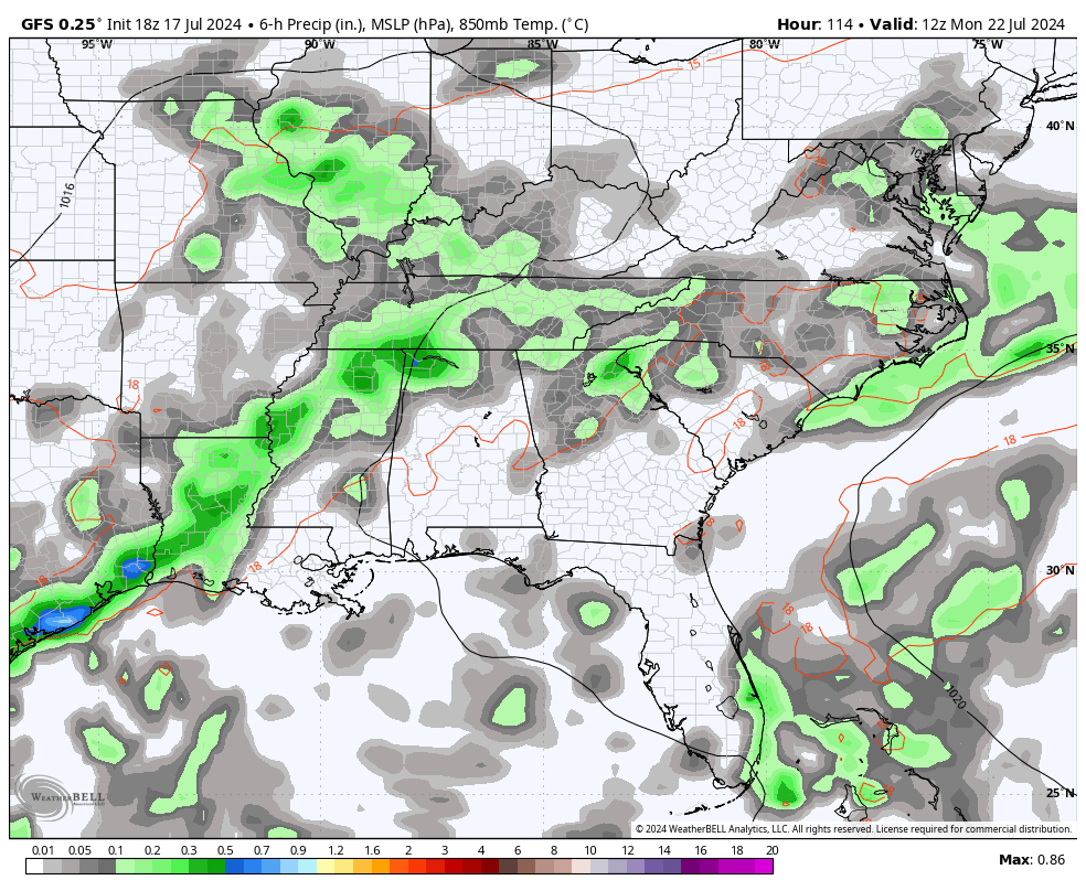
Additional showers and storms roll from southwest to northeast Saturday into Sunday with the greatest concentration across the east and south.
This begins what looks to be a much wetter than pattern as our boundary that’s stalling to our south, returns back to the north and stalls across our region. This allows a few areas of low pressure to roll along it, tapping ample tropical moisture from the Gulf of Mexico.
The end result will be rounds of showers and storms through next week. This animation starts on Monday and ends on Friday…
Don’t be surprised if we aren’t dealing with some flash flood issues at times next week.
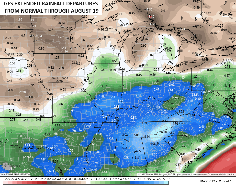
The Euro Weeklies have been showing an above normal rainfall pattern going through August and now we have the GFS Extended doing the same. This doesn’t quite go out as far as the Weeklies, but you get the idea…
Have a great day and take care.

Yes we got rain… over 1/2 inch… Not the best but that’s still a decent amount of rain…
anyway – so glad this heat wave is over…. I can only imagine anyone wanting those temps if they want to enjoy their pool and swim a lot… That’s literally the only reason I can think of to want temps in the 90s and high humidity
Once we made a mistake going to Kings Island …during a heat wave… Like temps mid 90s and high humidity…. we had fun and spent the entire day there riding roller coasters…. but at the same time everyone was miserable because of the heat… You couldn’t drag me to an amusement park during temps like that ever again… If I were going to go… it would be weather like we’re getting ready to have… Nice temps… some clouds…Low humidity… no rain.
I like warm, sunny and sometimes hot weather because my mental health is best during those times. I am glad for this week’s precip thus far, but remain skeptical that wetter than normal is returning.
Lately, precip in Warren County has been a feast or famine proposition, and the past 24 hours have been a mega feast, as we picked up 4.25 inches of badly needed rain!
The crazy-high Dewpoint numbers we’ve experienced over the past few months indicated that the proper trigger would kick off a deluge. I think that August will have higher than normal rainfall, because the Gulf’s record breaking water temps ensure a more than ample supply of moisture. And if the Tropics get rolling, look out!
With the NWS Chicago continuing their storm surveys from the severe weather and derecho that pounded the Chicago area Monday night, there have now been 19 confirmed tornadoes in the NWS Chicago Forecast Area. The strongest tornado was rated EF-2, with ten EF-0 tornadoes and eight EF-1 tornadoes.
Unfortunately, one lady in NW Indiana lost her life when a tree fell through the roof of her house and onto her. It was amazing there were no other deaths or serious injuries. The NWS did a great job of predicting this severe weather event and issuing the timely tornado warnings.
There was widespread damage though. A portion of I-55 was closed in the SW Suburbs for over two days because of a whole mess of power lines and transformers that were blown over onto the interstate, which got entangled in several trucks and cars. A tornado was confirmed in that area.
Highs were actually normal today, with 86 in Richmond.
Yea this is more like it…even though 70s would be better…
Gee… I hope Schroeder is ok… very unusual not to see comments from him
I’ve been wondering about him and hope he’s OK too.