Good Thursday, everyone. We have a cold front dropping into the region today and it’s keeping a few thunderstorms going. This boundary slides just to our south on Friday before it boomerangs right back at us over the weekend. This will lead to a stormy setup to close out July.
The scattered storms out there today aren’t terribly widespread with the greatest concentration across the southern half of the state. Locally heavy downpours will be possible in a few spots and your Kentucky weather radars will pick up on it all…

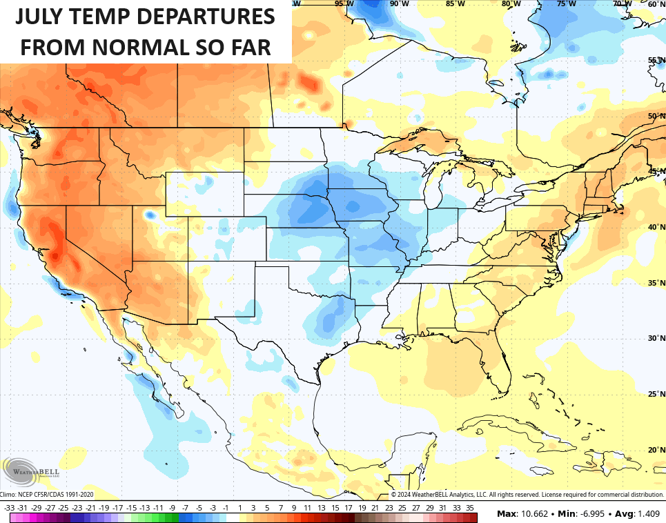
Temps today are back into the 80s as we continue to have a week of below normal late July temps. As a matter of fact, the month of July is now running near normal for much of Kentucky with the west being cooler than normal. Here’s a look at the July temps through Wednesday…
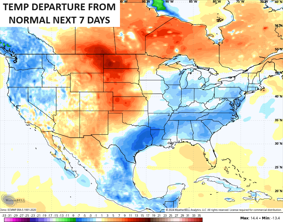
If we look at the overall temp departure forecast for the final week of the month that’s now underway, we find the models suggesting temps averaging below normal…
Contrary to what some weather and media sources have said, this has been a pretty tame temperature summer, even with drier than normal conditions.
Those below normal temps likely come with above normal rainfall for this last week of the month.
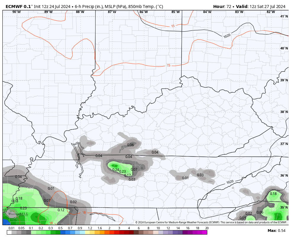
Our front settles into Tennessee on Friday before returning to the north this weekend. That means the chance for scattered storms on Friday is across the far south and west. The threat for storms comes a bit farther north on Saturday with the chance for fairly widespread showers and storms on Sunday.
You can see all this on the EURO…
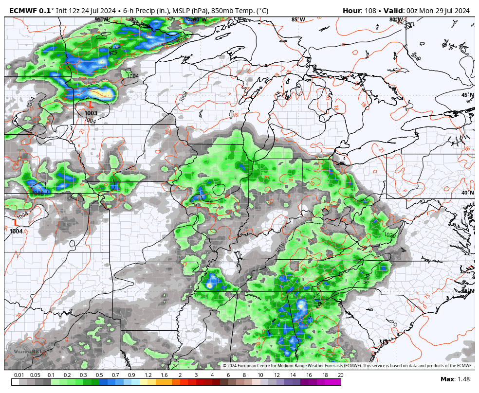
That sets the stage for waves of showers and storms into much of next week. The pattern likely features some big complexes of storms diving in from the north and northwest.
The Euro and GFS are very similar with this…
EURO
GFS
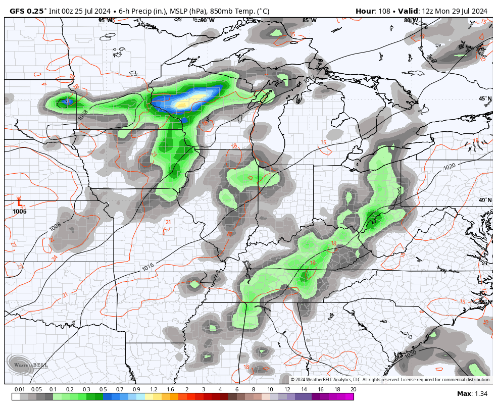
Heavy rains may indeed show up with this pattern to close out July and start August.
Have a happy Thursday and takes care.

Summer hasn’t really been tame at all.
It was a Hot and Humid and very Dry Summer here in Maple. And still there are no real changes in the overall pattern.
NOAA’s outlook for August, 2024 :
https://www.cpc.ncep.noaa.gov/products/predictions/long_range/lead14/
I was hoping for a change. We will have a change, as ENSO / La Nina is being forecast for this comming Fall and Winter 2024 – 25. Typically, this brings a Snowier and colder Winter from the Northwest to Northern New England. The rest of the continental US will be mild with below normal precipitation. Seems like these types of Winters are becoming more common. My last really major Snow was on December 23rd where it Snowed 2 feet making for a very beautiful ‘ White Christmas ‘. That occured in Vanderburgh county, Indiana. My question is does it ever Snow that much here in Central, Kentucky ? I can’t find any records of any major Snowstorms occurring here in Taylor, county saying such.
That 2 feet of Snow fell on December 23rd, 2004. Forgot to list the year.
I’ve only lived here since 1996… so I can’t speak for years before that other than records… there have been several big snows and a LOT of ankle biters (1 -3 inch)…. and some 5- 7 inch …several instances of bitter cold too… a couple of really nasty ice storms… I think the coldest temp I experienced in my life was a few years ago when it was -21
About this coming fall/winter being LA NINA…. Did we not just have an EL NINO winter? I thought EL NINO winters were worse for us….and look at what a horrible winter that was if you like snow/cold… so maybe a LA NINA will be good?
A weak El Nino operating in a positive PDO would give Kentucky the best chance for a Snowy Winter. La Nina operating in a negative PDO would not. Last Winter’s El Nino was rarely operating in a negative PDO ( the sea surface temperatures of the Pacific were not reacting with the atmosphere in Nino 3.4. ) I have already giving up as to having any snowy days for Fall and Winter 2024 – 25, as I found some records on Snows here in south central Kentucky ( Taylor County ) the deepest snow ever recorded here fell in the Winter of 1960 ( 12 inches ) and last Winter we had one 3 inch Snow. Lexington receives a lot more Snow than my area and Western and Southeastern Kentucky also. So why am I even on this Blog !
Thanks Chris, for all your Meteorological information over these many years I’ve been on KWC. Hoping this Fall’s Football season will feature many WINS for the Cincinnati Bengals.
Enjoy this late evening everyone !
The Euro has picked up signs that tropical activity in the Atlantic basin is about to wake up. The lull we’ve experienced is nothing out of the ordinary, we usually see two phases in hurricane development in June /early July, and August onward. Saharan dust is beginning to lessen, and a relatively strong tropical wave has formed off the African coast.
“Contrary to what some weather and media sources have said, this has been a pretty tame temperature summer, even with drier than normal conditions.”
Just wondering if those who work outside every day would say the temperatures have been tame. With multiple days of a heat index >100 degrees, it was energy-sapping conditions. Do you think working inside (with A/C) , looking at computer monitors which tell you what’s happening outside, skews one’s perception of the weather?
Absolutely, we have created micro-environments, which we try to maintain no matter if we’re at home, in our cars, even in some cases, on vacation. But this is a relatively recent development, over the past couple of generations. When I was young, my home didn’t have air conditioning until after I left for college, and cars that were purchased in the 60’s and the 70’s listed air conditioning as an option! In geographical areas like New England and the Northwest, homes without A/C far outnumbered those with.
Not anymore!
Exactly. Grew up in East Tennessee in a house with no A/C. Didn’t live in A/C until after I graduated from college. The first car we ever owned (or drove) with A/C was a slightly-used 1976 Honda Accord coupe we bought in 1977. Thankful for A/C, but I wonder if some weather people live in condos and have no reason to go outside except for a BBQ on the patio and occasional dashes across open parking lots.