Good Monday and welcome to the first full week of Augusts. We have a typical early August feel out there today, but all eyes are on Hurricane Debby rolling into Florida today. This system is a slow mover that should eventually ride up the east coast, though that’s not totally set in stone.
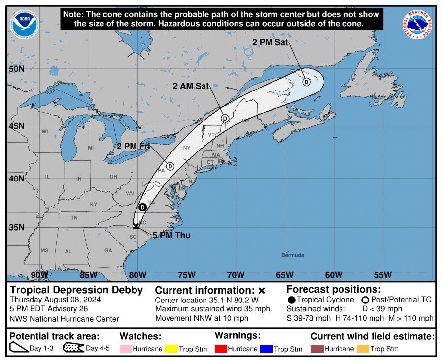
Since the weather here in Kentucky is normal today and tomorrow, let’s focus on Debby. This storm comes ashore in the big bend area of Florida today and then slows down into southern Georgia. It should emerge out into the Atlantic near Savannah or Hilton Head by Wednesday or so.
Here’s the current information and track from the National Hurricane Center…
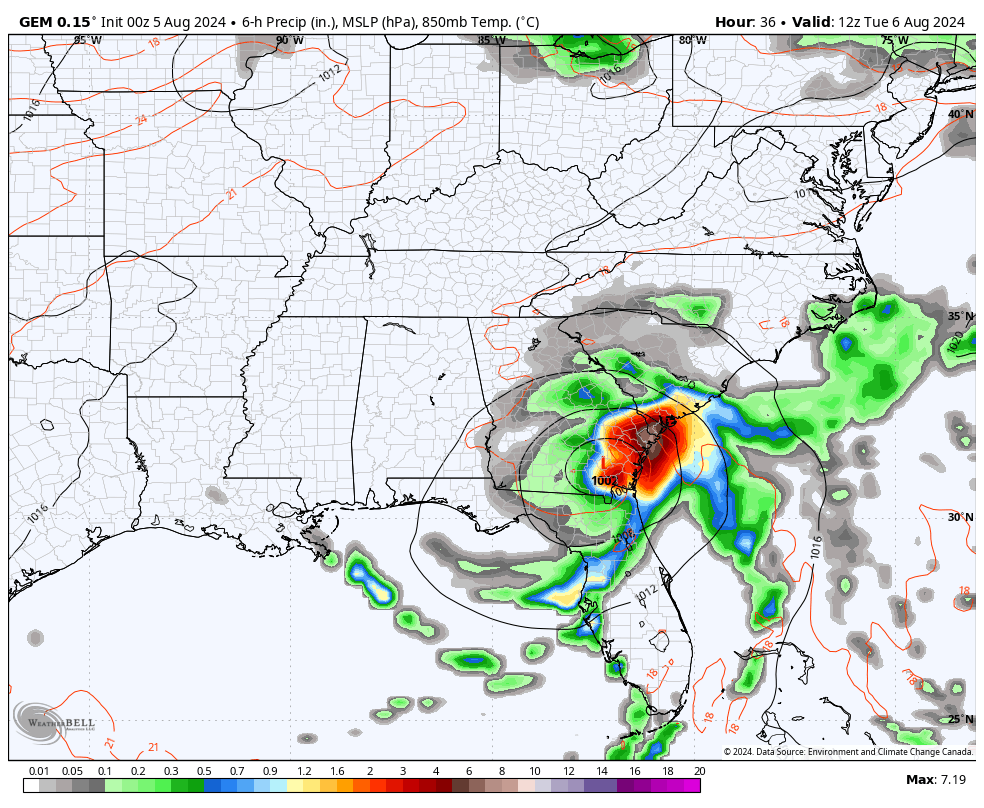
The satellite shows our well-defined storm…

Our interactive radar will take you right into the heart of Debby where you can also pull up live streams from storm chases in the path of this storm…
The majority of the hurricane models eventually take Debby up the coast with a few coming far enough west to potentially throw some rain into southeastern Kentucky…
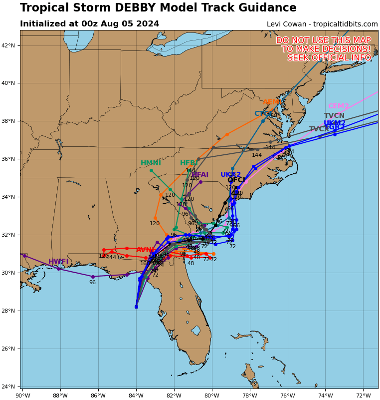
The GFS Ensembles have been showing more members looping around the Gulf, but the majority come up the coast…

The Euro Ensembles are inland and up the coast…

The operational models are having a difficult time with this system with a few, like the GFS, keeping this along the Gulf Coast for several days. Right now, I’m more in line with something similar to the Canadian…
You can see Debby riding up the coast as a cold front drops in here as early as Wednesday or Thursday.
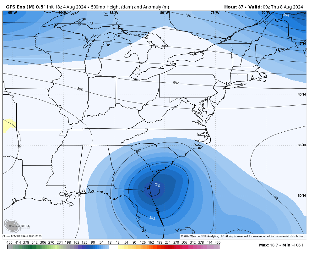
A pretty hefty trough comes in behind this later next week into the weekend and may hang around into early next week. The GFS Ensembles show this well…
Have a great Monday and take care.

Not gonna be “much cooler than normal” for a while.
I notice that cold fronts don’t move very far south, but hopefully maybe the remainder of Debby will help alleviate that, and bring some good soaking rains to the drought stricken areas of east Kentucky and West Virginia.
What’s strange to me about this summer is the fact that it seems like it takes almost no effort to get to 90+. In the past… we would struggle to get to 90 a lot of times only ending up in the upper 80s…. Now.. it can be cloudy and still reach 90 like it’s nothing…. Then again… we’re talking about the airport thermometer here.
Mark, I receive three different temperature readings on my weather sites. I just add up the three readings and divide by three and take the average. I know what you mean about the high temperatures this Summer exceding 90 degrees under hazy, cloudy skies. I remember in the distance past that we would receive cold fronts through the Summer with highs in the 70’s under clear, blue skies. Now the atmosphere is highly polluted with whatever, and it will take a h*e*ll of a cold front to clear it out.
Thanks Chris. My Family living in Florida, went through the worse of what Debby brought yesterday. They had a Storm Surge warning, very heavy rains and sustained winds over 70 mph. Also a Tornado watch was issued. I really need to call my Brother in Law as soon as I get off of here.
Make it a great day everyone !
Just got off the phone with my Sister and brother in Law and they stayed at home and ” road out the storm. ” Over 5 ” of very heavy rain, high winds, which cause the rain to blow sideways. They had no damage, just the flooding in some areas. What a relief.
The weather component that has seen the biggest jump over the past few years has been relative humidity. This ties directly to the warming of our atmosphere, since a warmer atmosphere can hold more moisture. In addition to raising the “misery factor”, extremely high dewpoint levels have increased atmospheric instability, which directly affects severe storm intensity and especially storm frequency. Defined periods of time or seasons when the vast majority of severe weather would occur used to be the norm, but these days we can expect to see severe weather 12 months of the year.
Another reason why it seems like the only constant in our new normal, is change.
Joe, I agree with that. I read an article that when we have the increase moisture in our atmosphere plus the added pollution ( dust or dirt ) in areas where Snow falls will be much more than usual. This happened to a friend ( client ) who lived in Saugatuck, Michigan a few years back. He called me up and said that is home was buried under eight feet of Snow.