Good Tuesday, everyone. It’s another seasonably steamy day across the region as we continue to track Debby. There’s an outside chance for Debby to bring some showers into the east late this week. Following that, here comes a blast of September for the weekend.
Temps today range from the upper 80s to low 90s once again under a partly sunny sky. You will notice some clouds going up this afternoon ahead of a front dropping in from the north and northwest tonight and Wednesday.
This front will be pretty active to our north this evening and there’s the chance for a few storms to get into northern Kentucky tonight and some of those may be strong or severe.
The Storm Prediction Center even has the far north in a low-end severe storms risk this evening…

Here are your Kentucky radars to track the action to the north…

This front touches off a few scattered showers and storms as it moves in Wednesday. The hi res NAM future radar shows the best chance being into central and eastern Kentucky…
Can a little rain from Debby sneak into eastern Kentucky later Thursday or Friday? Maybe.
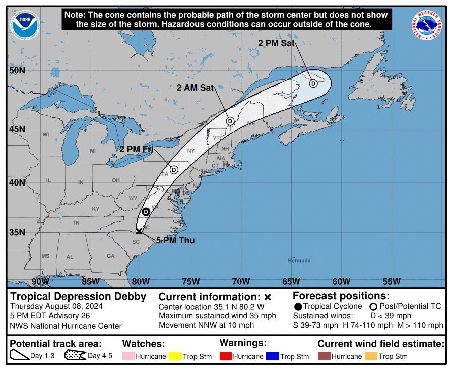
Debby is working offshore into the Atlantic Ocean today and will likely strengthen some as it slowly spins toward the South Carolina coast. Here’s the latest information and track forecast from the National Hurricane Center…

Our satellite shot will show some of the high clouds getting into southeastern Kentucky later today…

Debby should come ashore in South Carolina late Wednesday or Thursday before it slowly lifts northward through the Carolinas and into the Mid-Atlantic states. The GFS brings this just far enough to the west to bring a few Friday showers into central and eastern Kentucky…
Regardless of rain coming that far west, the cool air coming behind this is the real deal. Look how far below normal the GFS takes us from late Friday through Monday…
Lows may reach deep into the 50s this weekend…
The Euro AI Model was one of the first to pick up on the below normal temp blast and continues to show it very well…
Y’all get a taste of fall this weekend.
Enjoy the day and take care.
Other than 50s for lows, this is no “blast” of fall.
Thanks Chris. I’m ready for Fall like weather, it’s been a long hot Summer here in Maple.
Have a great day everyone !
Only high’s in the upper 70’s is forecast over the weekend and the extended forecast for next week 80-85 low humidity. That’s below normal and I’ll take it.