Good Saturday. Much-needed rains fell across many areas of Kentucky on Friday as the remnants of Francine rolled into the region. As this system moves away, we then turn our attention another tropical system that may impact our weather in the week ahead.
Today’s rains are mainly across western Kentucky with some isolated showers and storms going up into central and south central Kentucky. Highs today spike well into the 80s with a mix of sun and clouds.
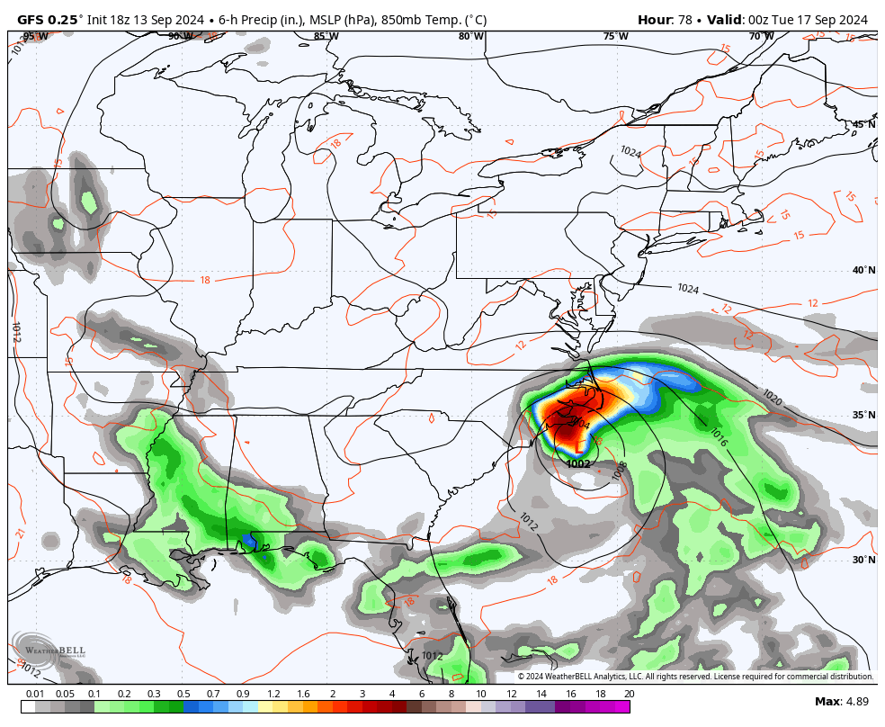
Here are your Kentucky Weather radars to follow along with today’s scattered action…

Sunday finds the chance for a shower or storm lingering across the west with another sunny sky and temps in the 80s across the rest of the Commonwealth.
There’s a system off the southeastern seaboard that’s likely to develop into something tropical over the next few days. Here’s a satellite shot of the area in question…

The National Hurricane Center is watching this area as they also track Gordon way out in the Atlantic…

If the system off the southeast coast does develop, it would be named Joyce.
If this system hits the east coast, can it roll far enough west to bring some rain into Kentucky? Maybe.
Some of the models have been suggesting this for a while now and continue to do so by late Tuesday into Wednesday…
With such a blocky pattern showing up across North America, it’s going to be interesting to see how that plays out.
Enjoy the day and take care.

We got so lucky yesterday as that light/moderate rain sat over us for a few hours… but I think we got 1/2 inch or so.. at least here where I live…I’m totally guessing.
I still don’t understand the bermuda high… how it can prevent storms from approaching us from the west while at the same time allowing the coast of NC to get a huge storm and possibly push that all the way WEST to KY
It’s a puzzle, for sure. And we got .56”, so the ground is soft for the first time in weeks. Yet, no dew even with the dew point at 65 degrees. Steady breeze all night. Perfect time for aeration and overseeding, yet without the system’s moisture that Chris highlighted, it’s going to be sprinkler time again.
Mark, I don’t understand the Bermuda high either. All I know is that when going into a La Nina Fall and Winter the Bermuda High gets stronger. I think it is much better to live closer to the Atlantic and Gulf. Those areas seem to excape severe drought, but not the destruction from hurricanes. Seems there is really no prefect place to live. Just have to take the weather as it comes.
Thanks Chris. I’m hoping that one of those issolated showers develops over south central Kentucky. We keep missing the good soaking rains. Glad for others who have receive a good rain from the remnants of Francine. At least the agriculture is still dominate in most areas of the state that have received timely rains this late Summer.
The extended 7 day outlook for my area of the state calls more late Summer like temperatures with not a trace of rain predicted. If that happens, my area of the state will be place in D2 drought status. Those of you who have received a good soaking rains yesterday, have an enjoyable weekend. I will spend my weekend with other hobbies and forget about the drought.
The 37 day stretch without rain in central Warren County came to an end yesterday, as a cluster of strong thunderstorms pushed its way through the area. My PWS picked up 0.82 inches of rain, which fell in a 20 minute period. Although there was a fair amount of runoff, it was effective in tamping down the fire damage, at least for the short term. The local forecast says there’s an 88% chance for showers and thunderstorms this afternoon, as the wraparound flow from the remnants of Francine pulls Gulf moisture into the area. We’ll take all we can get!
Joe, glad you received a good rain yesterday, that will certainly help alleviate the wildfire danger. I think now that my area of the state is the driest. Must have a curse in my area.
With the coming prediction of transfering from ENSO / neutral to a weak ENSO / La Nina this Fall and Winter. I expect the drought to continue in the Southwest and maybe north to the Ohio River. Seems like when we have this scenario, we have mild temperatures and sometimes wet, and when we have cold temperatures it is always without precipitation. except for what happened in 2009. One of the worse Ice Stroms ever in the state of Kentucky. NOAA always says ” that no two La Nina’s are alike. ” I still hate La Nina Winters, as we don’t receive that much Snow. A boring Winter. I wish one of these years we would receive a weak El Nino Winter, operating in a positive PDO and a negative AMO. That Winter would be Snowy for Kentucky. Done, to other hobbies until the weather gets more interesting.