Good Tuesday, everyone. We continue to track rounds of thunderstorms rumbling across the state and some of these may be severe today. At the same time, a developing tropical system is heading into the Gulf of Mexico and will likely impact our weather later in the week.
Let’s start with today and roll forward.
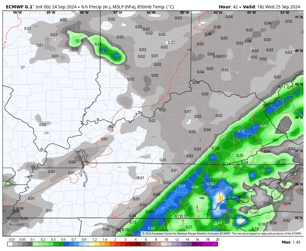
Waves of thunderstorms are rolling through the state as low pressure winds up to our northwest. This puts out region in an area conducive for strong to severe thunderstorms. The Storm Prediction Center is highlighting central and eastern Kentucky for the best chance of severe weather today…

Damaging winds and large hail are the main threats today, with a really low tornado risk.
Here’s the Storm Prediction Center threat outlooks for the day…


In addition to the severe storms risk, torrential rains are likely in some areas and this may lead to localized flash flooding. Keep that in mind today.
Ther threat for showers and storms focuses more on the eastern half of the state later tonight into Wednesday as our cold front stalls. This works back toward the west by evening as low pressure develops along it back across the western Tennessee Valley. Those showers and storms then roll back toward the west during this same time…
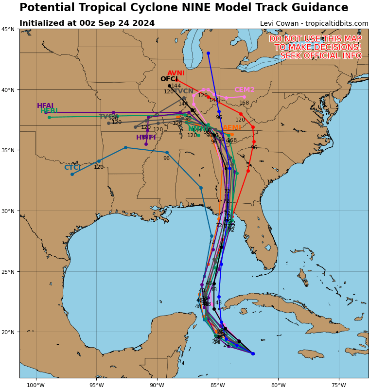
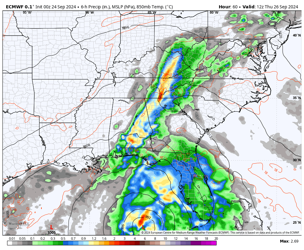
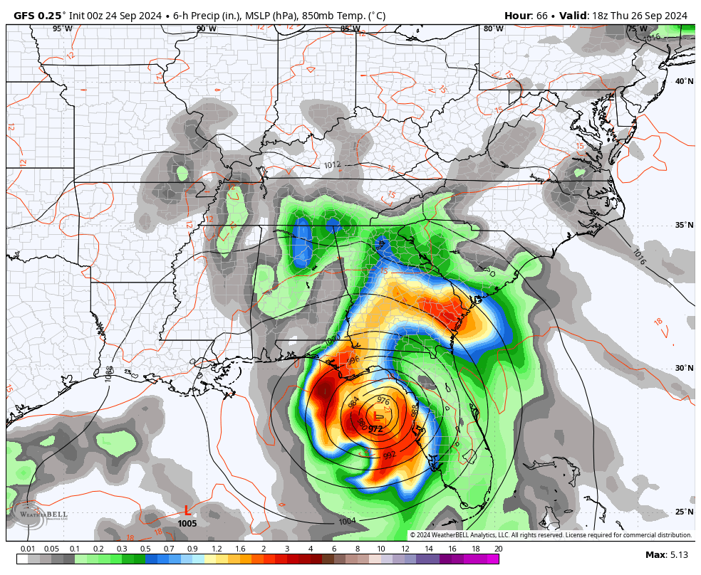
Our developing tropical system down in the Caribbean is heading toward the Gulf of Mexico where it is likely to become a major hurricane that takes aim at the big bend area of Florida. From there, this system curves north and northwest with the remnant low likely entering out region later Friday.
Here’s the current information and track forecast from the National Hurricane Center…

The latest spaghetti plots from the hurricane models continue to be tightly clustered with the landfall and they continue to show what’s left of the storm rolling our way…
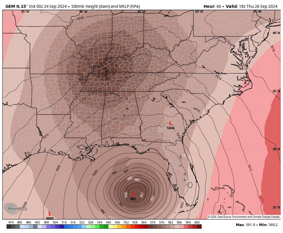
This system will move to the northwest as it pinwheels around an upper level low/surface low spinning across the lower Mississippi Valley. These two systems will then merge into one right on top of us by the weekend…
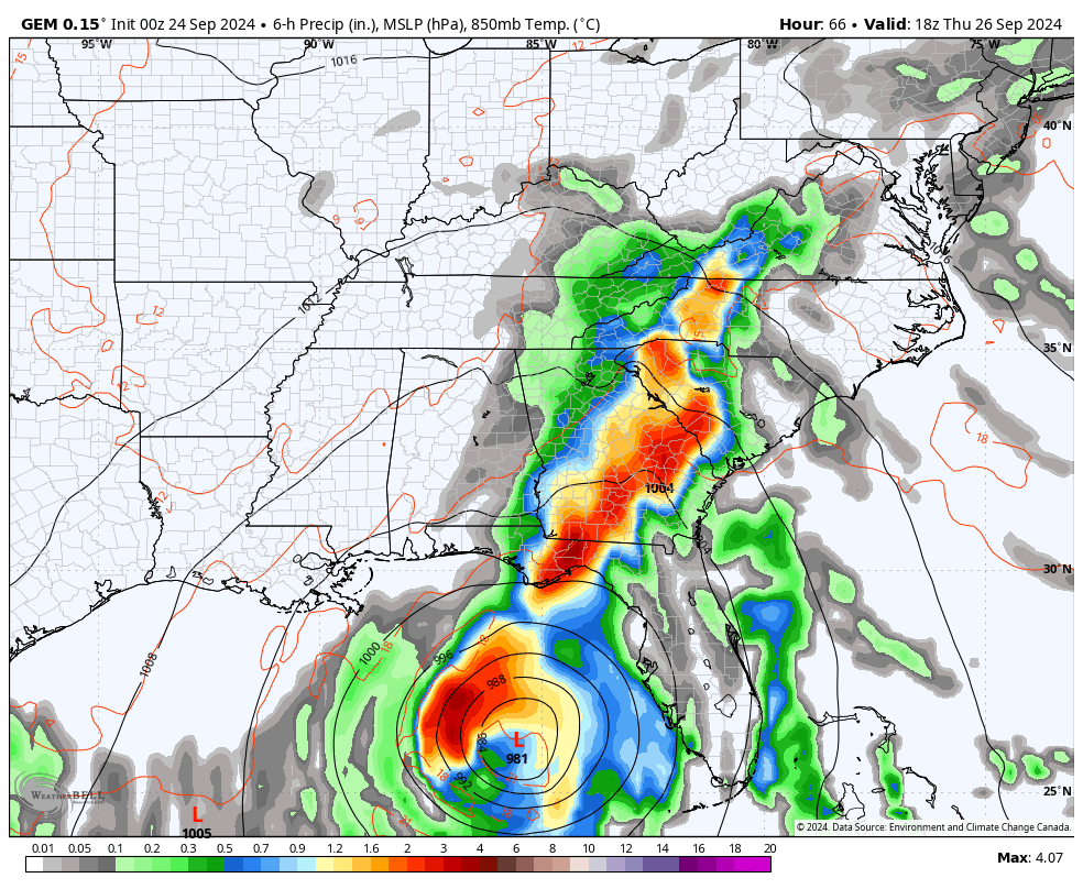
This scenario brings heavy rain in here Thursday night into Friday with rounds of rain, possibly heavy, continuing this weekend into the start of next week. Winds will also be an issue with gusts that can top 40mph at times.
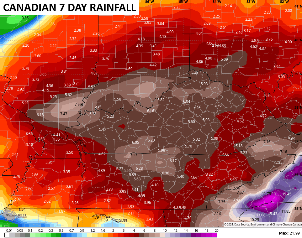
Here’s the look of the Canadian Model with this system…
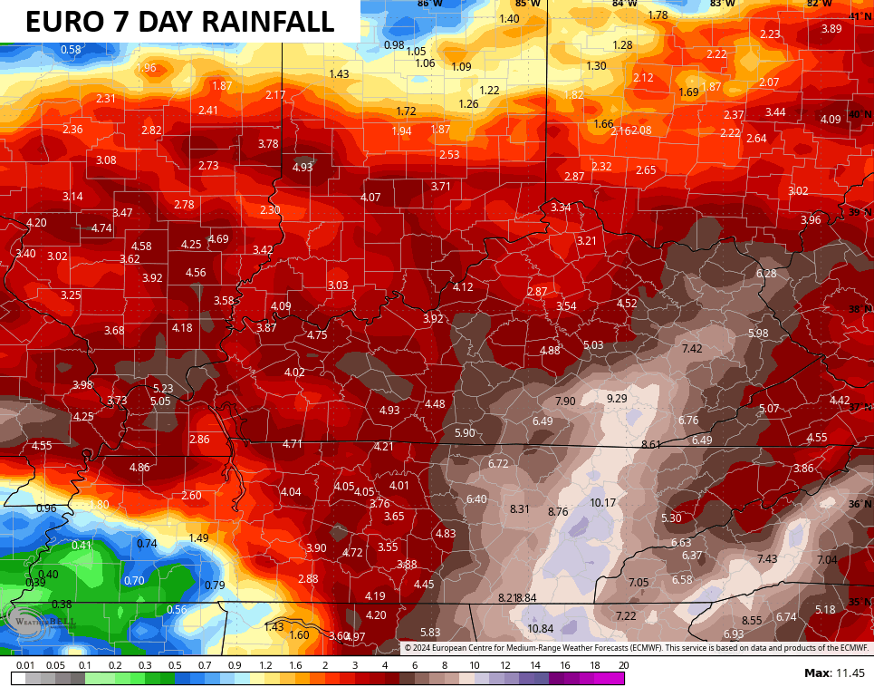
The EURO is similar…
The GFS is coming back to reality…
High water issues will be a concern from time to time, starting today and going through the weekend.
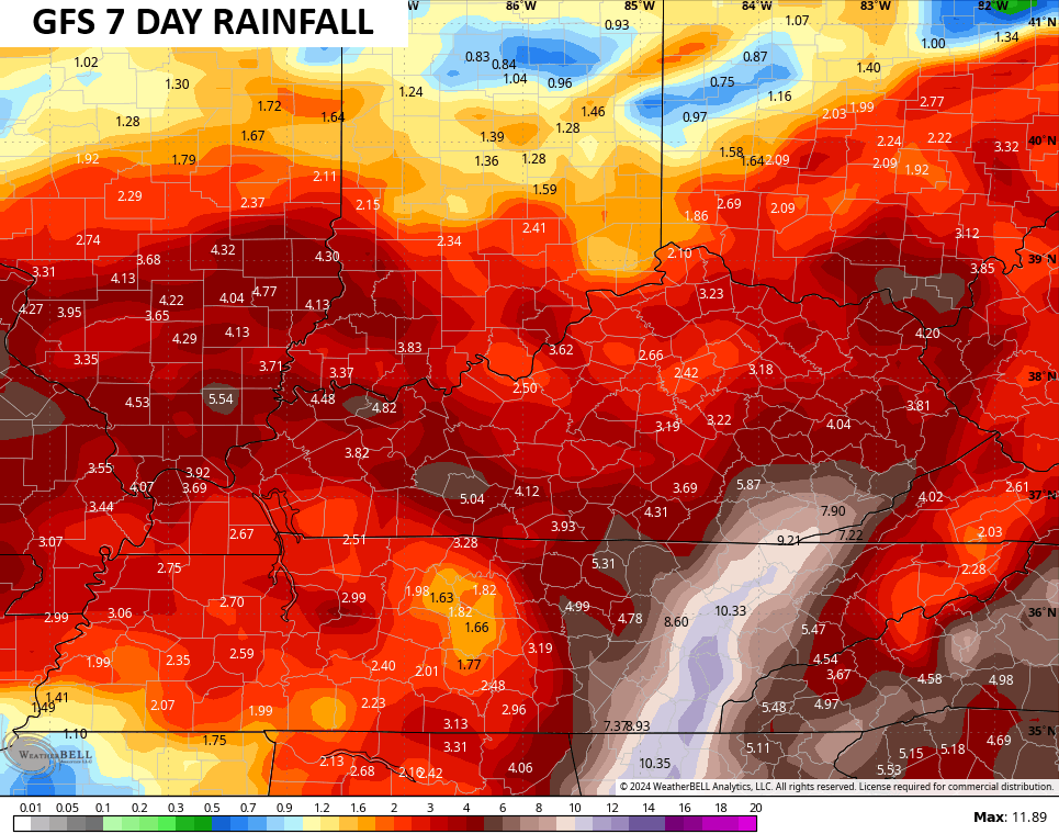
The various forecast models are spitting out some hefty totals starting today through the next week…
I will have the latest on WKYT-TV as needed today and starting with the 4pm news. I may also drop by for another update at some point as well. Until then, here are your storm tracking tools for this Tuesday…


Current watches

Possible Watch Areas

Have a terrific Tuesday and take care.

0.13” yesterday in the form of drizzle. Areas under trees and bushes are still dry. No precipitation since midnight. Looking forward to repeating sessions of rain. It seems as if thirsty plants and animals are looking at the clouds rolling in – and thus far rolling by. Ever hopeful.
Ah, the delightful sounds of thunder in the distance and rain upon the roof.
The 0.80 inches of rain we picked up yesterday in central Warren County helped to quell the fire danger a bit, but it also moistened the top layers of soil, making it more receptive to the heavier rains to come later today, and especially when the tropical system rolls in this weekend. This should help to ease the flash flood potential a bit, but an areal flood watch is still likely later this week.
Thanks Chris. Yesterday evening we had a thunder shower that lasted about an hour, and this morning we had a longer bout with heavy rain that lasted about two hours. Have not been out to check the rain guage, so I would guess over an inch. A good start to ending the drought in my area. Just hope there is more of a widespread rain event this weekend ?
Enjoy the Day everyone !
Concerning when you have almost 10 inches of rain nearby showing up on some of the models above..At least it’s over a 7 day period..Just never know anymore with tropical moisture how much rain one gets..Thanks to a ever changing climate..
Interesting note found on another site..(Today’s NAO value is -2.75 which is a September record..There have been three La Niña winters since 1950 that followed such outcomes (1971-72, 2016-17, and 2022-23). All three favored a predominantly positive NAO during the winter..)Small sample size but with a -PDO and the warm pool of water in the pacific favoring MJO staying in the 4,5,6 warm phases just see another lackluster winter..My thoughts only..
I agree 100 %
I looked back at the last severe Winter’s 1976 -77 and 1977 -78, and the phase of ENSO / El Nino was in place until 1979. The PDO was positive, and the AMO was negative, which made the NAO negative most of the time through those Winters. This coming Winter we are to have ( NOAA says a weak ) ENSO / La Nina. This phase of ENSO ( not always ) brings our area very Mild and sometimes dry or wet, and decreases our chances of any major Snowstorms. UGH !!!