Good Wednesday to one and all. Rounds of heavy rain and thunderstorms continue to target parts of central and eastern Kentucky today as we get ready for Helene to impact us by Friday. This system will bring high winds and heavy rains to much of the Commonwealth.
The setup today into Thursday features a cold front stalled across the eastern half of the state with tropical moisture streaming along and ahead of it. This setup usually spells trouble with repeat showers and thunderstorms that can cause flash flooding.
This boundary will slowly tilt back toward the west later Thursday with the rain shield spreading west and expanding by Thursday night.
Here’s a look at what I’m expecting, including the increased flash flood threat in the southeast…
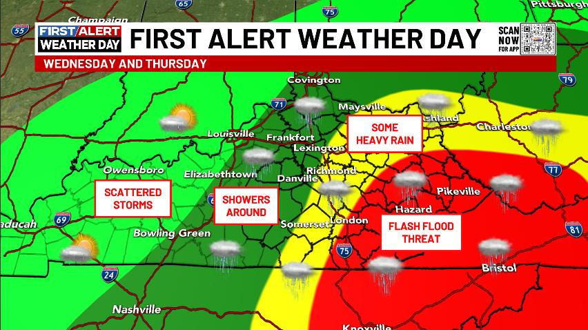
Keep an eye on water levels in the east and southeast, folks.
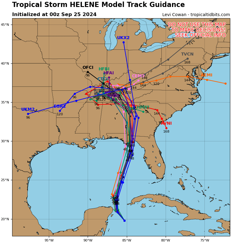
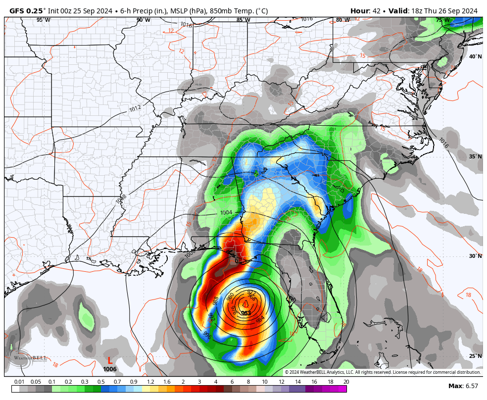
Helene continues to strengthen as it heads into the Gulf of Mexico from the Caribbean. This storm will make landfall as a major hurricane along the big bend area of Florida. From there, this system races north across Georgia and into Tennessee and then Kentucky. There’s a chance this is still classified as a Tropical Depression as it moves into the satte.
Here’s the latest information and track forecast from the National Hurricane Center…

The latest hurricane models track the center toward southern Kentucky and central Tennessee…
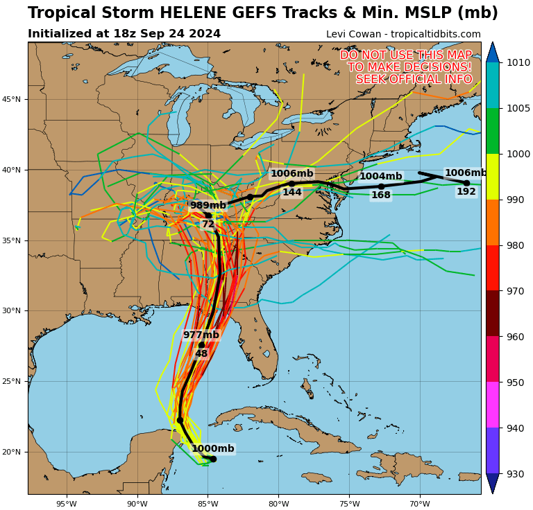
The GFS Ensembles forecast plots are deeper into Kentucky…
I’m still in awe in watching how a big upper level low spins into the lower Mississippi Valley and essentially spins Helene around it and then absorbs it right on top of us. This is the Fujiwhara Effect I’ve talked about for the past several days…
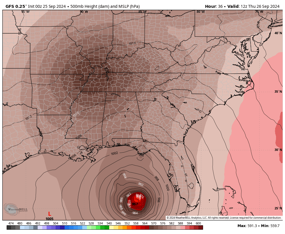
That is a pretty rare thing to have happen right on top of us, but here we are.
This is what that looks like at the surface…
This brings heavy rain and high winds to much of Kentucky Thursday night into Friday…
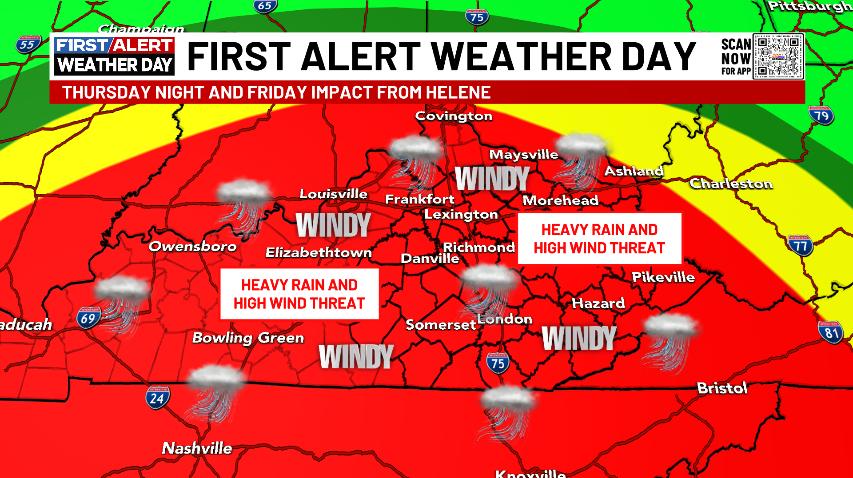
If you’ve ever wanted to feel what it would be like with a Tropical Depression or weak Tropical Storm, Friday might be right up your alley.
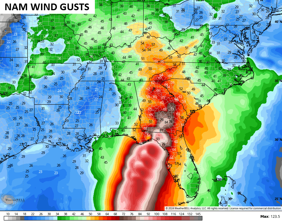
Wind gusts with this storm may very well push 50mph or greater across parts of Kentucky and there’s widespread model support. The GFS is leading the windy charge and is spitting out winds of greater than 60mph…
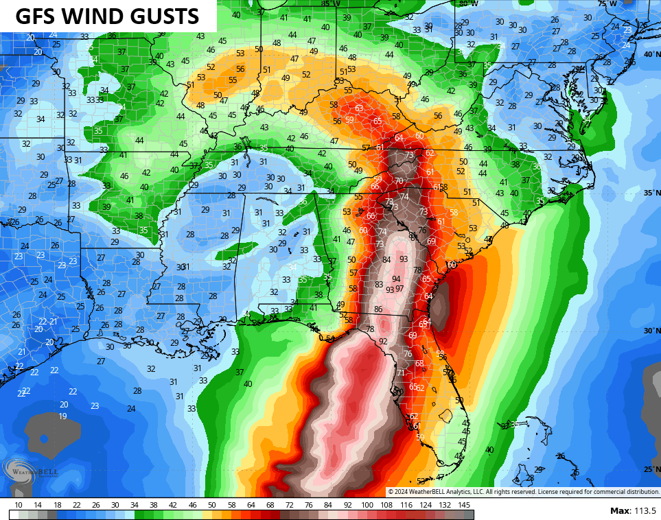
That’s a widespread inland wind event from Florida into the Ohio Valley. Here’s the up close and personal view of the GFS wind gusts in Kentucky…
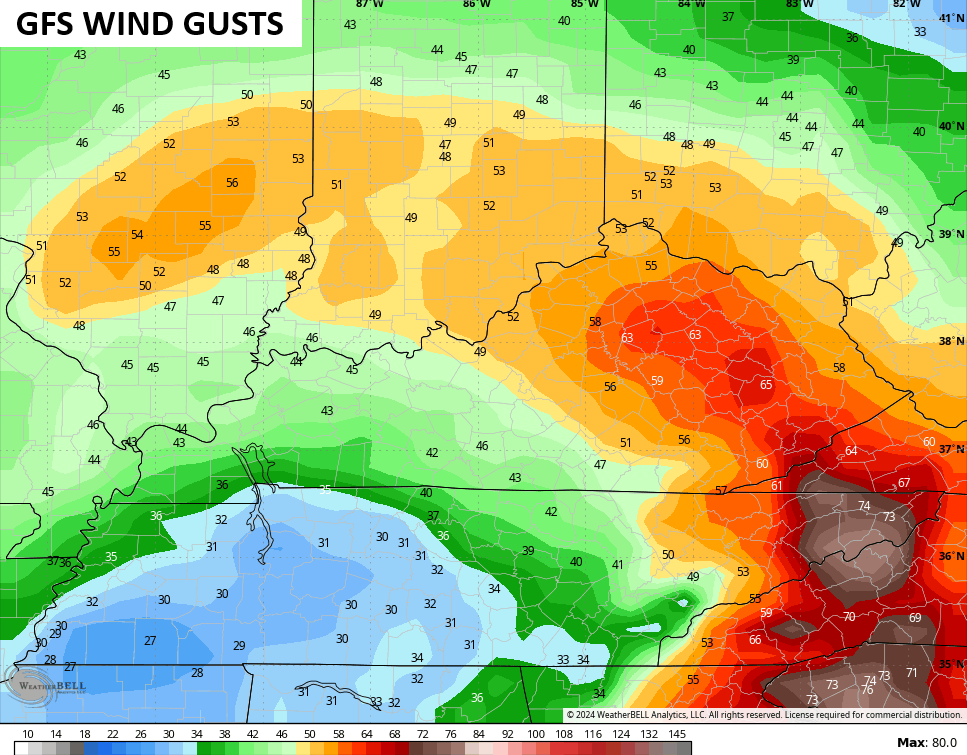
That would cause some significant issues, obviously.
The NAM isn’t as high with the gusts, but it does flirt with 60mph in a few spots…
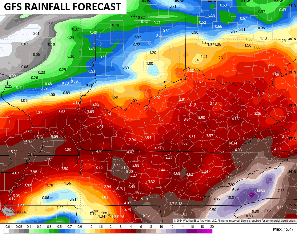
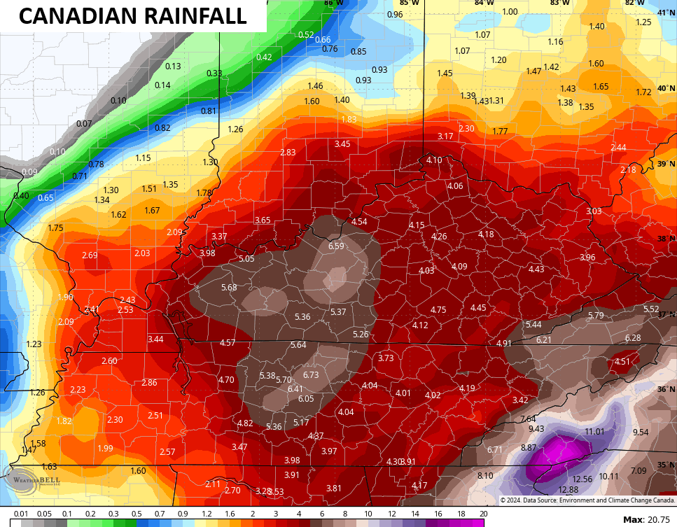
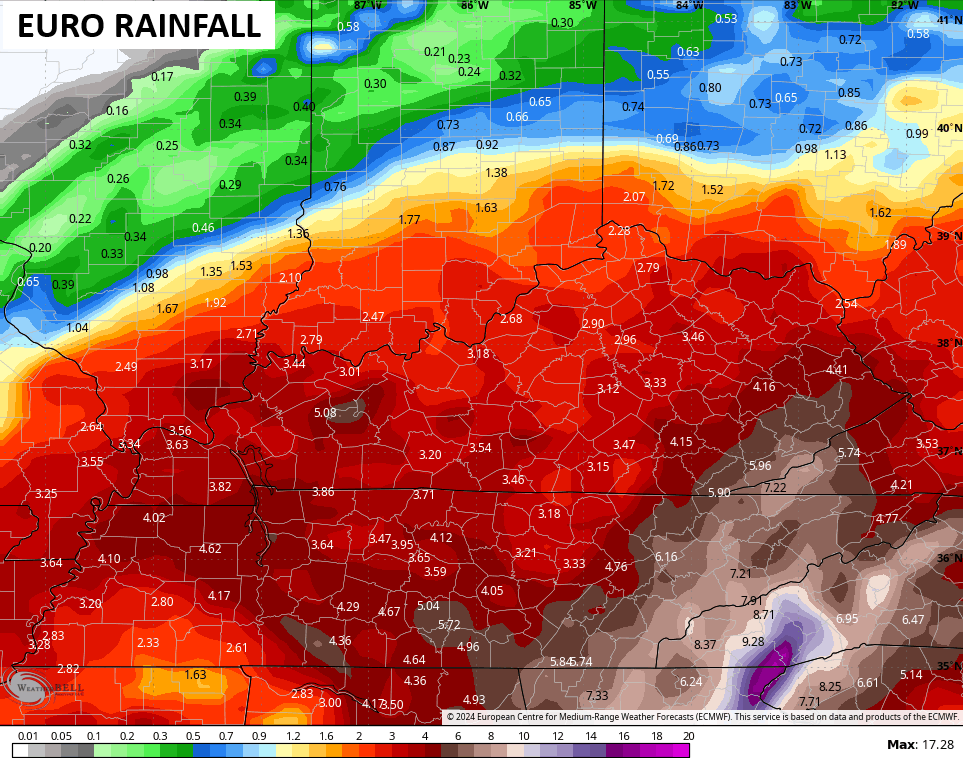
Rainfall totals from now through the weekend are likely to average 2″-4″ for much of Kentucky with the potential for some areas to check in with higher totals. Here are the rainfall numbers from the models during this time…
Flooding issues will be possible in some areas.
Temps for the majority of this period are in the 60s with not much deviation from afternoon highs to overnight lows.
This system finally moves away from us on Monday with a fairly deep trough coming in behind it by the middle of next week. That has the chance to bring a few upper 30s for lows into our region.
I will have the very latest on WKYT News starting at 4pm and I’ll swing by for another update later this evening. Until then, here are your Wednesday tracking tools…


Current watches

Possible Watch Areas

Have a wonderful Wednesday and take care.

Let’s hope for normal soon.
defintiely an interesting forecast for a change…. I seriously don’t know what’s up with this year… Usually as you get older everything goes by so fast… but I feel like this year has CRAWLED by!
Scheduled to fly out of SDF Saturday, seems less than ideal right now.
Water temperatures in the Gulf ahead of Helena’s path are crazy warm, and could stimulate rapid intensification of the storm. We could be looking at “explosive intensification”, except for the fact that the system will encounter moderate wind shear over the northern Gulf. This current setup indicates that the storm could reach the upper end of Category 3 strength, which would make it a major hurricane. Take away the shear, and it would likely reach Cat 5 status!
Thanks Chris. The Fujiwhara effect really fascinates me. Never seen this happen in my many years, but I have seen many times in an ENSO / El Nino Winter, with the PDO in the positive phase, the Northern trough ( negative ) merges with a low pressure ( positive ) over the Southern plains, giving the lower Ohio Valley a big Snow event or a Blizzard.
Tropical Storm Helena’s path really needs to be watch to see if there are any unexpected changes. I’m hoping it moves quickly through the Gulf, so it want be a major Hurricane at landfall anywhere along the Big Bend area of Florida. Hoping this event here in Kentucky will bring many hours of Rain and not the high winds. I don’t want a power failure while my Family is visiting.
Enjoy the day Everyone !
Hey guys, help me out lol. My daughter and I are supposed to go to Gatlinburg tomorrow for just a quick trip, back Sunday. Should we cancel? I’m a little nervous about all the rain and possibly flooding.
I don’t know, but if it was me and a Family member I would CANCEL the trip.
Thank you! I needed validation and not just a paranoid mom.
Helene officially a Hurricane.. 80mph 979….This thing is huge..Goingvto be a large wind field..Looks like NE Georgia/Western NC are gonna get a ton of rain..Bad situation unfolding..Be interesting to see the impact’s in ky if any..
Here’s the latest advisory on Hurricane Helene. Up to 5 to 10 inches of rain, with issolated areas receiving 15 inches in the Southern Appalachian’s. Mud slides are a biggest worry.
https://www.weatherstreet.com/hurricane/2024/Helene.htm