Good evening, everyone. Hurricane Helene is barreling across the eastern Gulf of Mexico and will slam into the Florida Panhandle as a Category 4 storm. This storm will then race to the north with the remnants pushing into Kentucky on Friday. This is going to cause some problems, folks.
Helene is in the process of rapid intensification that will take this to a Major Hurricane by early Thursday.

From there, this storm slams into the area southwest of Tallahassee later Thursday evening. This storm then races northward across Georgia, through Tennessee and into southern Kentucky by Friday afternoon.
This may very well still be classified as a Tropical Depression or Tropical Storm has it moves into Kentucky. Here’s the latest information and track forecast from the National Hurricane Center…

All the operational forecast models, which I prefer at this point, bring the center of circulation of Helene deeper into Kentucky than what the NHC is showing on the track map.
The GFS and EURO both show this fast moving system working across Kentucky between 980 and 985 millibars. That would be roughly equal to barometric pressure around 29.00″ which is insane.
EURO
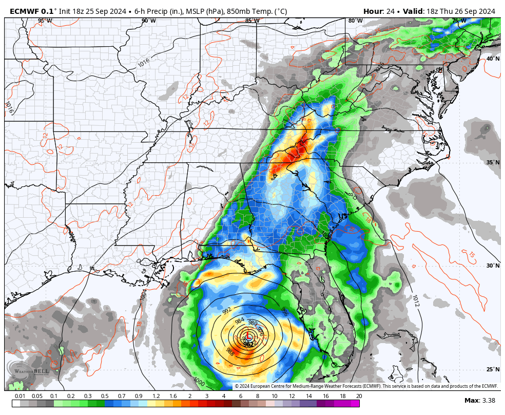
GFS
With such low barometric pressure and such a fast-moving storm system, high winds are an increasing possibility and the models continue to latch onto this potential.
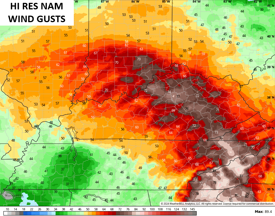
The Hi Res NAM continues to be on the absolute wild side of the spectrum with hurricane force gusts…
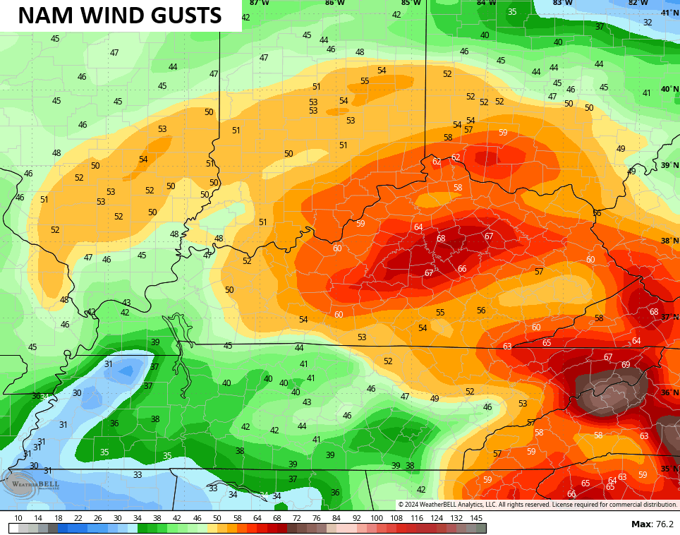
The NAM is lower than that, but still has winds approaching 70mph at times…
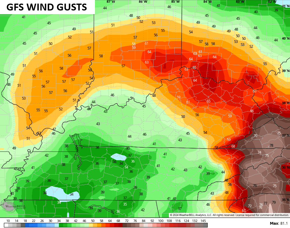
The GFS isn’t too far behind and is a bit farther to the north and east with the worst of the wind…
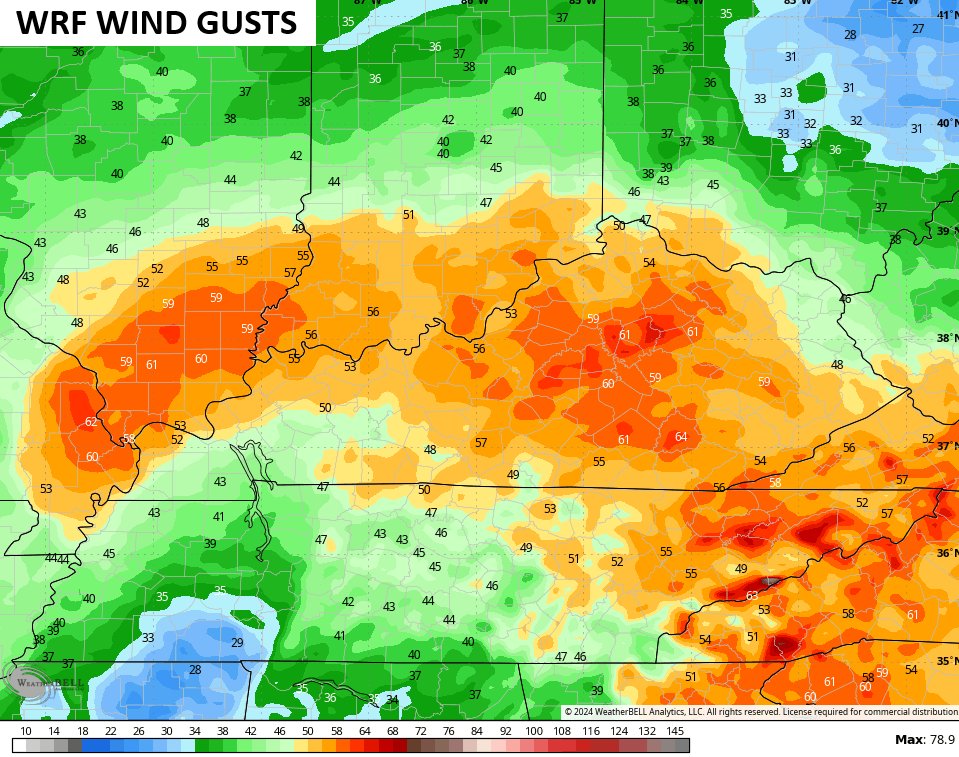
The WRF is seeing 60mph+ gusts…
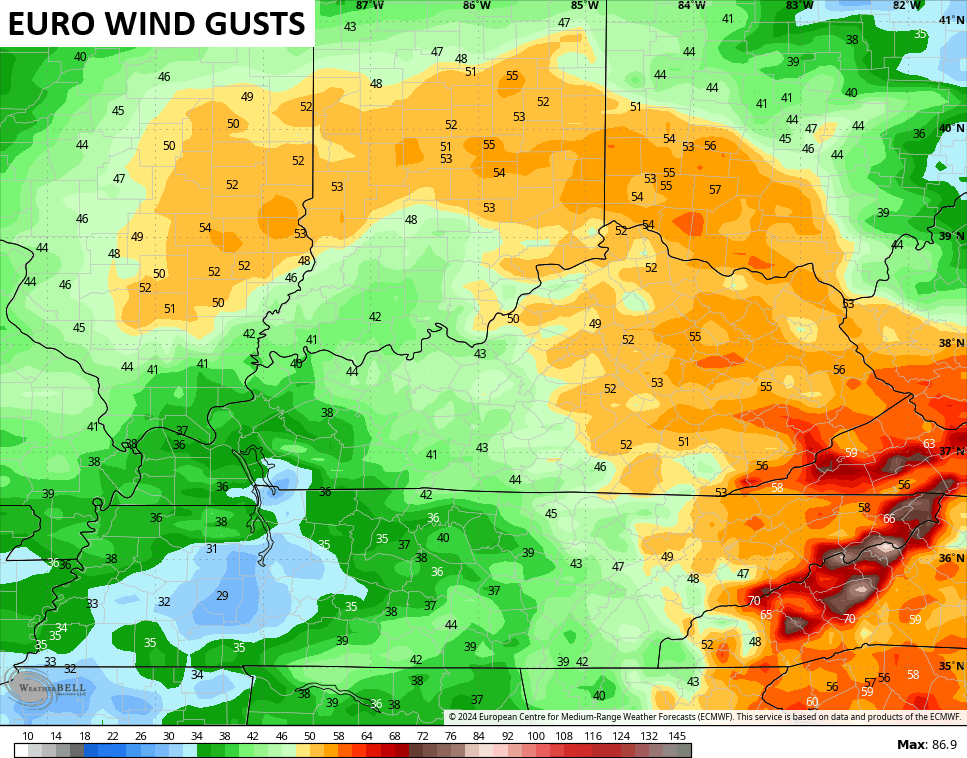
The EURO is on the lower end of the spectrum with gusts in the 50mph to 60mph range…
Regardless on which model verifies, we are likely to see significant winds and, potentially, significant wind damage across parts of the state. This is High Wind Warning type stuff potentially setting up.
The next issue is the threat for flooding. The models continue to spit out some major rainfall numbers through Sunday…
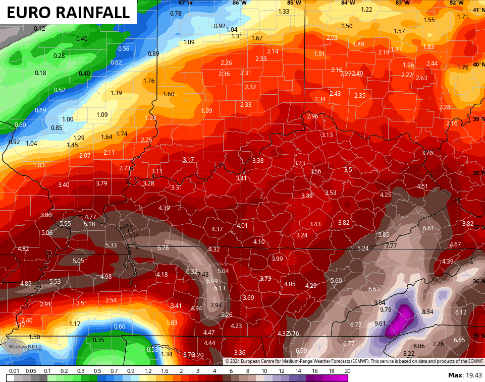
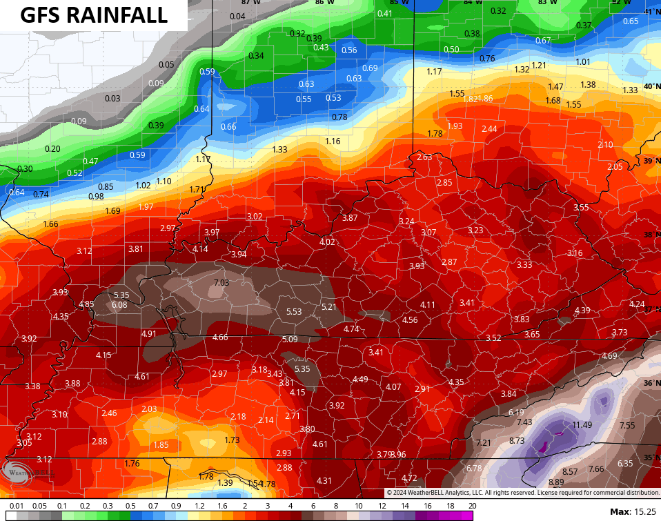
Models can sometimes underdo rainfall forecasts from tropical systems, so keep that in mind.
It’s interesting to watch how NOAA continues to ramp up the flash flood risk outlook for our region…
![[Image of WPC Flash Flooding/Excessive Rainfall Outlook]](https://www.nhc.noaa.gov/storm_graphics/AT09/refresh/AL0924WPCERO+gif/213335WPCERO_sm.gif)
This is a serious weather situation across Kentucky starting Thursday night into Friday with high winds and flooding possible. The flood threat then persists into Saturday and Sunday as our storm sits and spins on top of Kentucky.
I will have the latest on WKYT News on the CW Lexington at 10pm and on WKYT at 11.
Here are your tracking tools for the evening…


Enjoy the evening and take care.

could someone explain to me… why would those forecast models precict the strongest winds in central KY when it’s outside of the cone? I’m not being sarcastic… I really have no clue
Mark this is just a guess. The strongest winds are on the far east side of the center of the storm’s circulation. The highest rainfall totals will be on the north side as it begins to enter the state. Looks like the center will travel right over Maple. The storm may be enhance if it combinds with the upper level low to our west. The Fujiwhara Effect that Chris has been talking this week.